Snow Peak Topo Map Oregon
To zoom in, hover over the map of Snow Peak
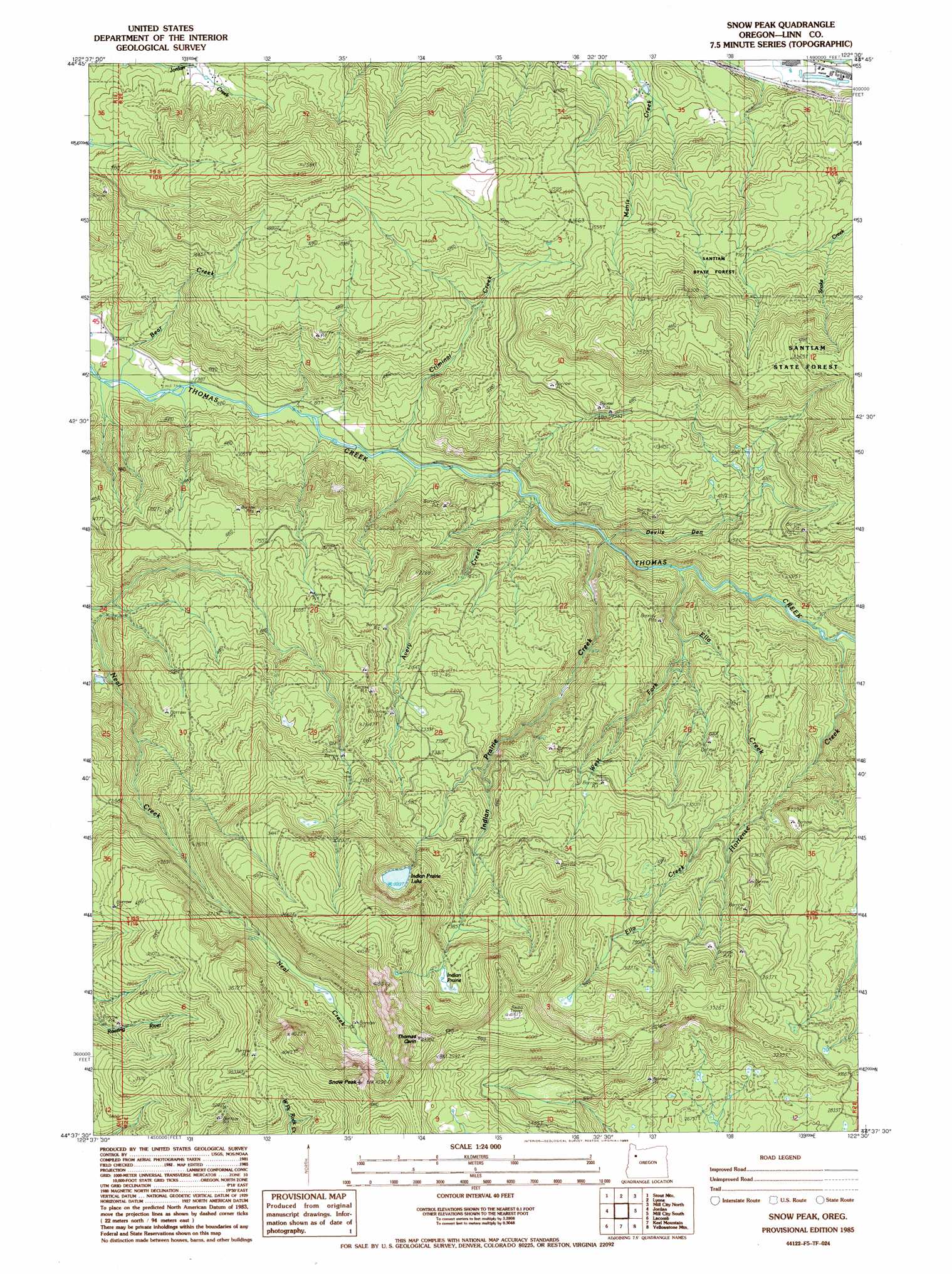
USGS Topo Quad 44122f5 - 1:24,000 scale
| Topo Map Name: | Snow Peak |
| USGS Topo Quad ID: | 44122f5 |
| Print Size: | ca. 21 1/4" wide x 27" high |
| Southeast Coordinates: | 44.625° N latitude / 122.5° W longitude |
| Map Center Coordinates: | 44.6875° N latitude / 122.5625° W longitude |
| U.S. State: | OR |
| Filename: | o44122f5.jpg |
| Download Map JPG Image: | Snow Peak topo map 1:24,000 scale |
| Map Type: | Topographic |
| Topo Series: | 7.5´ |
| Map Scale: | 1:24,000 |
| Source of Map Images: | United States Geological Survey (USGS) |
| Alternate Map Versions: |
Snow Peak OR 1985, updated 1985 Download PDF Buy paper map Snow Peak OR 2011 Download PDF Buy paper map Snow Peak OR 2014 Download PDF Buy paper map |
1:24,000 Topo Quads surrounding Snow Peak
Stayton Ne |
Drake Crossing |
Elk Prairie |
Gawley Creek |
Rooster Rock |
Stayton |
Stout Mountain |
Lyons |
Mill City North |
Elkhorn |
Scio |
Jordan |
Snow Peak |
Mill City South |
Lawhead Creek |
Onehorse Slough |
Lacomb |
Keel Mountain |
Yellowstone Mountain |
Quartzville |
Waterloo |
Sweet Home |
Green Peter |
Cascadia |
Upper Soda |
> Back to 44122e1 at 1:100,000 scale
> Back to 44122a1 at 1:250,000 scale
> Back to U.S. Topo Maps home
Snow Peak topo map: Gazetteer
Snow Peak: Flats
Indian Prairie elevation 1029m 3375′Snow Peak: Lakes
Indian Prairie Lake elevation 921m 3021′Snow Peak: Streams
Avery Creek elevation 278m 912′Bradshaw Creek elevation 249m 816′
Criminal Creek elevation 255m 836′
Ella Creek elevation 325m 1066′
Hortense Creek elevation 398m 1305′
Indian Prairie Creek elevation 292m 958′
West Fork Ella Creek elevation 384m 1259′
Snow Peak: Summits
Snow Peak elevation 1273m 4176′Snow Peak: Trails
Crabtree Lake Trail elevation 954m 3129′Snow Peak Mill City Trail elevation 1152m 3779′
Snow Peak: Valleys
Devils Den elevation 307m 1007′Snow Peak digital topo map on disk
Buy this Snow Peak topo map showing relief, roads, GPS coordinates and other geographical features, as a high-resolution digital map file on DVD: