Saint Jacques Topo Map Michigan
To zoom in, hover over the map of Saint Jacques
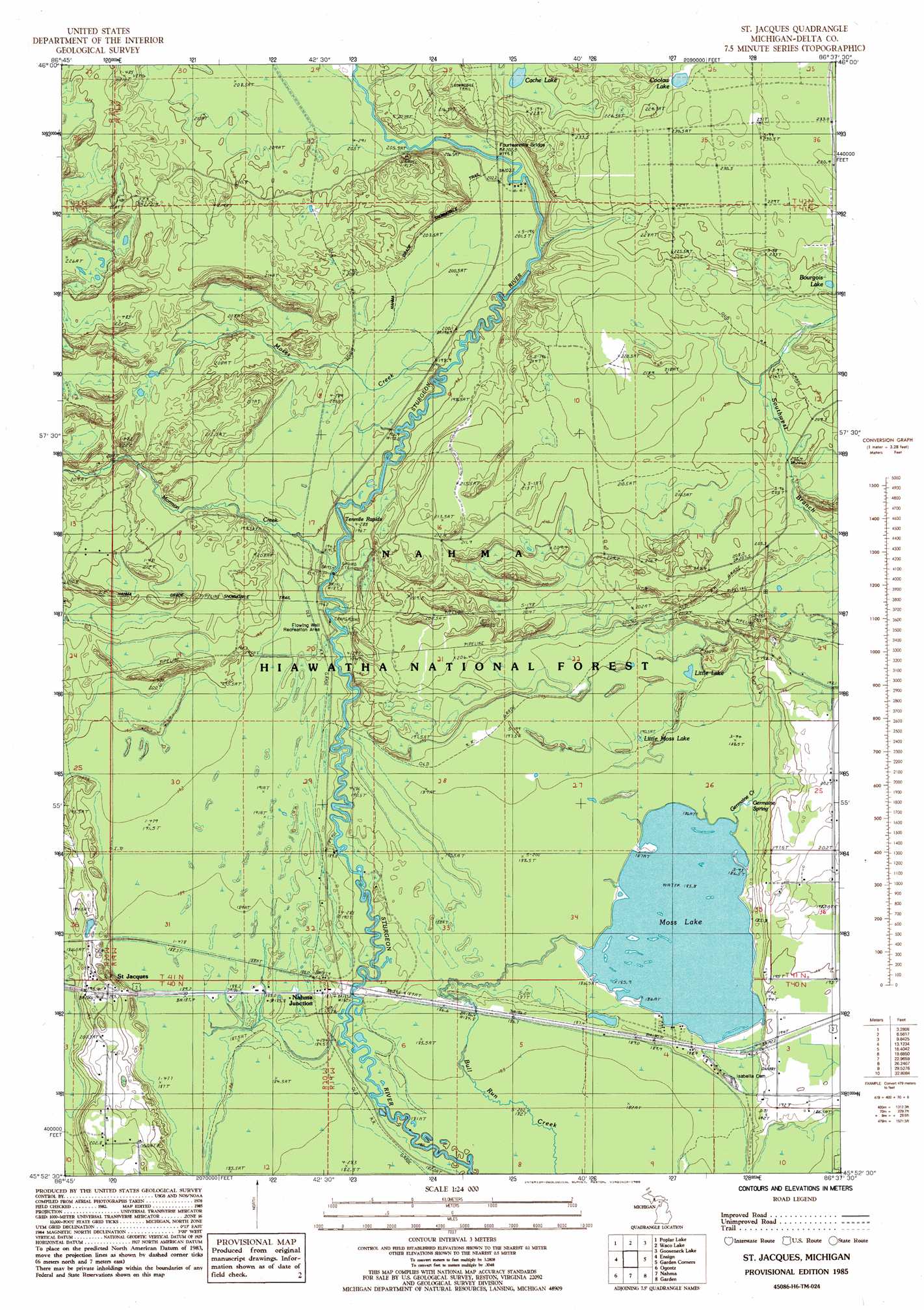
USGS Topo Quad 45086h6 - 1:24,000 scale
| Topo Map Name: | Saint Jacques |
| USGS Topo Quad ID: | 45086h6 |
| Print Size: | ca. 21 1/4" wide x 27" high |
| Southeast Coordinates: | 45.875° N latitude / 86.625° W longitude |
| Map Center Coordinates: | 45.9375° N latitude / 86.6875° W longitude |
| U.S. State: | MI |
| Filename: | o45086h6.jpg |
| Download Map JPG Image: | Saint Jacques topo map 1:24,000 scale |
| Map Type: | Topographic |
| Topo Series: | 7.5´ |
| Map Scale: | 1:24,000 |
| Source of Map Images: | United States Geological Survey (USGS) |
| Alternate Map Versions: |
St. Jacques MI 1985, updated 1985 Download PDF Buy paper map Saint Jacques MI 2011 Download PDF Buy paper map Saint Jacques MI 2014 Download PDF Buy paper map Saint Jacques MI 2016 Download PDF Buy paper map |
| FStopo: | US Forest Service topo Saint Jacques is available: Download FStopo PDF Download FStopo TIF |
1:24,000 Topo Quads surrounding Saint Jacques
Trenary |
Lake Stella |
The Lake |
Corner Lake |
Steuben |
Baker Creek |
Poplar Lake |
Waco Lake |
Gooseneck Lake |
Thunder Lake |
Rapid River |
Ensign |
Saint Jacques |
Garden Corners |
Cooks |
Maywood |
Ogontz |
Nahma |
Gardner |
Hiram Point |
Peninsula Point |
Chippewa Point |
Fayette |
Devils Corner |
> Back to 45086e1 at 1:100,000 scale
> Back to 45086a1 at 1:250,000 scale
> Back to U.S. Topo Maps home
Saint Jacques topo map: Gazetteer
Saint Jacques: Bridges
Fourteenmile Bridge elevation 200m 656′Saint Jacques: Lakes
Bourgois Lake elevation 217m 711′Cache Lake elevation 223m 731′
Coolaw Lakes elevation 228m 748′
Little Lake elevation 193m 633′
Little Moss Lake elevation 190m 623′
Moss Lake elevation 186m 610′
Saint Jacques: Populated Places
Nahma Junction elevation 189m 620′Saint Jacques elevation 199m 652′
Saint Jacques: Post Offices
Saint Joseph's Post Office (historical) elevation 198m 649′Saint Jacques: Rapids
Tenmile Rapids elevation 189m 620′Saint Jacques: Springs
Germaine Spring elevation 188m 616′Saint Jacques: Streams
Germaine Creek elevation 186m 610′Mormon Creek elevation 188m 616′
Moses Creek elevation 192m 629′
Tenmile Creek elevation 191m 626′
Saint Jacques: Wells
Flowing Well elevation 187m 613′Saint Jacques digital topo map on disk
Buy this Saint Jacques topo map showing relief, roads, GPS coordinates and other geographical features, as a high-resolution digital map file on DVD: