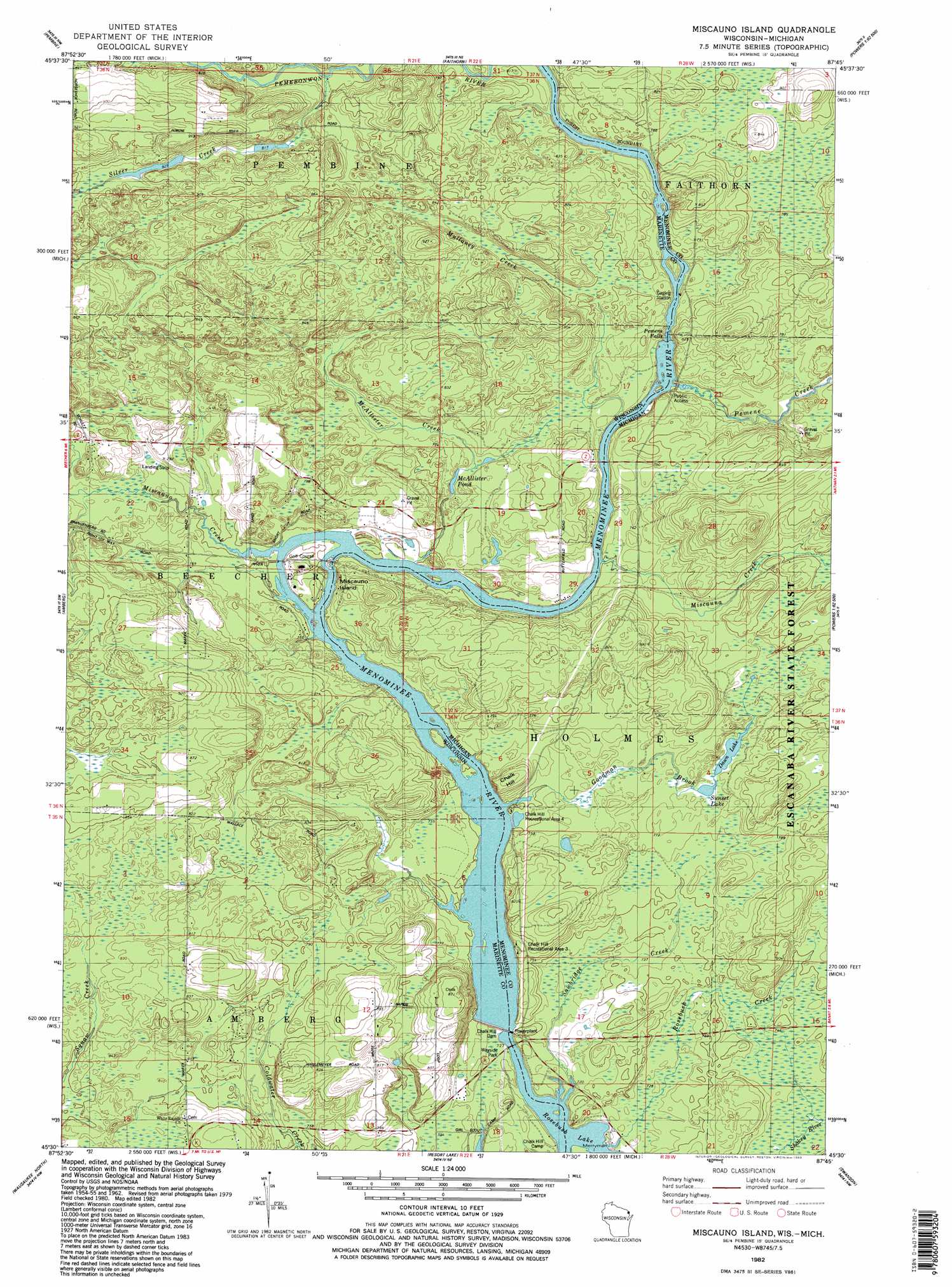
Miscauno Island Topo Map Wisconsin
To zoom in, hover over the map of Miscauno Island
USGS Topo Quad 45087e7 - 1:24,000 scale
| Topo Map Name: | Miscauno Island |
| USGS Topo Quad ID: | 45087e7 |
| Print Size: | ca. 21 1/4" wide x 27" high |
| Southeast Coordinates: | 45.5° N latitude / 87.75° W longitude |
| Map Center Coordinates: | 45.5625° N latitude / 87.8125° W longitude |
| U.S. States: | WI, MI |
| Filename: | o45087e7.jpg |
| Download Map JPG Image: | Miscauno Island topo map 1:24,000 scale |
| Map Type: | Topographic |
| Topo Series: | 7.5´ |
| Map Scale: | 1:24,000 |
| Source of Map Images: | United States Geological Survey (USGS) |
| Alternate Map Versions: |
Miscauno Island WI 1982, updated 1983 Download PDF Buy paper map Miscauno Island WI 2011 Download PDF Buy paper map Miscauno Island WI 2013 Download PDF Buy paper map Miscauno Island WI 2016 Download PDF Buy paper map |
1:24,000 Topo Quads surrounding Miscauno Island
Iron Mountain |
Norway |
Vulcan |
Waucedah |
Vega |
Dunbar Ne |
Pembine |
Faithorn |
Cunard |
Hermansville |
Town Corner Lake |
Amberg |
Miscauno Island |
Banat |
Nadeau |
Athelstane |
Wausaukee North |
Resort Lake |
Swanson |
Stephenson |
Mount Tom |
Wausaukee South |
Bear Point |
Mcallister |
Wallace |
> Back to 45087e1 at 1:100,000 scale
> Back to 45086a1 at 1:250,000 scale
> Back to U.S. Topo Maps home
Miscauno Island topo map: Gazetteer
Miscauno Island: Airports
Shangrila Airport elevation 253m 830′Miscauno Island: Bridges
Chalk Hill Bridge elevation 218m 715′Miscauno Island: Dams
Chalk Hill Dam elevation 218m 715′Chalk Hill Dam elevation 218m 715′
Miscauno Island: Falls
Pemene Falls elevation 231m 757′Pemene Falls elevation 227m 744′
Miscauno Island: Islands
Miscauno Island elevation 229m 751′Miscauno Island: Lakes
Dawn Lake elevation 233m 764′Sunset Lake elevation 234m 767′
Miscauno Island: Parks
Chalk Hill Recreational Area Four elevation 229m 751′Chalk Hill Recreational Area Three elevation 235m 770′
Miscauno Island: Populated Places
White Pine Haven elevation 232m 761′Miscauno Island: Reservoirs
McAllister Pond elevation 230m 754′Miscauno Island: Streams
Goodman Brook elevation 228m 748′McAllister Creek elevation 227m 744′
Miscauna Creek elevation 228m 748′
Miscauno Creek elevation 227m 744′
Mullaney Creek elevation 227m 744′
Pemene Creek elevation 228m 748′
Sawbridge Creek elevation 221m 725′
Silver Creek elevation 242m 793′
Miscauno Island: Summits
Chalk Hill elevation 253m 830′Miscauno Island digital topo map on disk
Buy this Miscauno Island topo map showing relief, roads, GPS coordinates and other geographical features, as a high-resolution digital map file on DVD: