Phillipi Reservoir Topo Map Montana
To zoom in, hover over the map of Phillipi Reservoir
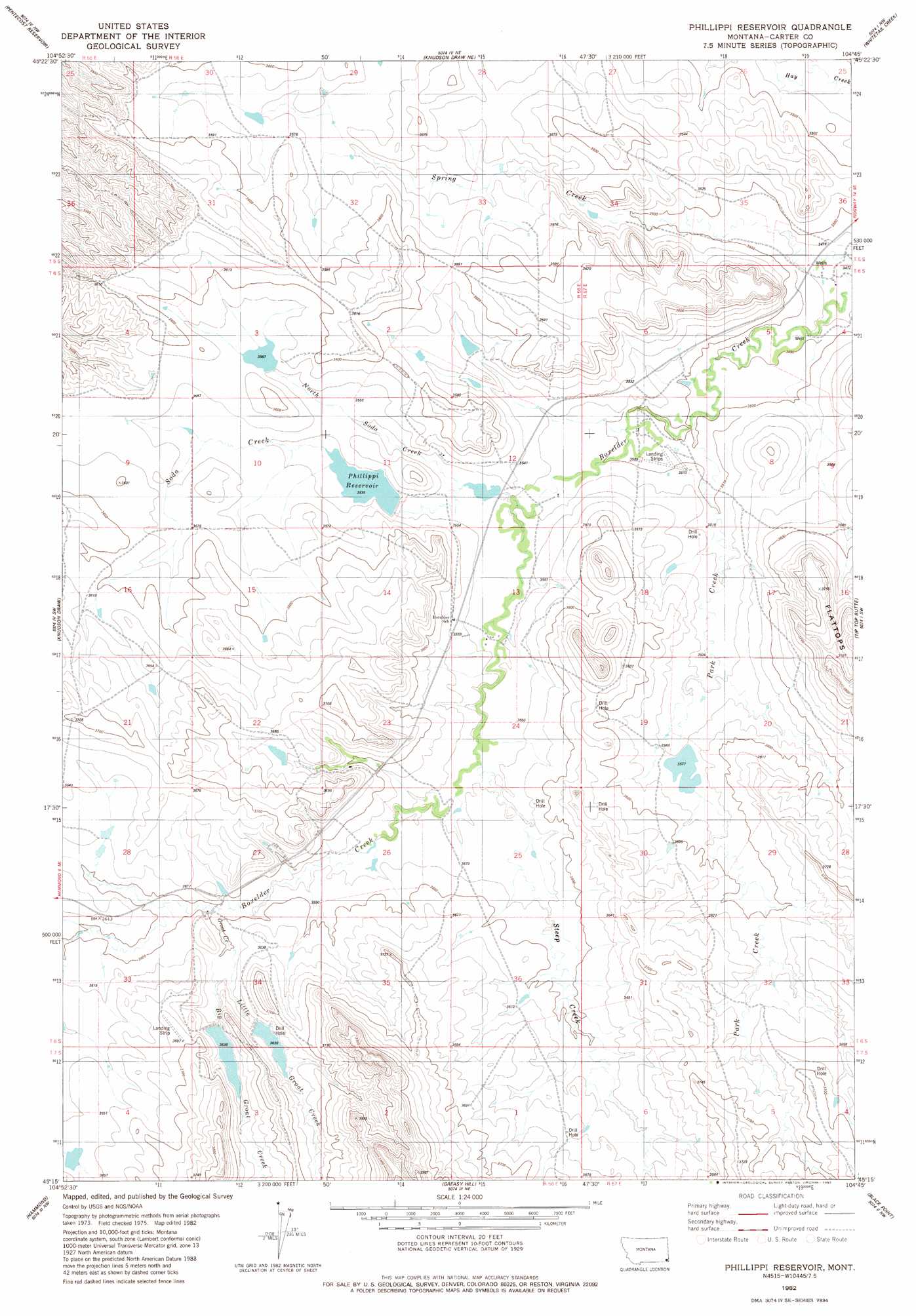
USGS Topo Quad 45104c7 - 1:24,000 scale
| Topo Map Name: | Phillipi Reservoir |
| USGS Topo Quad ID: | 45104c7 |
| Print Size: | ca. 21 1/4" wide x 27" high |
| Southeast Coordinates: | 45.25° N latitude / 104.75° W longitude |
| Map Center Coordinates: | 45.3125° N latitude / 104.8125° W longitude |
| U.S. State: | MT |
| Filename: | o45104c7.jpg |
| Download Map JPG Image: | Phillipi Reservoir topo map 1:24,000 scale |
| Map Type: | Topographic |
| Topo Series: | 7.5´ |
| Map Scale: | 1:24,000 |
| Source of Map Images: | United States Geological Survey (USGS) |
| Alternate Map Versions: |
Phillippi Reservoir MT 1982, updated 1982 Download PDF Buy paper map Phillippi Reservoir MT 2011 Download PDF Buy paper map Phillippi Reservoir MT 2014 Download PDF Buy paper map |
1:24,000 Topo Quads surrounding Phillipi Reservoir
Mckenzie Creek |
Pocochichee Butte |
W L Butte |
Dutchman Creek |
Ikey Creek |
Lightning Butte |
Pentecost Reservoir |
Knudson Draw Ne |
Whitetail Creek |
Ridgway |
Boyes |
Knudson Draw |
Phillipi Reservoir |
Tip Top Butte |
Potato Buttes |
Belle Creek North |
Hammond |
Greasy Hill |
Black Point |
Black Point Ne |
Belle Creek South |
Stack Rocks |
Hammond Se |
Cochran Reservoir |
Gomer Draw |
> Back to 45104a1 at 1:100,000 scale
> Back to 45104a1 at 1:250,000 scale
> Back to U.S. Topo Maps home
Phillipi Reservoir topo map: Gazetteer
Phillipi Reservoir: Airports
Gardner Airport elevation 1124m 3687′Phillipi Reservoir: Dams
Brownfield Dam elevation 1091m 3579′Bum Lamb Dam elevation 1092m 3582′
Gardner Number 2 Dam elevation 1110m 3641′
La Ze Number 1 Dam elevation 1123m 3684′
Marys Lamb Dam elevation 1086m 3562′
Phillippi Number 1 Dam elevation 1076m 3530′
Soda Creek Dam elevation 1079m 3540′
Phillipi Reservoir: Reservoirs
Phillippi Reservoir elevation 1078m 3536′Phillipi Reservoir: Streams
Big Groat Creek elevation 1101m 3612′Groat Creek elevation 1099m 3605′
Little Groat Creek elevation 1101m 3612′
North Soda Creek elevation 1076m 3530′
Park Creek elevation 1068m 3503′
Soda Creek elevation 1074m 3523′
Spring Creek elevation 1058m 3471′
Steep Creek elevation 1080m 3543′
Phillipi Reservoir digital topo map on disk
Buy this Phillipi Reservoir topo map showing relief, roads, GPS coordinates and other geographical features, as a high-resolution digital map file on DVD:
Eastern Montana & Western North Dakota
Buy digital topo maps: Eastern Montana & Western North Dakota