Pendleton Topo Map Oregon
To zoom in, hover over the map of Pendleton
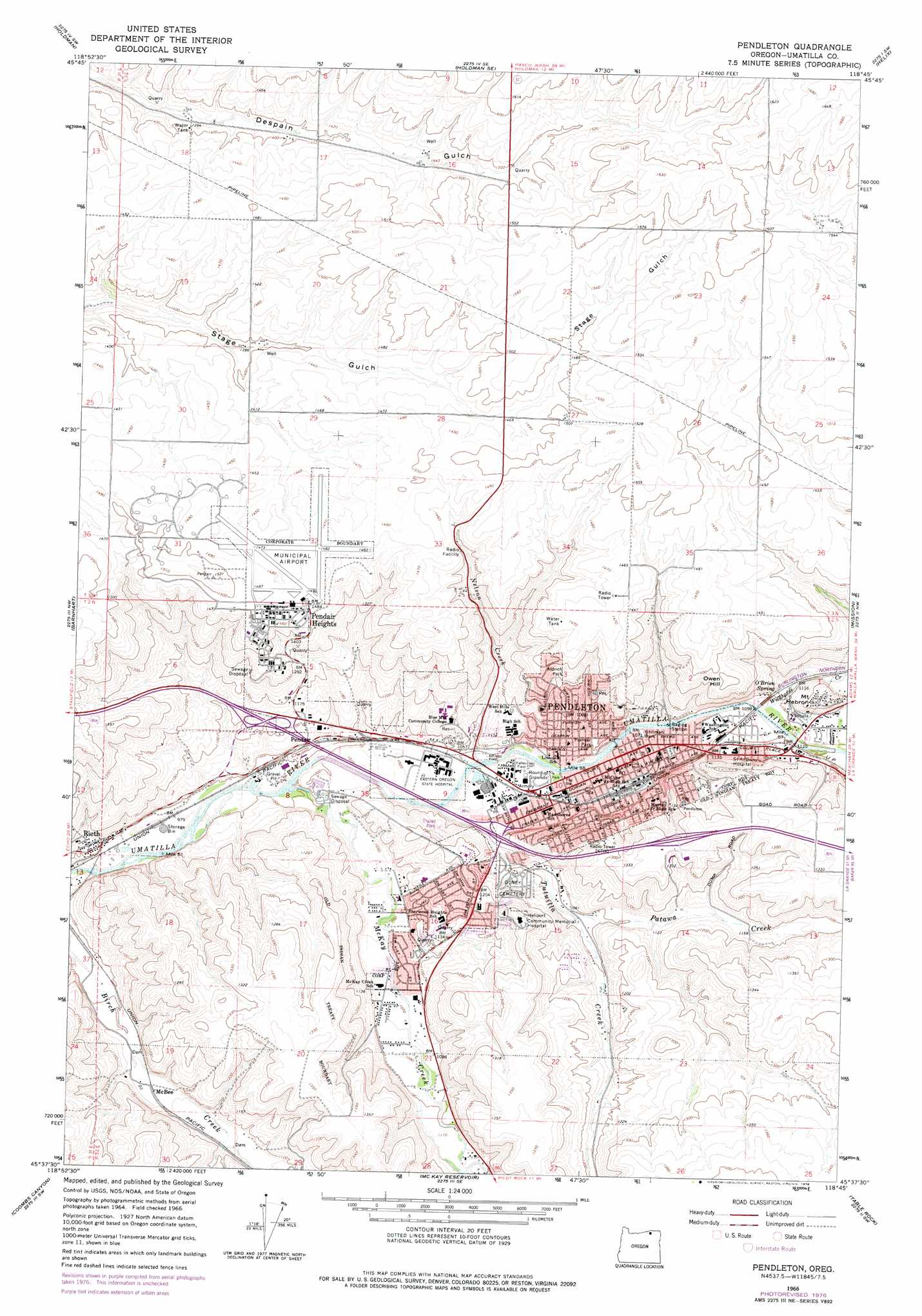
USGS Topo Quad 45118f7 - 1:24,000 scale
| Topo Map Name: | Pendleton |
| USGS Topo Quad ID: | 45118f7 |
| Print Size: | ca. 21 1/4" wide x 27" high |
| Southeast Coordinates: | 45.625° N latitude / 118.75° W longitude |
| Map Center Coordinates: | 45.6875° N latitude / 118.8125° W longitude |
| U.S. State: | OR |
| Filename: | o45118f7.jpg |
| Download Map JPG Image: | Pendleton topo map 1:24,000 scale |
| Map Type: | Topographic |
| Topo Series: | 7.5´ |
| Map Scale: | 1:24,000 |
| Source of Map Images: | United States Geological Survey (USGS) |
| Alternate Map Versions: |
Pendleton OR 1966, updated 1967 Download PDF Buy paper map Pendleton OR 1966, updated 1978 Download PDF Buy paper map Pendleton OR 1966, updated 1978 Download PDF Buy paper map Pendleton OR 2011 Download PDF Buy paper map Pendleton OR 2014 Download PDF Buy paper map |
1:24,000 Topo Quads surrounding Pendleton
Juniper |
Juniper Canyon |
Ring |
Smeltz |
Waterman |
Stanfield Se |
Holdman |
Holdman Se |
Helix |
Adams |
Nolin |
Barnhart |
Pendleton |
Mission |
Cayuse |
Echo Se |
Coombs Canyon |
Mckay Reservoir |
Table Rock |
Cabbage Hill |
Vinson |
Nye |
Pilot Rock |
Sevenmile Creek |
Bassey Creek |
> Back to 45118e1 at 1:100,000 scale
> Back to 45118a1 at 1:250,000 scale
> Back to U.S. Topo Maps home
Pendleton topo map: Gazetteer
Pendleton: Airports
Pendleton Community Hospital Helipad elevation 394m 1292′Pendleton Municipal Airport elevation 451m 1479′
Pendleton: Parks
Aldrich Park elevation 395m 1295′Centennial Park elevation 327m 1072′
Community Park elevation 321m 1053′
Fallen Field elevation 319m 1046′
Grecian Heights Park elevation 337m 1105′
Kiwanis Park elevation 335m 1099′
May Park elevation 359m 1177′
McKay School Park elevation 326m 1069′
Pendair Park elevation 422m 1384′
Pendleton Community Park elevation 355m 1164′
Pioneer Park elevation 337m 1105′
Rice-Blakey Park elevation 386m 1266′
River Parkway elevation 334m 1095′
Roy Raley Park elevation 322m 1056′
Sergeant City Park elevation 369m 1210′
Sherwood Park elevation 369m 1210′
Stillman Park elevation 327m 1072′
Till Taylor Park elevation 329m 1079′
Vincent Park elevation 400m 1312′
Pendleton: Populated Places
Glendale elevation 328m 1076′Pendair Heights elevation 449m 1473′
Pendleton elevation 325m 1066′
Rieth elevation 307m 1007′
Pendleton: Post Offices
Pendleton Field Post Office (historical) elevation 455m 1492′Pendleton Post Office elevation 316m 1036′
Rieth Post Office (historical) elevation 307m 1007′
Pendleton: Springs
O'Brien Spring elevation 352m 1154′Pendleton: Streams
McKay Creek elevation 302m 990′Nelson Creek elevation 318m 1043′
Patawa Creek elevation 330m 1082′
Tutuilla Creek elevation 312m 1023′
Wildhorse Creek elevation 331m 1085′
Pendleton: Summits
Owen Hill elevation 429m 1407′Pendleton digital topo map on disk
Buy this Pendleton topo map showing relief, roads, GPS coordinates and other geographical features, as a high-resolution digital map file on DVD: