Vinson Topo Map Oregon
To zoom in, hover over the map of Vinson
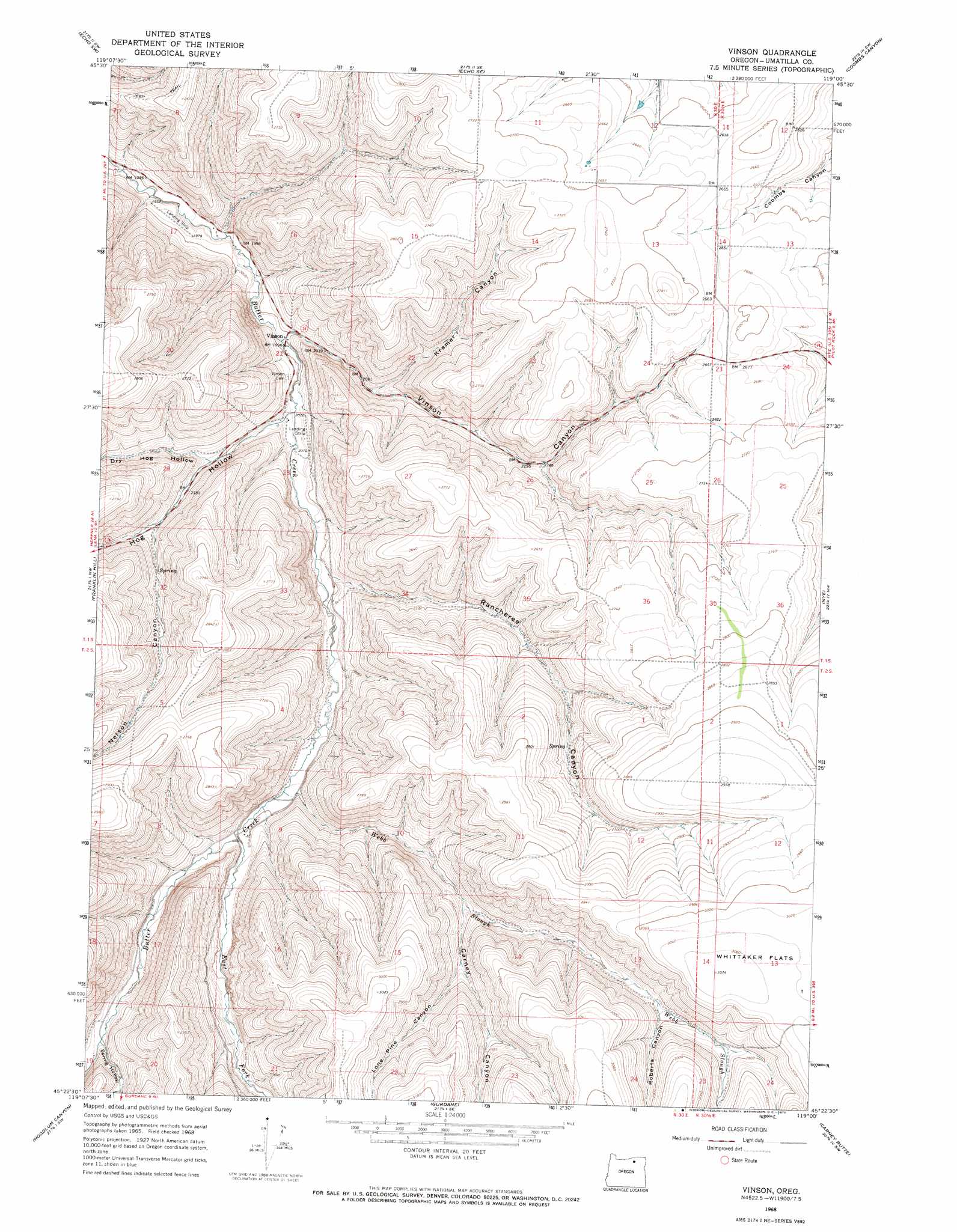
USGS Topo Quad 45119d1 - 1:24,000 scale
| Topo Map Name: | Vinson |
| USGS Topo Quad ID: | 45119d1 |
| Print Size: | ca. 21 1/4" wide x 27" high |
| Southeast Coordinates: | 45.375° N latitude / 119° W longitude |
| Map Center Coordinates: | 45.4375° N latitude / 119.0625° W longitude |
| U.S. State: | OR |
| Filename: | o45119d1.jpg |
| Download Map JPG Image: | Vinson topo map 1:24,000 scale |
| Map Type: | Topographic |
| Topo Series: | 7.5´ |
| Map Scale: | 1:24,000 |
| Source of Map Images: | United States Geological Survey (USGS) |
| Alternate Map Versions: |
Vinson OR 1968, updated 1970 Download PDF Buy paper map Vinson OR 2011 Download PDF Buy paper map Vinson OR 2014 Download PDF Buy paper map |
1:24,000 Topo Quads surrounding Vinson
Service Buttes |
Echo |
Nolin |
Barnhart |
Pendleton |
Vey Ranch |
Echo Sw |
Echo Se |
Coombs Canyon |
Mckay Reservoir |
Lena |
Franklin Hill |
Vinson |
Nye |
Pilot Rock |
Freezeout Ridge |
Hoodlum Canyon |
Gurdane |
Carney Butte |
Granite Meadows |
Arbuckle Mountain |
Matlock Prairie |
Sugarbowl Creek |
Ukiah |
Owens Butte |
> Back to 45119a1 at 1:100,000 scale
> Back to 45118a1 at 1:250,000 scale
> Back to U.S. Topo Maps home
Vinson topo map: Gazetteer
Vinson: Post Offices
Evarts Post Office (historical) elevation 841m 2759′Vinson Post Office (historical) elevation 606m 1988′
Vinson: Streams
East Fork Butter Creek elevation 671m 2201′Webb Slough elevation 666m 2185′
Vinson: Valleys
Carney Canyon elevation 739m 2424′Dry Hog Hollow elevation 644m 2112′
Hog Hollow elevation 616m 2020′
Kramer Canyon elevation 643m 2109′
Lone Pine Canyon elevation 770m 2526′
Nelson Canyon elevation 680m 2230′
Rancheree Canyon elevation 632m 2073′
Roberts Canyon elevation 815m 2673′
Spring Hollow elevation 718m 2355′
Vinson Canyon elevation 604m 1981′
Vinson digital topo map on disk
Buy this Vinson topo map showing relief, roads, GPS coordinates and other geographical features, as a high-resolution digital map file on DVD: