Flag Point Topo Map Oregon
To zoom in, hover over the map of Flag Point
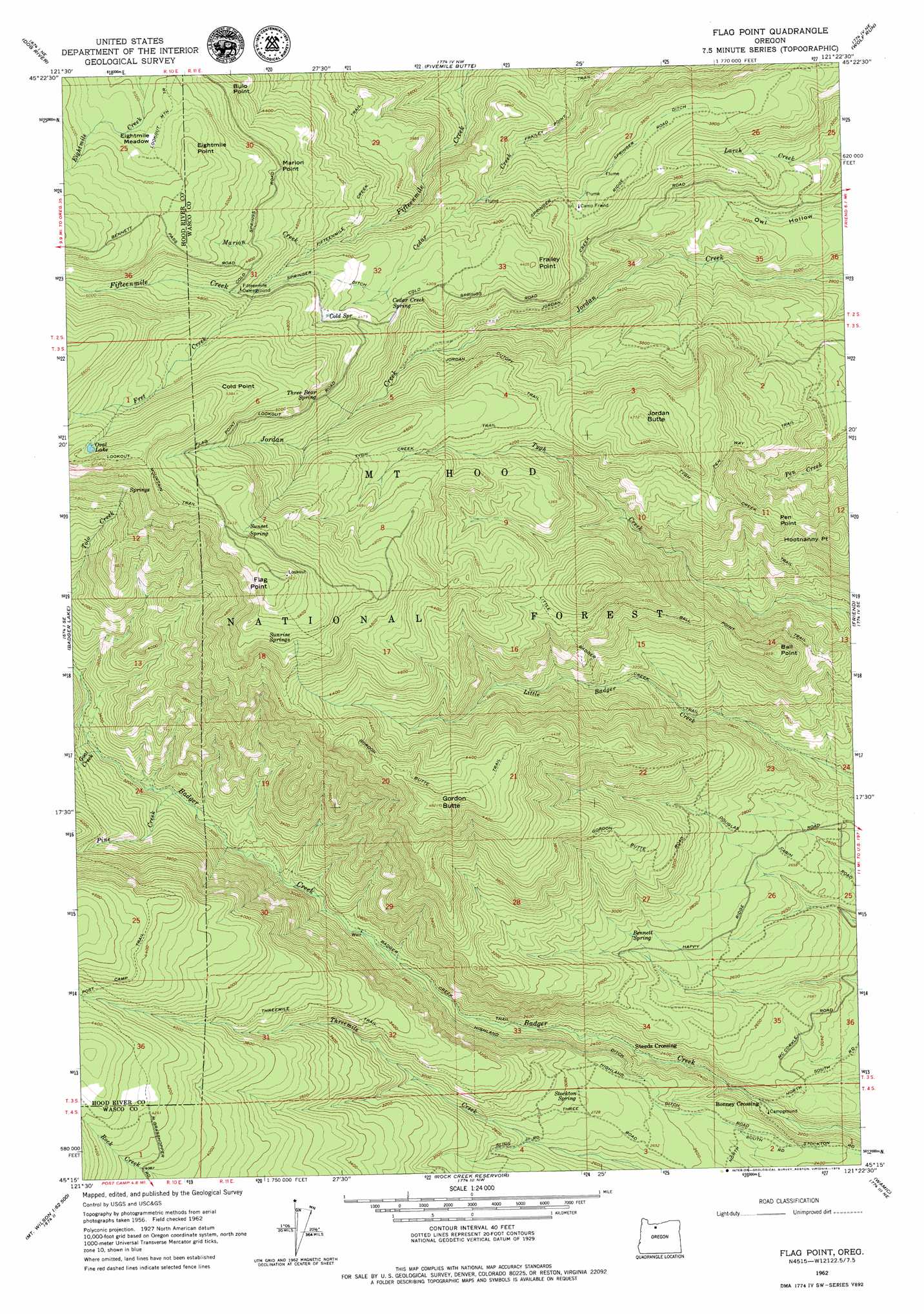
USGS Topo Quad 45121c4 - 1:24,000 scale
| Topo Map Name: | Flag Point |
| USGS Topo Quad ID: | 45121c4 |
| Print Size: | ca. 21 1/4" wide x 27" high |
| Southeast Coordinates: | 45.25° N latitude / 121.375° W longitude |
| Map Center Coordinates: | 45.3125° N latitude / 121.4375° W longitude |
| U.S. State: | OR |
| Filename: | o45121c4.jpg |
| Download Map JPG Image: | Flag Point topo map 1:24,000 scale |
| Map Type: | Topographic |
| Topo Series: | 7.5´ |
| Map Scale: | 1:24,000 |
| Source of Map Images: | United States Geological Survey (USGS) |
| Alternate Map Versions: |
Flag Point OR 1962, updated 1964 Download PDF Buy paper map Flag Point OR 1996, updated 1998 Download PDF Buy paper map Flag Point OR 2011 Download PDF Buy paper map Flag Point OR 2014 Download PDF Buy paper map |
| FStopo: | US Forest Service topo Flag Point is available: Download FStopo PDF Download FStopo TIF |
1:24,000 Topo Quads surrounding Flag Point
Dee |
Parkdale |
Ketchum Reservoir |
Brown Creek |
The Dalles South |
Mount Hood North |
Dog River |
Fivemile Butte |
Wolf Run |
Dufur West |
Mount Hood South |
Badger Lake |
Flag Point |
Friend |
Postage Stamp Butte |
Wapinitia Pass |
Post Point |
Rock Creek Reservoir |
Wamic |
Tygh Valley |
Mount Wilson |
Beaver Butte |
Foreman Point |
Wapinitia |
Maupin Sw |
> Back to 45121a1 at 1:100,000 scale
> Back to 45120a1 at 1:250,000 scale
> Back to U.S. Topo Maps home
Flag Point topo map: Gazetteer
Flag Point: Canals
Springer Ditch elevation 1367m 4484′Flag Point: Capes
Bulo Point elevation 1456m 4776′Flag Point elevation 1722m 5649′
Flag Point: Flats
Eightmile Meadow elevation 1543m 5062′Flag Point: Lakes
Oval Lake elevation 1691m 5547′Flag Point: Ridges
Springer Ridge elevation 1055m 3461′Flag Point: Springs
Bennett Spring elevation 857m 2811′Bird Spring elevation 1473m 4832′
Cedar Creek Spring elevation 1328m 4356′
Cold Spring elevation 1371m 4498′
Denest Spring elevation 1465m 4806′
Stockton Spring elevation 843m 2765′
Sunrise Springs elevation 1592m 5223′
Sunset Spring elevation 1641m 5383′
Three Bear Spring elevation 1438m 4717′
Flag Point: Streams
Drop Creek elevation 976m 3202′Fret Creek elevation 1381m 4530′
Goat Creek elevation 968m 3175′
Marion Creek elevation 1311m 4301′
Pine Creek elevation 926m 3038′
Flag Point: Summits
Ball Point elevation 1193m 3914′Cold Point elevation 1637m 5370′
Eightmile Point elevation 1600m 5249′
Frailey Point elevation 1340m 4396′
Gordon Butte elevation 1463m 4799′
Hootnanny Point elevation 1228m 4028′
Jordan Butte elevation 1453m 4767′
Marion Point elevation 1463m 4799′
Pen Point elevation 1199m 3933′
Flag Point: Trails
Badger Creek Trail elevation 786m 2578′Ball Point Trail elevation 1119m 3671′
Frailey Point Trail elevation 1062m 3484′
Gordon Butte Trail elevation 1406m 4612′
Jordan Cutoff Trail elevation 1302m 4271′
Little Badger Creek Trail elevation 895m 2936′
Pen Way Trail elevation 1209m 3966′
Threemile Trail elevation 1141m 3743′
Tygh Creek Trail elevation 1339m 4393′
Flag Point digital topo map on disk
Buy this Flag Point topo map showing relief, roads, GPS coordinates and other geographical features, as a high-resolution digital map file on DVD: