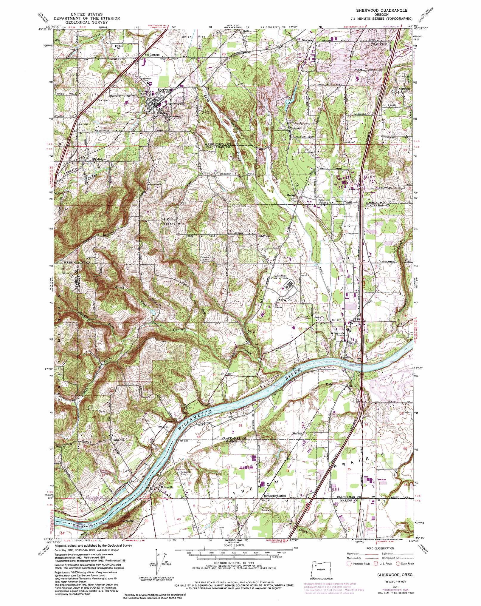
Sherwood Topo Map Oregon
To zoom in, hover over the map of Sherwood
USGS Topo Quad 45122c7 - 1:24,000 scale
| Topo Map Name: | Sherwood |
| USGS Topo Quad ID: | 45122c7 |
| Print Size: | ca. 21 1/4" wide x 27" high |
| Southeast Coordinates: | 45.25° N latitude / 122.75° W longitude |
| Map Center Coordinates: | 45.3125° N latitude / 122.8125° W longitude |
| U.S. State: | OR |
| Filename: | o45122c7.jpg |
| Download Map JPG Image: | Sherwood topo map 1:24,000 scale |
| Map Type: | Topographic |
| Topo Series: | 7.5´ |
| Map Scale: | 1:24,000 |
| Source of Map Images: | United States Geological Survey (USGS) |
| Alternate Map Versions: |
Sherwood OR 1954, updated 1957 Download PDF Buy paper map Sherwood OR 1961, updated 1961 Download PDF Buy paper map Sherwood OR 1961, updated 1971 Download PDF Buy paper map Sherwood OR 1961, updated 1977 Download PDF Buy paper map Sherwood OR 1961, updated 1985 Download PDF Buy paper map Sherwood OR 1961, updated 1991 Download PDF Buy paper map Sherwood OR 2011 Download PDF Buy paper map Sherwood OR 2014 Download PDF Buy paper map |
1:24,000 Topo Quads surrounding Sherwood
Forest Grove |
Hillsboro |
Linnton |
Portland |
Mount Tabor |
Laurelwood |
Scholls |
Beaverton |
Lake Oswego |
Gladstone |
Dundee |
Newberg |
Sherwood |
Canby |
Oregon City |
Dayton |
Saint Paul |
Woodburn |
Yoder |
Molalla |
Mission Bottom |
Gervais |
Silverton |
Scotts Mills |
Wilhoit |
> Back to 45122a1 at 1:100,000 scale
> Back to 45122a1 at 1:250,000 scale
> Back to U.S. Topo Maps home
Sherwood topo map: Gazetteer
Sherwood: Airports
Aurora State Airport elevation 60m 196′Sherwood: Areas
Tonquin Scablands elevation 50m 164′Sherwood: Canals
Seely Ditch elevation 44m 144′Sherwood: Crossings
Interchange 283 elevation 50m 164′Interchange 286 elevation 79m 259′
Interchange 288 elevation 70m 229′
Sherwood: Dams
Joseph Rogers Dam elevation 36m 118′Sherwood: Lakes
Murrays Pond elevation 45m 147′Timothy Lake elevation 74m 242′
Sherwood: Parks
Boones Ferry City Park elevation 37m 121′Boones Ferry County Boat Launch elevation 34m 111′
Cinnamon Hills City Park elevation 84m 275′
Coffee Lake Park elevation 45m 147′
Community Campus Park elevation 62m 203′
Courtside City Park elevation 59m 193′
Hathaway City Park elevation 50m 164′
Ibach City Park elevation 76m 249′
Lady Fern City Park elevation 53m 173′
Lafky City Park elevation 68m 223′
Langer City Park elevation 66m 216′
Little Woodrose Natural Area elevation 76m 249′
Memorial City Park elevation 29m 95′
Montebello City Park elevation 48m 157′
Murdock City Park elevation 81m 265′
Oregon Trail City Park elevation 56m 183′
Park at Merryfield elevation 61m 200′
Pioneer City Park elevation 63m 206′
River Fox City Park elevation 56m 183′
Saarinen Wayside Park elevation 73m 239′
Stella Olsen City Park elevation 64m 209′
Sunset City Park elevation 68m 223′
Town Center City Park elevation 56m 183′
Tranquil City Park elevation 58m 190′
Veterans Memorial City Park elevation 60m 196′
Victoria Woods Natural Area elevation 108m 354′
Wiedeman City Park elevation 71m 232′
Woodhaven City Park elevation 73m 239′
Sherwood: Populated Places
Butteville elevation 42m 137′Charbonneau elevation 43m 141′
Hoodview elevation 103m 337′
Ladd Hill elevation 103m 337′
Middleton elevation 66m 216′
Mulloy elevation 65m 213′
Norwood elevation 93m 305′
Sherwood elevation 60m 196′
Six Corners elevation 64m 209′
Wilsonville elevation 47m 154′
Sherwood: Post Offices
Boon Post Office (historical) elevation 53m 173′Butteville Post Office (historical) elevation 42m 137′
Graeme Post Office (historical) elevation 44m 144′
Middleton Post Office (historical) elevation 66m 216′
Sherwood Post Office elevation 60m 196′
Tonquin Post Office (historical) elevation 74m 242′
Wallamette Post Office (historical) elevation 25m 82′
Wilsonville Post Office elevation 47m 154′
Yam Hill Post Office (historical) elevation 34m 111′
Sherwood: Reservoirs
Brookforest Pond elevation 83m 272′Joseph Rogers Reservoir elevation 36m 118′
Loewen Reservoir elevation 96m 314′
Nuffer Reservoir elevation 49m 160′
Richter Pond elevation 82m 269′
Tualatin Reservoir elevation 60m 196′
Sherwood: Springs
Krause Springs elevation 47m 154′Sherwood: Streams
Boeckman Creek elevation 24m 78′Cedar Creek elevation 41m 134′
Coffee Lake Creek elevation 25m 82′
Corral Creek elevation 18m 59′
Goose Creek elevation 54m 177′
Jim Tapman Creek elevation 20m 65′
Loewen Creek elevation 235m 770′
Middle Fork Corral Creek elevation 72m 236′
Mill Creek elevation 35m 114′
North Fork Corral Creek elevation 53m 173′
Ryan Creek elevation 18m 59′
South Fork Corral Creek elevation 75m 246′
Tapman Creek elevation 80m 262′
West Fork Chicken Creek elevation 45m 147′
Sherwood: Summits
La Butte elevation 133m 436′Pleasant Hill elevation 186m 610′
Sherwood digital topo map on disk
Buy this Sherwood topo map showing relief, roads, GPS coordinates and other geographical features, as a high-resolution digital map file on DVD: