Gumboot Mountain Topo Map Washington
To zoom in, hover over the map of Gumboot Mountain
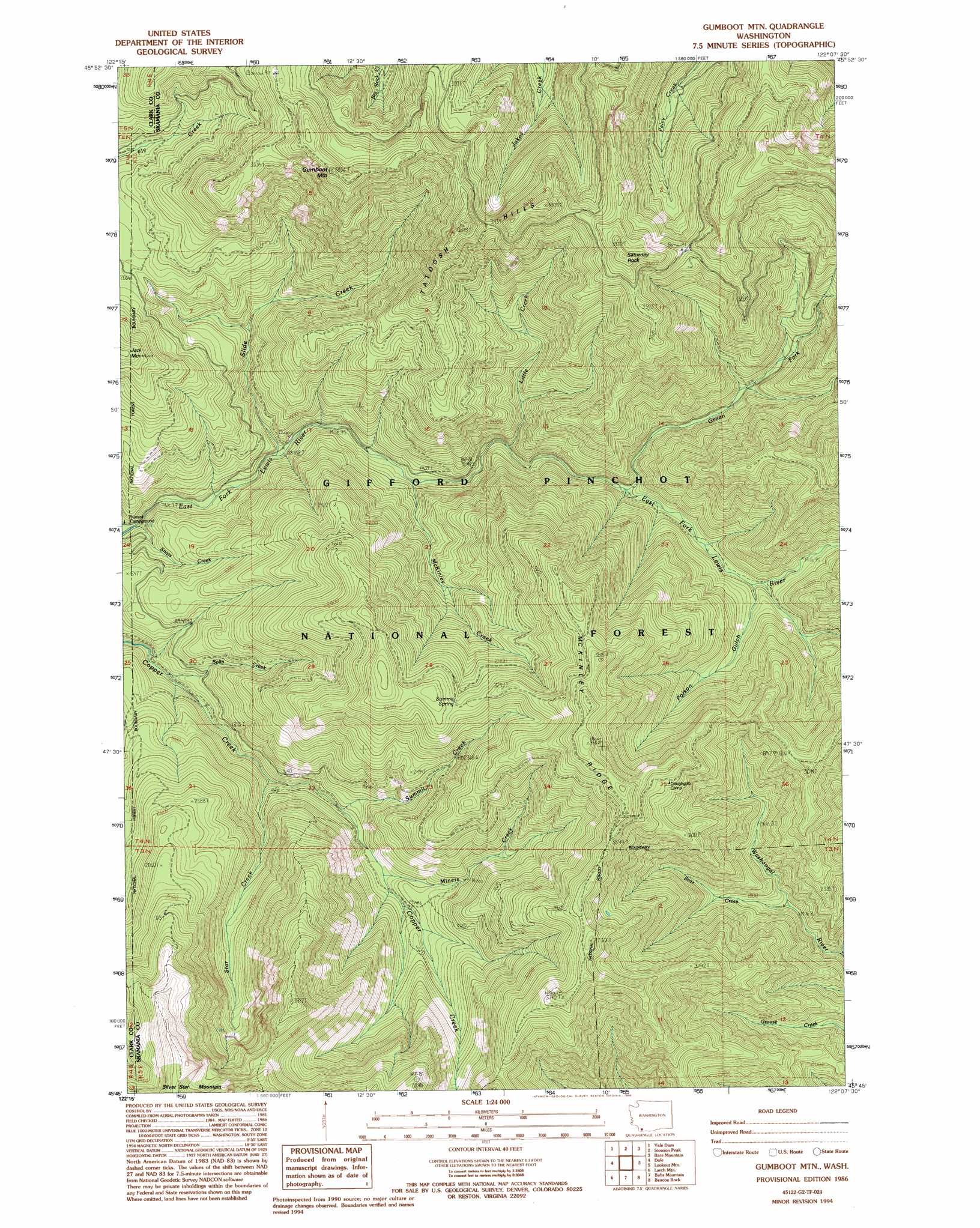
USGS Topo Quad 45122g2 - 1:24,000 scale
| Topo Map Name: | Gumboot Mountain |
| USGS Topo Quad ID: | 45122g2 |
| Print Size: | ca. 21 1/4" wide x 27" high |
| Southeast Coordinates: | 45.75° N latitude / 122.125° W longitude |
| Map Center Coordinates: | 45.8125° N latitude / 122.1875° W longitude |
| U.S. State: | WA |
| Filename: | o45122g2.jpg |
| Download Map JPG Image: | Gumboot Mountain topo map 1:24,000 scale |
| Map Type: | Topographic |
| Topo Series: | 7.5´ |
| Map Scale: | 1:24,000 |
| Source of Map Images: | United States Geological Survey (USGS) |
| Alternate Map Versions: |
Gumboot Mtn WA 1986, updated 1986 Download PDF Buy paper map Gumboot Mtn WA 1986, updated 1994 Download PDF Buy paper map Gumboot Mountain WA 1998, updated 2003 Download PDF Buy paper map Gumboot Mountain WA 2011 Download PDF Buy paper map Gumboot Mountain WA 2013 Download PDF Buy paper map |
| FStopo: | US Forest Service topo Gumboot Mountain is available: Download FStopo PDF Download FStopo TIF |
1:24,000 Topo Quads surrounding Gumboot Mountain
Lakeview Peak |
Cougar |
Mount Mitchell |
Cedar Flats |
Burnt Peak |
Amboy |
Yale Dam |
Siouxon Peak |
Bare Mountain |
Termination Point |
Yacolt |
Dole |
Gumboot Mountain |
Lookout Mountain |
Stabler |
Lacamas Creek |
Larch Mountain |
Bobs Mountain |
Beacon Rock |
Bonneville Dam |
Camas |
Washougal |
Bridal Veil |
Multnomah Falls |
Tanner Butte |
> Back to 45122e1 at 1:100,000 scale
> Back to 45122a1 at 1:250,000 scale
> Back to U.S. Topo Maps home
Gumboot Mountain topo map: Gazetteer
Gumboot Mountain: Ridges
McKinley Ridge elevation 1203m 3946′Gumboot Mountain: Springs
Summit Spring elevation 948m 3110′Gumboot Mountain: Streams
Bear Creek elevation 485m 1591′Bolin Creek elevation 358m 1174′
Green Fork elevation 487m 1597′
Little Creek elevation 439m 1440′
Lookout Creek elevation 472m 1548′
McKinley Creek elevation 394m 1292′
Miners Creek elevation 513m 1683′
Slide Creek elevation 346m 1135′
Star Creek elevation 417m 1368′
Summit Creek elevation 474m 1555′
Gumboot Mountain: Summits
Gumboot Mountain elevation 1159m 3802′Saturday Rock elevation 1183m 3881′
Tatoosh Hills elevation 1036m 3398′
Gumboot Mountain: Trails
Washougal Trail elevation 580m 1902′Gumboot Mountain: Valleys
Poison Gulch elevation 562m 1843′Gumboot Mountain digital topo map on disk
Buy this Gumboot Mountain topo map showing relief, roads, GPS coordinates and other geographical features, as a high-resolution digital map file on DVD: