Squa Pan Lake East Topo Map Maine
To zoom in, hover over the map of Squa Pan Lake East
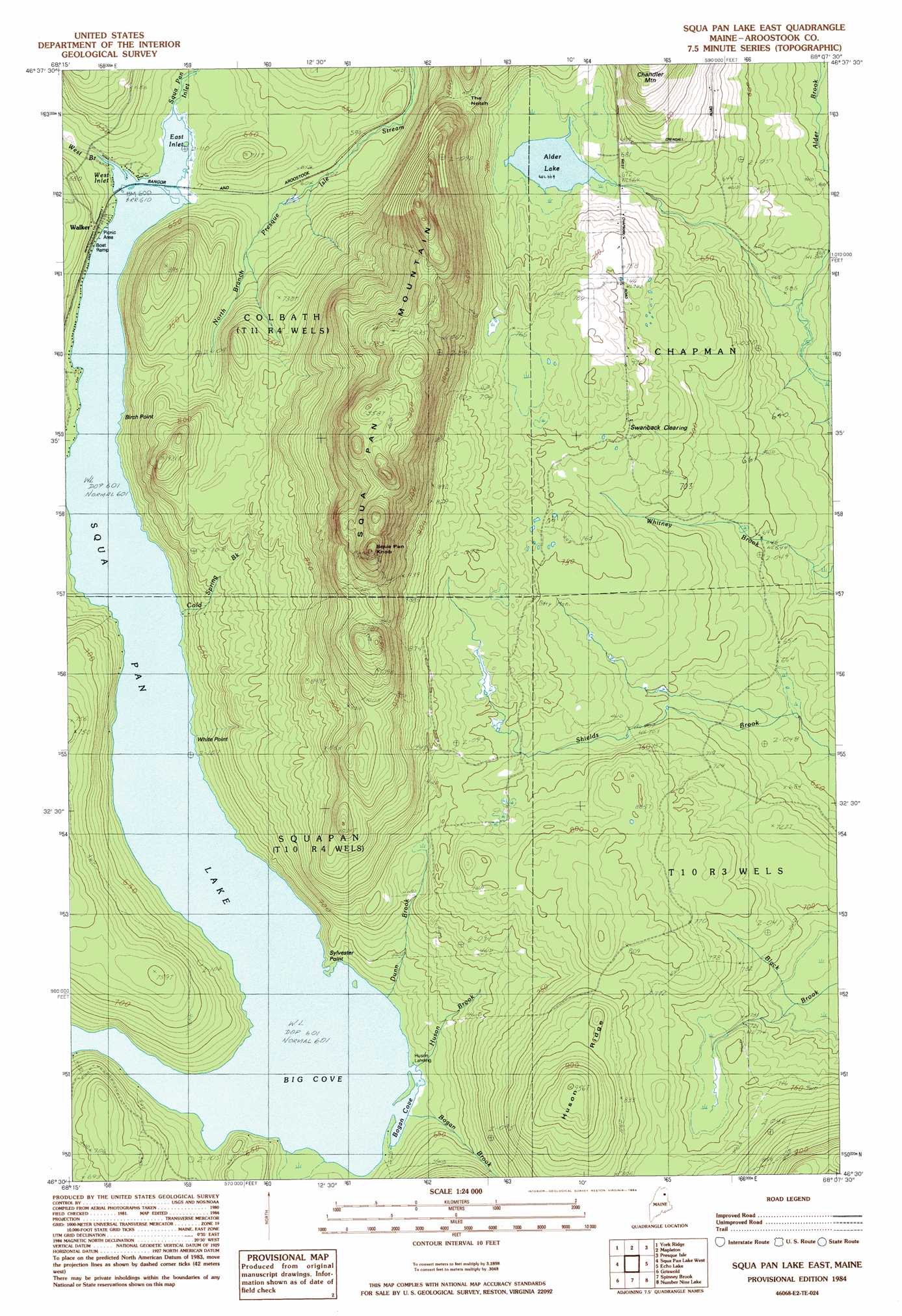
USGS Topo Quad 46068e2 - 1:24,000 scale
| Topo Map Name: | Squa Pan Lake East |
| USGS Topo Quad ID: | 46068e2 |
| Print Size: | ca. 21 1/4" wide x 27" high |
| Southeast Coordinates: | 46.5° N latitude / 68.125° W longitude |
| Map Center Coordinates: | 46.5625° N latitude / 68.1875° W longitude |
| U.S. State: | ME |
| Filename: | o46068e2.jpg |
| Download Map JPG Image: | Squa Pan Lake East topo map 1:24,000 scale |
| Map Type: | Topographic |
| Topo Series: | 7.5´ |
| Map Scale: | 1:24,000 |
| Source of Map Images: | United States Geological Survey (USGS) |
| Alternate Map Versions: |
Presque Isle SW ME 1975, updated 1981 Download PDF Buy paper map Squa Pan Lake East ME 1984, updated 1984 Download PDF Buy paper map Scopan Lake East ME 2011 Download PDF Buy paper map Scopan Lake East ME 2014 Download PDF Buy paper map |
1:24,000 Topo Quads surrounding Squa Pan Lake East
Portage Lake East |
Bull Brook |
Washburn |
Caribou |
Goodwin |
Ashland |
York Ridge |
Mapleton |
Presque Isle |
Easton |
Squa Pan |
Squa Pan Lake West |
Squa Pan Lake East |
Echo Lake |
Westfield |
Oxbow East |
Griswold |
Spinney Brook |
Number Nine Lake |
Packard Lake |
Umcolcus Lake |
Mcnally Ridge |
Saint Croix Lake |
North Brook Ridge |
Harvey |
> Back to 46068e1 at 1:100,000 scale
> Back to 46068a1 at 1:250,000 scale
> Back to U.S. Topo Maps home
Squa Pan Lake East topo map: Gazetteer
Squa Pan Lake East: Bays
Big Cove elevation 183m 600′Bogan Cove elevation 183m 600′
East Inlet elevation 183m 600′
West Inlet elevation 183m 600′
Squa Pan Lake East: Capes
Birch Point elevation 185m 606′Sylvester Point elevation 187m 613′
White Point elevation 183m 600′
Squa Pan Lake East: Flats
Swanback Clearing elevation 211m 692′Squa Pan Lake East: Gaps
The Notch elevation 252m 826′Squa Pan Lake East: Lakes
Alder Lake elevation 202m 662′Squa Pan Lake East: Populated Places
Huson Landing elevation 183m 600′Walker elevation 186m 610′
Squa Pan Lake East: Ridges
Huson Ridge elevation 257m 843′Squa Pan Lake East: Streams
Bogan Brook elevation 185m 606′Cold Spring Brook elevation 186m 610′
Dunn Brook elevation 184m 603′
Huson Brook elevation 186m 610′
Squapan Inlet elevation 184m 603′
West Branch Squa Pan Inlet elevation 186m 610′
Squa Pan Lake East: Summits
Squapan Knob elevation 432m 1417′Squapan Mountain elevation 433m 1420′
Squa Pan Lake East digital topo map on disk
Buy this Squa Pan Lake East topo map showing relief, roads, GPS coordinates and other geographical features, as a high-resolution digital map file on DVD:
Maine, New Hampshire, Rhode Island & Eastern Massachusetts
Buy digital topo maps: Maine, New Hampshire, Rhode Island & Eastern Massachusetts