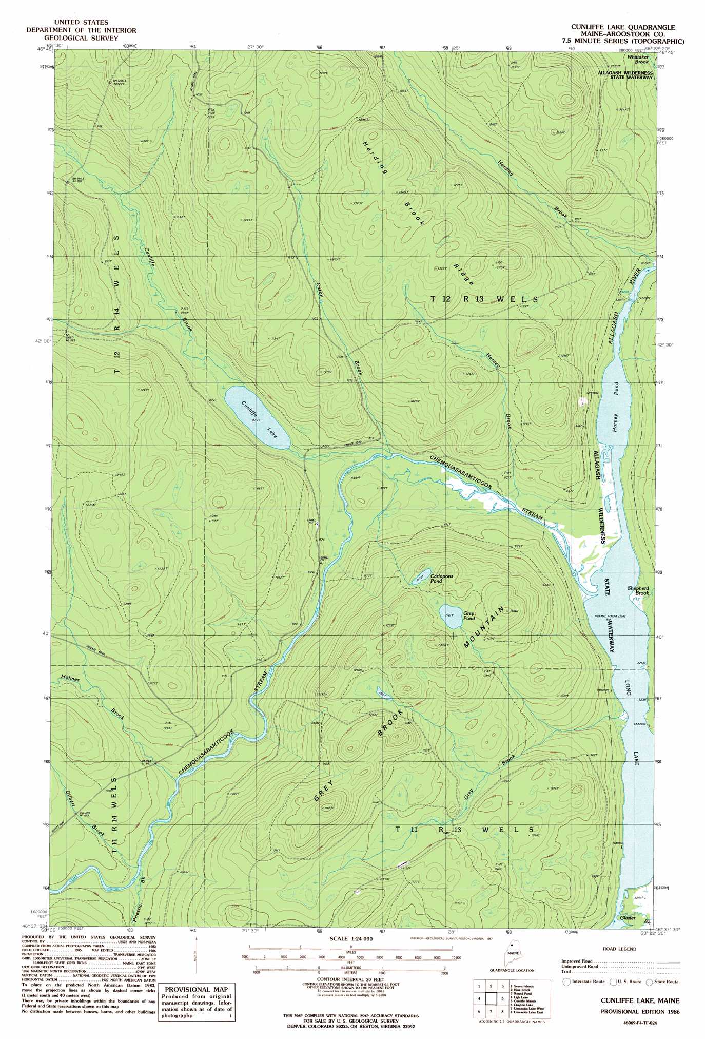
Cunliffe Lake Topo Map Maine
To zoom in, hover over the map of Cunliffe Lake
USGS Topo Quad 46069f4 - 1:24,000 scale
| Topo Map Name: | Cunliffe Lake |
| USGS Topo Quad ID: | 46069f4 |
| Print Size: | ca. 21 1/4" wide x 27" high |
| Southeast Coordinates: | 46.625° N latitude / 69.375° W longitude |
| Map Center Coordinates: | 46.6875° N latitude / 69.4375° W longitude |
| U.S. State: | ME |
| Filename: | o46069f4.jpg |
| Download Map JPG Image: | Cunliffe Lake topo map 1:24,000 scale |
| Map Type: | Topographic |
| Topo Series: | 7.5´ |
| Map Scale: | 1:24,000 |
| Source of Map Images: | United States Geological Survey (USGS) |
| Alternate Map Versions: |
Cunliffe Lake ME 1986, updated 1987 Download PDF Buy paper map Cunliffe Lake ME 2011 Download PDF Buy paper map Cunliffe Lake ME 2014 Download PDF Buy paper map |
1:24,000 Topo Quads surrounding Cunliffe Lake
Charles Pond |
Ninemile Deadwater |
Big Black Rapids |
Mckinnon Brook |
Allagash Falls |
Houlton Pond |
Seven Islands |
Blue Brook |
Round Pond |
Five Finger Brook |
Ninemile Bridge |
Ugh Lake |
Cunliffe Lake |
Cunliffe Islands |
First Musquacook Lake |
Fool Brook |
Clayton Lake |
Umaskis Lake West |
Umaskis Lake East |
Third Musquacook Lake |
Allagash Pond |
Upper Russell Pond |
Clarkson Pond |
Churchill Lake |
Spider Lake |
> Back to 46069e1 at 1:100,000 scale
> Back to 46068a1 at 1:250,000 scale
> Back to U.S. Topo Maps home
Cunliffe Lake topo map: Gazetteer
Cunliffe Lake: Dams
Long Lake Dam elevation 249m 816′Cunliffe Lake: Lakes
Cunliffe Lake elevation 255m 836′Grey Pond elevation 354m 1161′
Harvey Pond elevation 249m 816′
Cunliffe Lake: Reservoirs
Long Lake elevation 249m 816′Cunliffe Lake: Ridges
Harding Brook Ridge elevation 423m 1387′Cunliffe Lake: Streams
Caron Brook elevation 259m 849′Chemquasabamticook Stream elevation 249m 816′
Cunliffe Brook elevation 256m 839′
Gilbert Brook elevation 295m 967′
Glazier Brook elevation 249m 816′
Grey Brook elevation 249m 816′
Harvey Brook elevation 257m 843′
Holmes Brook elevation 285m 935′
Priestly Brook elevation 294m 964′
Shepherd Brook elevation 250m 820′
Cunliffe Lake: Summits
Grey Brook Mountain elevation 424m 1391′Cunliffe Lake digital topo map on disk
Buy this Cunliffe Lake topo map showing relief, roads, GPS coordinates and other geographical features, as a high-resolution digital map file on DVD:
Maine, New Hampshire, Rhode Island & Eastern Massachusetts
Buy digital topo maps: Maine, New Hampshire, Rhode Island & Eastern Massachusetts