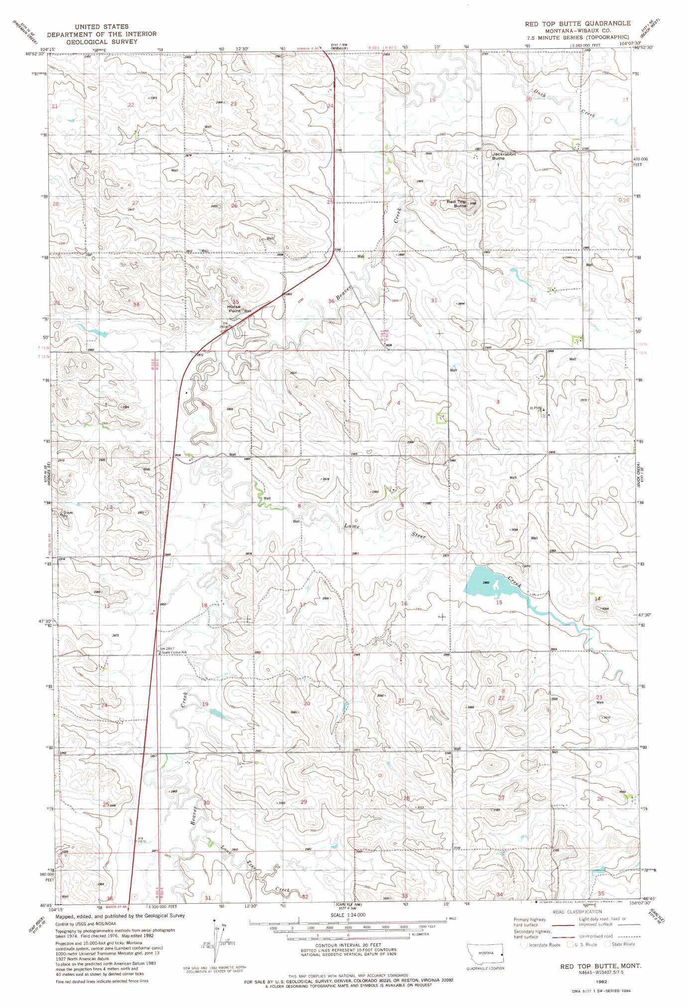
Red Top Butte Topo Map Montana
To zoom in, hover over the map of Red Top Butte
USGS Topo Quad 46104g2 - 1:24,000 scale
| Topo Map Name: | Red Top Butte |
| USGS Topo Quad ID: | 46104g2 |
| Print Size: | ca. 21 1/4" wide x 27" high |
| Southeast Coordinates: | 46.75° N latitude / 104.125° W longitude |
| Map Center Coordinates: | 46.8125° N latitude / 104.1875° W longitude |
| U.S. State: | MT |
| Filename: | o46104g2.jpg |
| Download Map JPG Image: | Red Top Butte topo map 1:24,000 scale |
| Map Type: | Topographic |
| Topo Series: | 7.5´ |
| Map Scale: | 1:24,000 |
| Source of Map Images: | United States Geological Survey (USGS) |
| Alternate Map Versions: |
Red Top Butte MT 1982, updated 1982 Download PDF Buy paper map Red Top Butte MT 2011 Download PDF Buy paper map Red Top Butte MT 2014 Download PDF Buy paper map |
1:24,000 Topo Quads surrounding Red Top Butte
Cluster Buttes Sw |
Cluster Buttes Se |
Odland Dam Sw |
Odland Dam |
Hootowl Creek Sw |
Hodges |
Freeman Creek |
Wibaux |
Beach West |
Beach East |
Hodges Sw |
Hodges Se |
Red Top Butte |
Duck Creek |
Thelan |
Rocking Chair Butte |
Cap Rock |
Carlyle Nw |
Carlyle |
Golva |
Lawrence Creek East |
Rush Hall Reservoir |
Shell Butte |
Ollie |
Williams Lake |
> Back to 46104e1 at 1:100,000 scale
> Back to 46104a1 at 1:250,000 scale
> Back to U.S. Topo Maps home
Red Top Butte topo map: Gazetteer
Red Top Butte: Dams
Lamesteer Reservoir Dam elevation 881m 2890′Red Top Butte: Parks
Lamesteer National Wildlife Refuge elevation 881m 2890′Red Top Butte: Populated Places
Saint Phillip elevation 874m 2867′Red Top Butte: Reservoirs
Lamesteer Reservoir elevation 881m 2890′Red Top Butte: Streams
Lamesteer Creek elevation 857m 2811′Lone Tree Creek elevation 871m 2857′
Red Top Butte: Summits
Horse Point elevation 862m 2828′Jackrabbit Butte elevation 898m 2946′
Podolski Butte elevation 935m 3067′
Red Top Butte elevation 933m 3061′
Red Top Butte: Wells
12N60E06CCC_01 Well elevation 863m 2831′12N60E11ABB_01 Well elevation 893m 2929′
12N60E22CCC_01 Well elevation 933m 3061′
12N60E28AADB01 Well elevation 929m 3047′
13N59E23CDDD01 Well elevation 884m 2900′
13N59E24BDD_01 Well elevation 851m 2791′
13N59E35AD__01 Well elevation 852m 2795′
13N60E30AAAA01 Well elevation 855m 2805′
Red Top Butte digital topo map on disk
Buy this Red Top Butte topo map showing relief, roads, GPS coordinates and other geographical features, as a high-resolution digital map file on DVD:
Eastern Montana & Western North Dakota
Buy digital topo maps: Eastern Montana & Western North Dakota