Gurneau Lake Topo Map Minnesota
To zoom in, hover over the map of Gurneau Lake
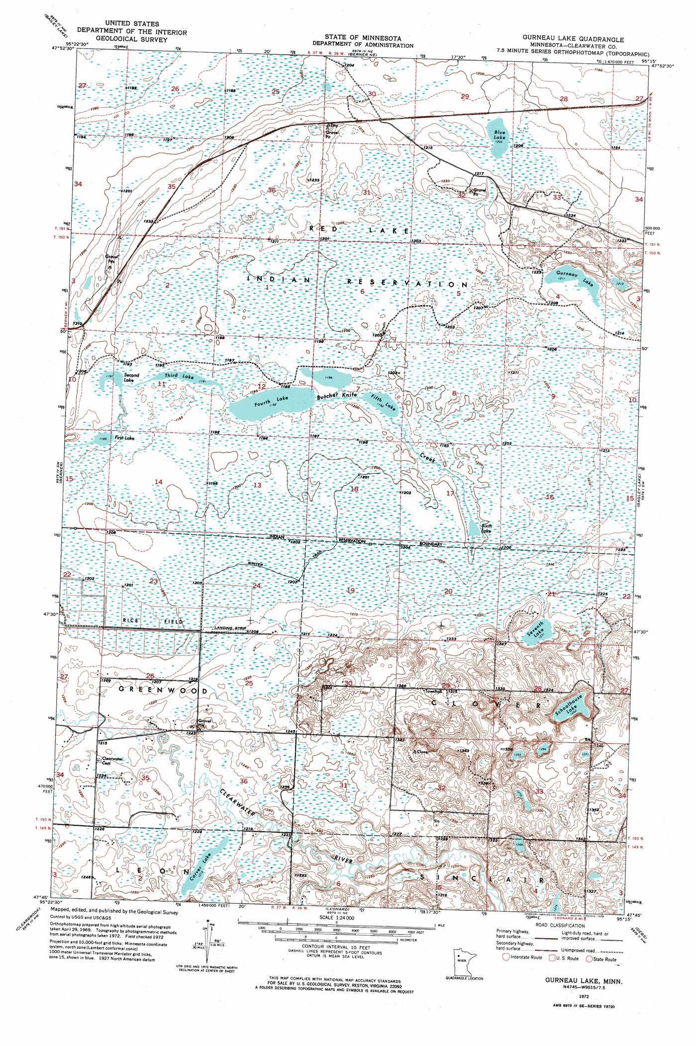
USGS Topo Quad 47095g3 - 1:24,000 scale
| Topo Map Name: | Gurneau Lake |
| USGS Topo Quad ID: | 47095g3 |
| Print Size: | ca. 21 1/4" wide x 27" high |
| Southeast Coordinates: | 47.75° N latitude / 95.25° W longitude |
| Map Center Coordinates: | 47.8125° N latitude / 95.3125° W longitude |
| U.S. State: | MN |
| Filename: | p47095g3.jpg |
| Download Map JPG Image: | Gurneau Lake topo map 1:24,000 scale |
| Map Type: | Orthophoto |
| Topo Series: | 7.5´ |
| Map Scale: | 1:24,000 |
| Source of Map Images: | United States Geological Survey (USGS) |
| Alternate Map Versions: |
Gurneau Lake MN 1972, updated 1976 Download PDF Buy paper map Gurneau Lake MN 2010 Download PDF Buy paper map Gurneau Lake MN 2013 Download PDF Buy paper map Gurneau Lake MN 2016 Download PDF Buy paper map |
1:24,000 Topo Quads surrounding Gurneau Lake
Good Lake |
Cahill Lake |
Gimiwan Lake |
Mosquito Creek |
Manomin Creek Se |
Gully Ne |
Bailey Lake |
Berner Ne |
||
Gully |
Berner |
Gurneau Lake |
Bagley Lake |
Red Lake |
Gonvick |
Clearbrook |
Leonard |
Debs |
Aure |
Fosston Se |
Bagley |
Shevlin |
Solway |
Wilton |
> Back to 47095e1 at 1:100,000 scale
> Back to 47094a1 at 1:250,000 scale
> Back to U.S. Topo Maps home
Gurneau Lake topo map: Gazetteer
Gurneau Lake: Airports
Bardwell Airstrip elevation 374m 1227′Gurneau Lake: Lakes
Blue Lake elevation 368m 1207′Carver Lake elevation 371m 1217′
Fifth Lake elevation 364m 1194′
First Lake elevation 363m 1190′
Fourth Lake elevation 364m 1194′
Gurneau Lake elevation 369m 1210′
Schoolhouse Lake elevation 385m 1263′
Second Lake elevation 363m 1190′
Seventh Lake elevation 376m 1233′
Sixth Lake elevation 364m 1194′
Third Lake elevation 363m 1190′
Gurneau Lake: Post Offices
Churnes Post Office (historical) elevation 369m 1210′Gurneau Lake digital topo map on disk
Buy this Gurneau Lake topo map showing relief, roads, GPS coordinates and other geographical features, as a high-resolution digital map file on DVD: