Antelope Butte Topo Map Montana
To zoom in, hover over the map of Antelope Butte
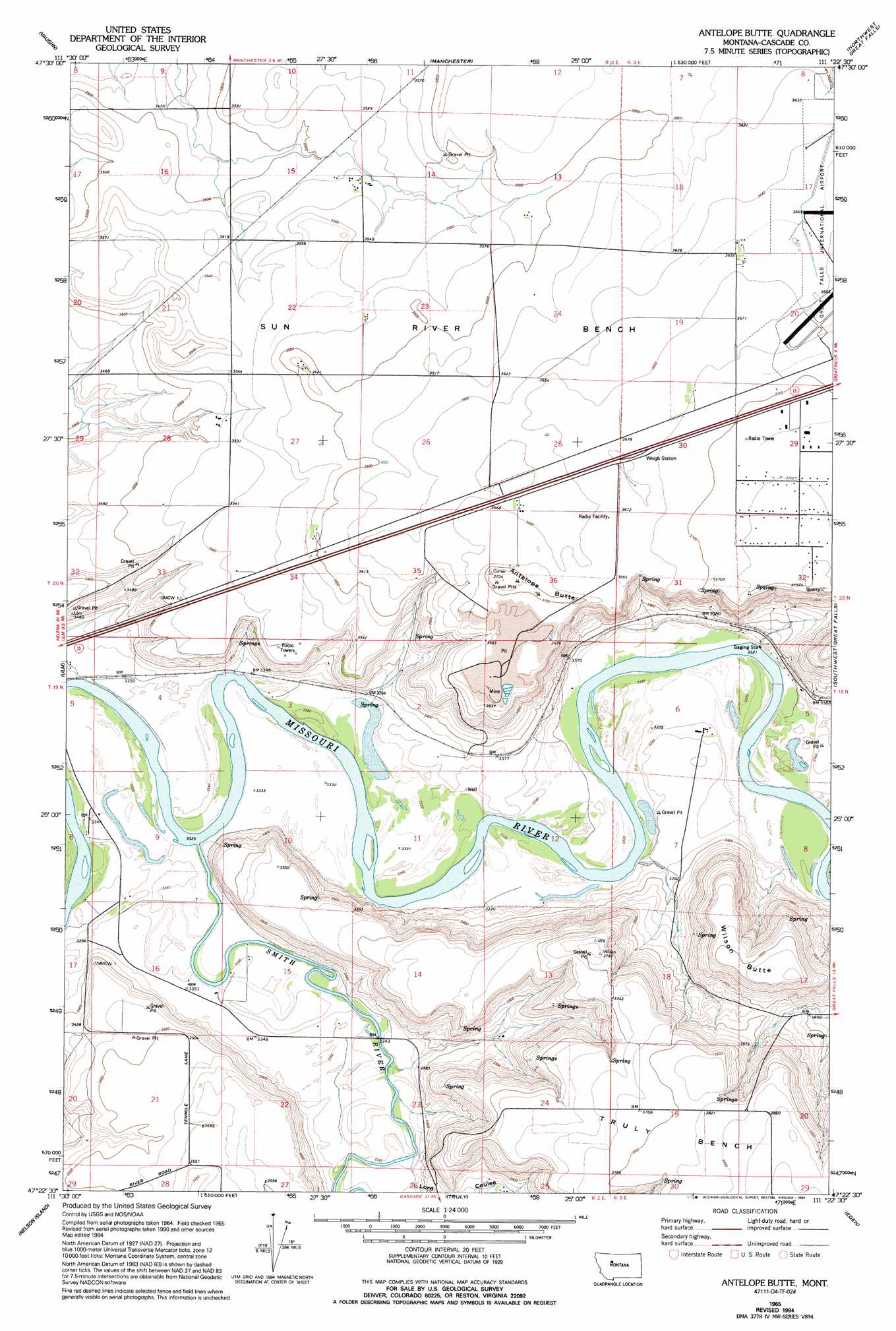
USGS Topo Quad 47111d4 - 1:24,000 scale
| Topo Map Name: | Antelope Butte |
| USGS Topo Quad ID: | 47111d4 |
| Print Size: | ca. 21 1/4" wide x 27" high |
| Southeast Coordinates: | 47.375° N latitude / 111.375° W longitude |
| Map Center Coordinates: | 47.4375° N latitude / 111.4375° W longitude |
| U.S. State: | MT |
| Filename: | o47111d4.jpg |
| Download Map JPG Image: | Antelope Butte topo map 1:24,000 scale |
| Map Type: | Topographic |
| Topo Series: | 7.5´ |
| Map Scale: | 1:24,000 |
| Source of Map Images: | United States Geological Survey (USGS) |
| Alternate Map Versions: |
Antelope Butte MT 1965, updated 1967 Download PDF Buy paper map Antelope Butte MT 1965, updated 1977 Download PDF Buy paper map Antelope Butte MT 1965, updated 1994 Download PDF Buy paper map Antelope Butte MT 2011 Download PDF Buy paper map Antelope Butte MT 2014 Download PDF Buy paper map |
1:24,000 Topo Quads surrounding Antelope Butte
Power |
Vaughn Ne |
Benton Lake West |
Benton Lake East |
Flick Lake |
Sun River |
Vaughn |
Manchester |
Northwest Great Falls |
Northeast Great Falls |
Fair Haven Colony |
Ulm |
Antelope Butte |
Southwest Great Falls |
Southeast Great Falls |
Cascade |
Nelson Island |
Truly |
Eden |
Stockett |
Rocky Reef |
Schrammeck Lake |
Spanish Coulee School |
Boston Coulee School |
Calvert |
> Back to 47111a1 at 1:100,000 scale
> Back to 47110a1 at 1:250,000 scale
> Back to U.S. Topo Maps home
Antelope Butte topo map: Gazetteer
Antelope Butte: Airports
Bair Airport elevation 1019m 3343′Buchanan Ranch Airport elevation 1017m 3336′
Smith Farms Airport elevation 1019m 3343′
Antelope Butte: Benches
Sun River Bench elevation 1100m 3608′Antelope Butte: Parks
Sun River Historical Marker (historical) elevation 1123m 3684′Antelope Butte: Streams
Smith River elevation 1015m 3330′Antelope Butte: Summits
Antelope Butte elevation 1135m 3723′Wilson Butte elevation 1173m 3848′
Antelope Butte: Valleys
Lord Coulee elevation 1019m 3343′Antelope Butte: Wells
19N02E01BCBC01 Well elevation 1118m 3667′19N02E08DDDD01 Well elevation 1019m 3343′
19N02E21D___01 Well elevation 1078m 3536′
19N02E23C___01 Well elevation 1018m 3339′
19N03E05BABA01 Well elevation 1048m 3438′
20N02E13____01 Well elevation 1095m 3592′
20N02E15____01 Well elevation 1072m 3517′
20N02E15A___01 Well elevation 1070m 3510′
20N02E15D___01 Well elevation 1082m 3549′
20N02E21____01 Well elevation 1088m 3569′
20N02E22____01 Well elevation 1089m 3572′
20N02E22C___01 Well elevation 1088m 3569′
20N02E22C___02 Well elevation 1088m 3569′
20N02E22C___03 Well elevation 1088m 3569′
20N02E22C___04 Well elevation 1088m 3569′
20N02E22D___01 Well elevation 1094m 3589′
20N02E23A___01 Well elevation 1093m 3585′
20N02E23C___01 Well elevation 1097m 3599′
20N02E24B___01 Well elevation 1100m 3608′
20N02E25C___01 Well elevation 1109m 3638′
20N02E28____01 Well elevation 1067m 3500′
20N02E28____02 Well elevation 1067m 3500′
20N02E28A___01 Well elevation 1069m 3507′
20N02E33B___01 Well elevation 1068m 3503′
20N02E33B___02 Well elevation 1068m 3503′
20N02E34A___01 Well elevation 1099m 3605′
20N02E35D___01 Well elevation 1118m 3667′
20N03E08DCBB01 Well elevation 1105m 3625′
20N03E17C___01 Well elevation 1113m 3651′
20N03E29ACBA01 Well elevation 1132m 3713′
20N03E29ADCC01 Well elevation 1132m 3713′
20N03E30A___01 Well elevation 1126m 3694′
20N03E32DBAB01 Well elevation 1142m 3746′
20N04E16CCBA02 Well elevation 1107m 3631′
Antelope Butte digital topo map on disk
Buy this Antelope Butte topo map showing relief, roads, GPS coordinates and other geographical features, as a high-resolution digital map file on DVD: