Evaro Topo Map Montana
To zoom in, hover over the map of Evaro
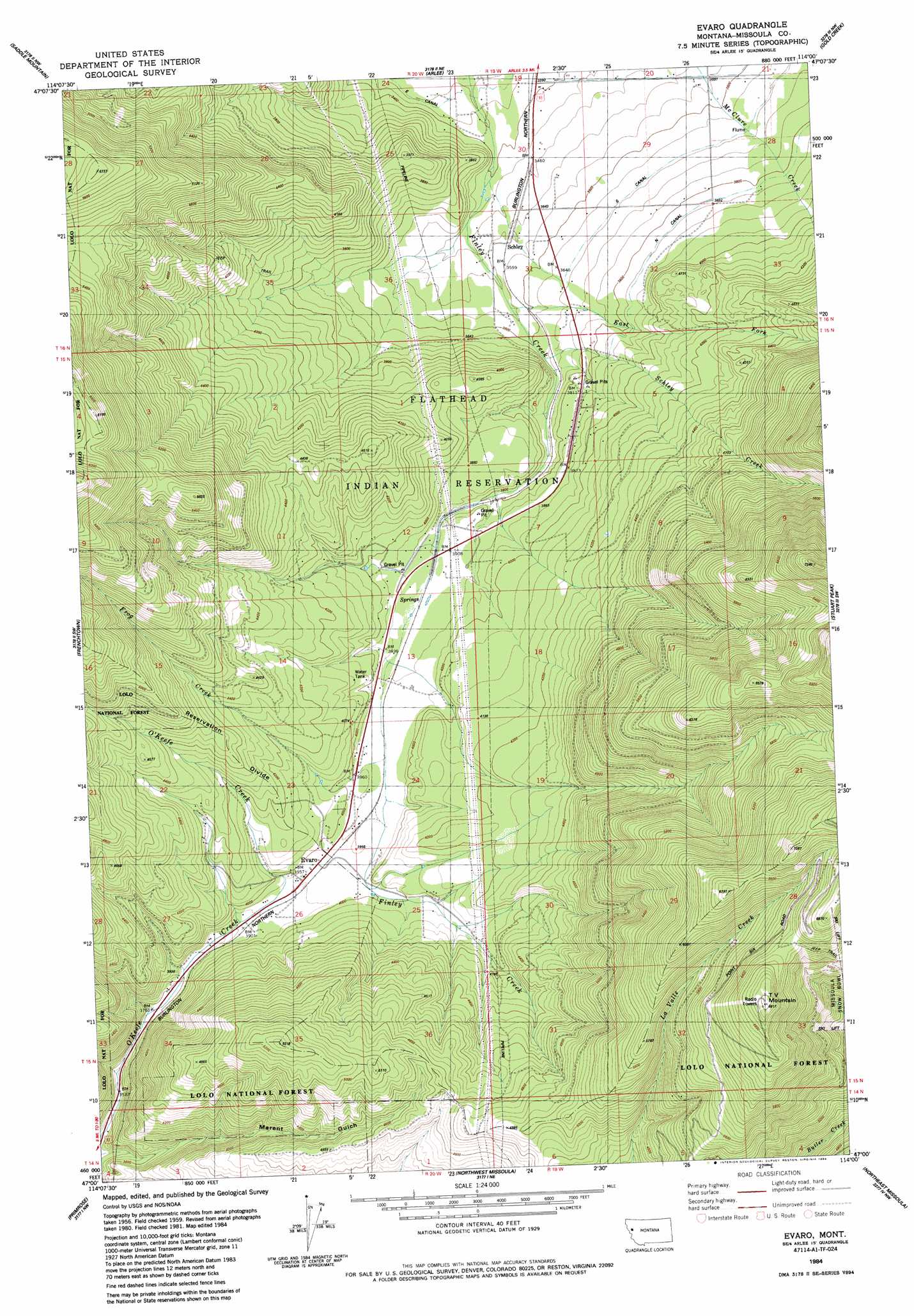
USGS Topo Quad 47114a1 - 1:24,000 scale
| Topo Map Name: | Evaro |
| USGS Topo Quad ID: | 47114a1 |
| Print Size: | ca. 21 1/4" wide x 27" high |
| Southeast Coordinates: | 47° N latitude / 114° W longitude |
| Map Center Coordinates: | 47.0625° N latitude / 114.0625° W longitude |
| U.S. State: | MT |
| Filename: | o47114a1.jpg |
| Download Map JPG Image: | Evaro topo map 1:24,000 scale |
| Map Type: | Topographic |
| Topo Series: | 7.5´ |
| Map Scale: | 1:24,000 |
| Source of Map Images: | United States Geological Survey (USGS) |
| Alternate Map Versions: |
Evaro MT 1984, updated 1984 Download PDF Buy paper map Evaro MT 1999, updated 2003 Download PDF Buy paper map Evaro MT 2011 Download PDF Buy paper map Evaro MT 2014 Download PDF Buy paper map |
| FStopo: | US Forest Service topo Evaro is available: Download FStopo PDF Download FStopo TIF |
1:24,000 Topo Quads surrounding Evaro
Dixon |
Ravalli |
Saint Ignatius |
Saint Marys Lake |
Gray Wolf Lake |
Hewolf Mountain |
Saddle Mountain |
Arlee |
Gold Creek |
Belmore Sloughs |
Huson |
Frenchtown |
Evaro |
Stuart Peak |
Wapiti Lake |
Diamond Point |
Primrose |
Northwest Missoula |
Northeast Missoula |
Blue Point |
Camp Creek |
Blue Mountain |
Southwest Missoula |
Southeast Missoula |
Bonner |
> Back to 47114a1 at 1:100,000 scale
> Back to 47114a1 at 1:250,000 scale
> Back to U.S. Topo Maps home
Evaro topo map: Gazetteer
Evaro: Bridges
Marent Trestle elevation 1048m 3438′Evaro: Canals
N Canal elevation 1174m 3851′Evaro: Gaps
Coriacan Defile elevation 1186m 3891′Evaro: Parks
Snow Park Ski Area elevation 1697m 5567′Evaro: Populated Places
Evaro elevation 1207m 3959′Schley elevation 1078m 3536′
Evaro: Post Offices
Evaro Post Office (historical) elevation 1207m 3959′Evaro: Streams
East Fork Finley Creek elevation 1084m 3556′Frog Creek elevation 1200m 3937′
Schley Creek elevation 1109m 3638′
Evaro: Summits
TV Mountain elevation 2079m 6820′Evaro: Valleys
Marent Gulch elevation 1048m 3438′Evaro: Wells
14N20W03AA__01 Well elevation 1264m 4146′15N19W05BBCC01 Well elevation 1162m 3812′
15N19W05BCCC01 Well elevation 1181m 3874′
15N19W07BCCC01 Well elevation 1184m 3884′
15N20W12CAAC01 Well elevation 1217m 3992′
15N20W12CAD_01 Well elevation 1206m 3956′
15N20W13BABB01 Well elevation 1209m 3966′
15N20W13BCCC01 Well elevation 1196m 3923′
15N20W13CADA01 Well elevation 1196m 3923′
15N20W13CADA02 Well elevation 1196m 3923′
15N20W13CADA03 Well elevation 1196m 3923′
15N20W13DCAA01 Well elevation 1184m 3884′
15N20W23DCAA01 Well elevation 1233m 4045′
15N20W24BCCB01 Well elevation 1257m 4124′
15N20W26ABC_01 Well elevation 1208m 3963′
16N19W30BCCD01 Well elevation 1049m 3441′
16N19W30CDBC01 Well elevation 1046m 3431′
16N19W30DBA_01 Well elevation 1061m 3480′
16N19W31BBBB01 Well elevation 1049m 3441′
16N19W31CBA_01 Well elevation 1077m 3533′
16N19W31DABB01 Well elevation 1118m 3667′
16N19W31DDAB01 Well elevation 1135m 3723′
Evaro digital topo map on disk
Buy this Evaro topo map showing relief, roads, GPS coordinates and other geographical features, as a high-resolution digital map file on DVD: