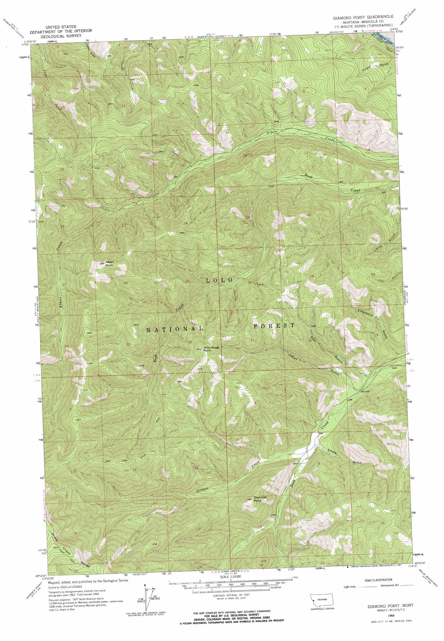
Diamond Point Topo Map Montana
To zoom in, hover over the map of Diamond Point
USGS Topo Quad 46114h3 - 1:24,000 scale
| Topo Map Name: | Diamond Point |
| USGS Topo Quad ID: | 46114h3 |
| Print Size: | ca. 21 1/4" wide x 27" high |
| Southeast Coordinates: | 46.875° N latitude / 114.25° W longitude |
| Map Center Coordinates: | 46.9375° N latitude / 114.3125° W longitude |
| U.S. State: | MT |
| Filename: | o46114h3.jpg |
| Download Map JPG Image: | Diamond Point topo map 1:24,000 scale |
| Map Type: | Topographic |
| Topo Series: | 7.5´ |
| Map Scale: | 1:24,000 |
| Source of Map Images: | United States Geological Survey (USGS) |
| Alternate Map Versions: |
Diamond Point MT 1964, updated 1967 Download PDF Buy paper map Diamond Point MT 1964, updated 1967 Download PDF Buy paper map Diamond Point MT 1999, updated 2003 Download PDF Buy paper map Diamond Point MT 2011 Download PDF Buy paper map Diamond Point MT 2014 Download PDF Buy paper map |
| FStopo: | US Forest Service topo Diamond Point is available: Download FStopo PDF Download FStopo TIF |
1:24,000 Topo Quads surrounding Diamond Point
Stark North |
Mccormick Peak |
Hewolf Mountain |
Saddle Mountain |
Arlee |
Stark South |
Alberton |
Huson |
Frenchtown |
Evaro |
Deer Peak |
Petty Mountain |
Diamond Point |
Primrose |
Northwest Missoula |
Lupine Creek |
Garden Point |
Camp Creek |
Blue Mountain |
Southwest Missoula |
Lolo Hot Springs |
West Fork Butte |
Dick Creek |
Carlton Lake |
Florence |
> Back to 46114e1 at 1:100,000 scale
> Back to 46114a1 at 1:250,000 scale
> Back to U.S. Topo Maps home
Diamond Point topo map: Gazetteer
Diamond Point: Mines
Wheeler Barite Mine elevation 1650m 5413′Diamond Point: Streams
Gilman Creek elevation 1092m 3582′Diamond Point: Summits
Albert Point elevation 1812m 5944′Diamond Point elevation 1517m 4977′
Wild Horse Point elevation 1768m 5800′
Diamond Point: Valleys
Bear Gulch elevation 1046m 3431′Elderberry Gulch elevation 1032m 3385′
Emma Gulch elevation 1096m 3595′
Futter Gulch elevation 922m 3024′
Indian Gulch elevation 1059m 3474′
Diamond Point digital topo map on disk
Buy this Diamond Point topo map showing relief, roads, GPS coordinates and other geographical features, as a high-resolution digital map file on DVD: