Dupuyer West Topo Map Montana
To zoom in, hover over the map of Dupuyer West
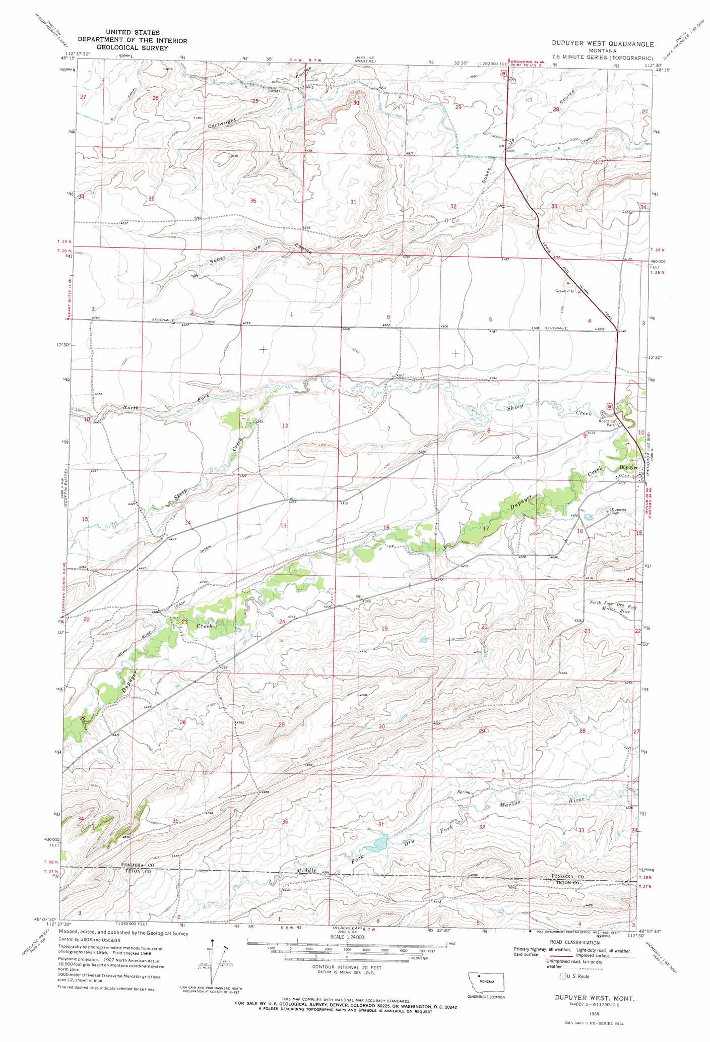
USGS Topo Quad 48112b5 - 1:24,000 scale
| Topo Map Name: | Dupuyer West |
| USGS Topo Quad ID: | 48112b5 |
| Print Size: | ca. 21 1/4" wide x 27" high |
| Southeast Coordinates: | 48.125° N latitude / 112.5° W longitude |
| Map Center Coordinates: | 48.1875° N latitude / 112.5625° W longitude |
| U.S. State: | MT |
| Filename: | o48112b5.jpg |
| Download Map JPG Image: | Dupuyer West topo map 1:24,000 scale |
| Map Type: | Topographic |
| Topo Series: | 7.5´ |
| Map Scale: | 1:24,000 |
| Source of Map Images: | United States Geological Survey (USGS) |
| Alternate Map Versions: |
Dupuyer West MT 1968, updated 1972 Download PDF Buy paper map Dupuyer West MT 2011 Download PDF Buy paper map Dupuyer West MT 2014 Download PDF Buy paper map |
1:24,000 Topo Quads surrounding Dupuyer West
White Man Coulee |
Piegan |
Rocky Ridge |
Flag Butte |
Rock City |
Heart Butte |
Four Horns Lake |
Robere |
Kuka Crossing |
Valier West |
Fish Lake |
Scoffin Butte |
Dupuyer West |
Dupuyer East |
Lone Man Coulee West |
Walling Reef |
Volcano Reef |
Blackleaf |
Soap Creek |
Pendroy |
Mount Wright |
Cave Mountain |
Twin Lakes |
Bynum Reservoir |
Bynum |
> Back to 48112a1 at 1:100,000 scale
> Back to 48112a1 at 1:250,000 scale
> Back to U.S. Topo Maps home
Dupuyer West topo map: Gazetteer
Dupuyer West: Canals
B Canal elevation 1224m 4015′Dean Burd Leach Ditch elevation 1337m 4386′
Dupuyer West: Dams
Scott Ranch Dam elevation 1357m 4452′Dupuyer West: Parks
Chief Mountain and Old North Trail Historical Marker elevation 1253m 4110′Dupuyer Historical Marker elevation 1257m 4124′
Dupuyer West: Streams
North Fork Sheep Creek elevation 1285m 4215′Dupuyer West: Valleys
Hagers Coulee elevation 1342m 4402′Jones Coulee elevation 1355m 4445′
Dupuyer West digital topo map on disk
Buy this Dupuyer West topo map showing relief, roads, GPS coordinates and other geographical features, as a high-resolution digital map file on DVD: