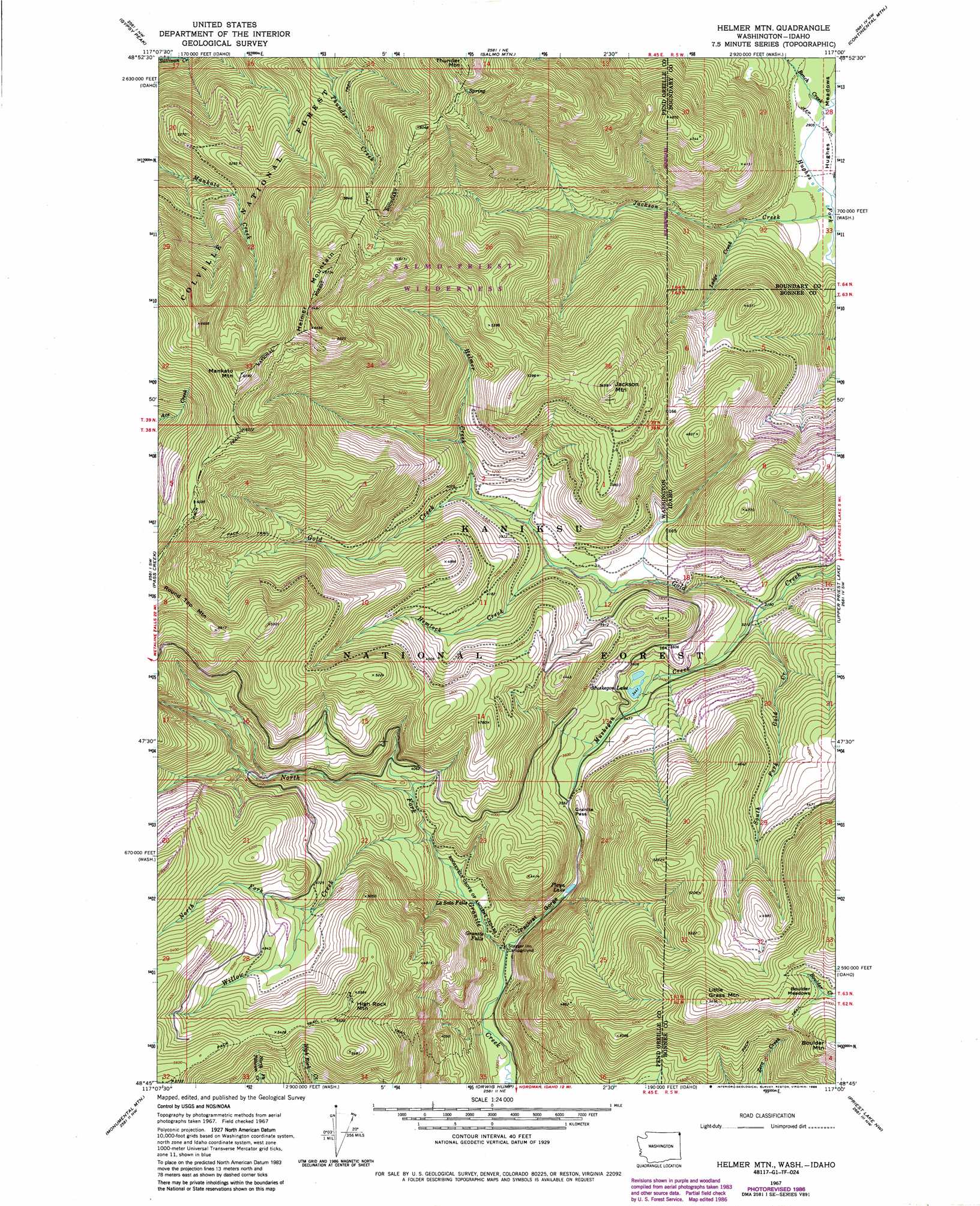
Helmer Mountain Topo Map Washington
To zoom in, hover over the map of Helmer Mountain
USGS Topo Quad 48117g1 - 1:24,000 scale
| Topo Map Name: | Helmer Mountain |
| USGS Topo Quad ID: | 48117g1 |
| Print Size: | ca. 21 1/4" wide x 27" high |
| Southeast Coordinates: | 48.75° N latitude / 117° W longitude |
| Map Center Coordinates: | 48.8125° N latitude / 117.0625° W longitude |
| U.S. States: | WA, ID |
| Filename: | o48117g1.jpg |
| Download Map JPG Image: | Helmer Mountain topo map 1:24,000 scale |
| Map Type: | Topographic |
| Topo Series: | 7.5´ |
| Map Scale: | 1:24,000 |
| Source of Map Images: | United States Geological Survey (USGS) |
| Alternate Map Versions: |
Helmer Mtn WA 1967, updated 1971 Download PDF Buy paper map Helmer Mtn WA 1967, updated 1982 Download PDF Buy paper map Helmer Mtn WA 1967, updated 1986 Download PDF Buy paper map Helmer Mountain WA 1996, updated 1999 Download PDF Buy paper map Helmer Mountain WA 2011 Download PDF Buy paper map Helmer Mountain WA 2014 Download PDF Buy paper map |
| FStopo: | US Forest Service topo Helmer Mountain is available: Download FStopo PDF Download FStopo TIF |
1:24,000 Topo Quads surrounding Helmer Mountain
Boundary Dam |
Gypsy Peak |
Salmo Mountain |
Continental Mountain |
Grass Mountain |
Metaline Falls |
Pass Creek |
Helmer Mountain |
Upper Priest Lake |
Caribou Creek |
Scotchman Lake |
Monumental Mountain |
Orwig Hump |
Priest Lake Nw |
Priest Lake Ne |
Ruby |
North Baldy |
Gleason Mountain |
Priest Lake Sw |
Priest Lake Se |
> Back to 48117e1 at 1:100,000 scale
> Back to 48116a1 at 1:250,000 scale
> Back to U.S. Topo Maps home
Helmer Mountain topo map: Gazetteer
Helmer Mountain: Falls
Granite Falls elevation 1066m 3497′LaSota Falls elevation 1074m 3523′
Helmer Mountain: Flats
Boulder Meadows elevation 1519m 4983′Hughes Meadows elevation 891m 2923′
Helmer Mountain: Gaps
Gold and Granite Pass elevation 1404m 4606′Granite Pass elevation 1095m 3592′
Helmer Mountain: Lakes
Muskegon Lake elevation 1058m 3471′Playa Lake elevation 1071m 3513′
Helmer Mountain: Streams
Bench Creek elevation 888m 2913′Bench Creek elevation 923m 3028′
Gold Creek elevation 928m 3044′
Helmer Creek elevation 1203m 3946′
Hemlock Creek elevation 1141m 3743′
Jackson Creek elevation 883m 2896′
Jackson Creek elevation 883m 2896′
Ledge Creek elevation 938m 3077′
Muskegon Creek elevation 968m 3175′
Muskegon Creek elevation 969m 3179′
North Fork Willow Creek elevation 1417m 4648′
South Fork Gold Creek elevation 962m 3156′
Willow Creek elevation 1146m 3759′
Helmer Mountain: Summits
Helmer Mountain elevation 2053m 6735′High Rock Mountain elevation 1698m 5570′
Jackson Mountain elevation 1675m 5495′
Little Grass Mountain elevation 1735m 5692′
Mankato Mountain elevation 2005m 6578′
Helmer Mountain: Valleys
Packrat Gorge elevation 1018m 3339′Helmer Mountain: Woods
Roosevelt Grove of Ancient Cedars elevation 1083m 3553′Helmer Mountain digital topo map on disk
Buy this Helmer Mountain topo map showing relief, roads, GPS coordinates and other geographical features, as a high-resolution digital map file on DVD: