Tatoosh Buttes Topo Map Washington
To zoom in, hover over the map of Tatoosh Buttes
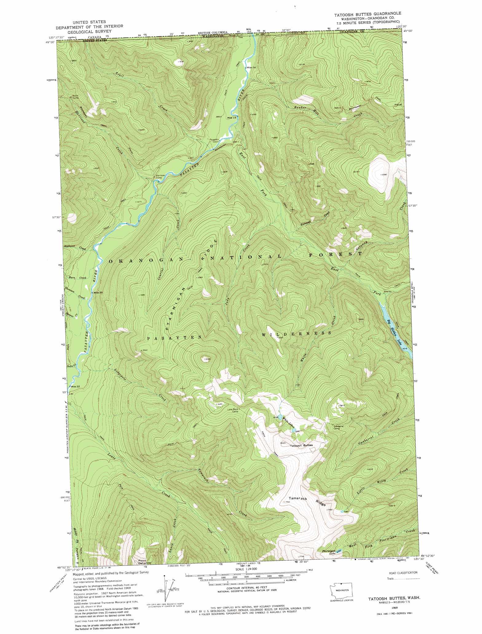
USGS Topo Quad 48120h5 - 1:24,000 scale
| Topo Map Name: | Tatoosh Buttes |
| USGS Topo Quad ID: | 48120h5 |
| Print Size: | ca. 21 1/4" wide x 27" high |
| Southeast Coordinates: | 48.875° N latitude / 120.5° W longitude |
| Map Center Coordinates: | 48.9375° N latitude / 120.5625° W longitude |
| U.S. State: | WA |
| Filename: | o48120h5.jpg |
| Download Map JPG Image: | Tatoosh Buttes topo map 1:24,000 scale |
| Map Type: | Topographic |
| Topo Series: | 7.5´ |
| Map Scale: | 1:24,000 |
| Source of Map Images: | United States Geological Survey (USGS) |
| Alternate Map Versions: |
Tatoosh Buttes WA 1969, updated 1973 Download PDF Buy paper map Tatoosh Buttes WA 2002, updated 2006 Download PDF Buy paper map Tatoosh Buttes WA 2011 Download PDF Buy paper map Tatoosh Buttes WA 2014 Download PDF Buy paper map |
| FStopo: | US Forest Service topo Tatoosh Buttes is available: Download FStopo PDF Download FStopo TIF |
1:24,000 Topo Quads surrounding Tatoosh Buttes
Castle Peak |
Frosty Creek |
Tatoosh Buttes |
Ashnola Mountain |
Ashnola Pass |
Shull Mountain |
Pasayten Peak |
Mount Lago |
Lost Peak |
Billy Goat Mountain |
Azurite Peak |
Slate Peak |
Robinson Mountain |
Mcleod Mountain |
Sweetgrass Butte |
> Back to 48120e1 at 1:100,000 scale
> Back to 48120a1 at 1:250,000 scale
> Back to U.S. Topo Maps home
Tatoosh Buttes topo map: Gazetteer
Tatoosh Buttes: Flats
Sunset Meadow elevation 1371m 4498′Tatoosh Buttes: Lakes
Big Hidden Lake elevation 1317m 4320′Ptarmigan Lake elevation 2047m 6715′
White Lake elevation 1935m 6348′
White Lakes elevation 2039m 6689′
Tatoosh Buttes: Ridges
Ptarmigan Ridge elevation 1698m 5570′Tamarack Ridge elevation 2306m 7565′
Tatoosh Buttes: Streams
Bunker Hill Creek elevation 1180m 3871′Burn Creek elevation 1236m 4055′
Central Creek elevation 1208m 3963′
East Fork Pasayten River elevation 1184m 3884′
Farewell Creek elevation 1247m 4091′
Getaway Creek elevation 1302m 4271′
Harrison Creek elevation 1207m 3959′
Holdover Creek elevation 1237m 4058′
Honess Creek elevation 1253m 4110′
Judy Creek elevation 1243m 4078′
Lodgepole Creek elevation 1267m 4156′
Lunch Creek elevation 1456m 4776′
Soda Creek elevation 1267m 4156′
Tamarack Creek elevation 1436m 4711′
Thomson Creek elevation 1244m 4081′
Trail Creek elevation 1191m 3907′
White Creek elevation 1298m 4258′
Tatoosh Buttes: Summits
Point Defiance elevation 2233m 7326′Tatoosh Buttes elevation 2115m 6938′
Tatoosh Buttes digital topo map on disk
Buy this Tatoosh Buttes topo map showing relief, roads, GPS coordinates and other geographical features, as a high-resolution digital map file on DVD: