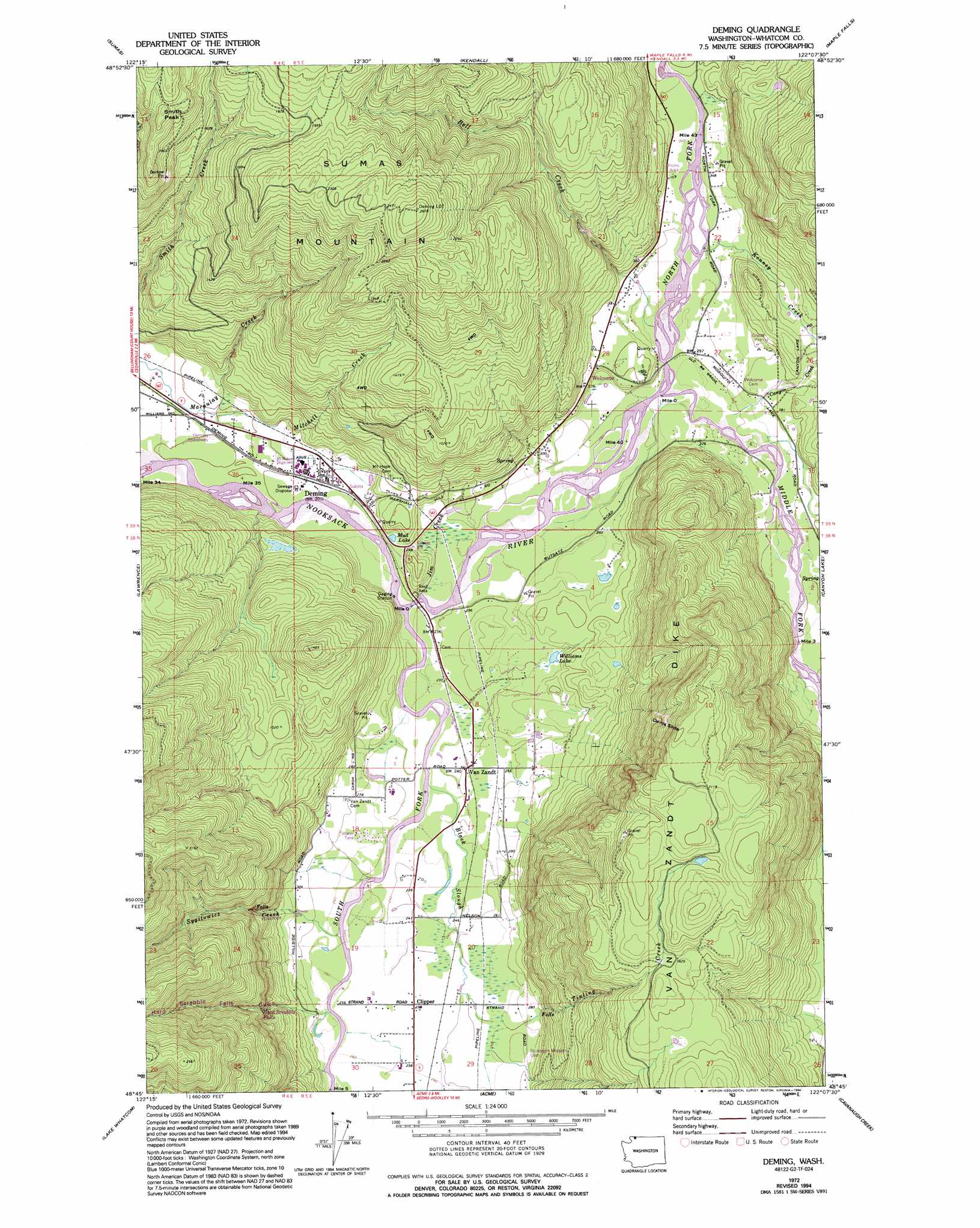
Deming Topo Map Washington
To zoom in, hover over the map of Deming
USGS Topo Quad 48122g2 - 1:24,000 scale
| Topo Map Name: | Deming |
| USGS Topo Quad ID: | 48122g2 |
| Print Size: | ca. 21 1/4" wide x 27" high |
| Southeast Coordinates: | 48.75° N latitude / 122.125° W longitude |
| Map Center Coordinates: | 48.8125° N latitude / 122.1875° W longitude |
| U.S. State: | WA |
| Filename: | o48122g2.jpg |
| Download Map JPG Image: | Deming topo map 1:24,000 scale |
| Map Type: | Topographic |
| Topo Series: | 7.5´ |
| Map Scale: | 1:24,000 |
| Source of Map Images: | United States Geological Survey (USGS) |
| Alternate Map Versions: |
Deming WA 1972, updated 1977 Download PDF Buy paper map Deming WA 1972, updated 1994 Download PDF Buy paper map Deming WA 2011 Download PDF Buy paper map Deming WA 2014 Download PDF Buy paper map |
1:24,000 Topo Quads surrounding Deming
Lynden |
Sumas |
Kendall |
Maple Falls |
Glacier |
Bellingham North |
Lawrence |
Deming |
Canyon Lake |
Groat Mountain |
Bellingham South |
Lake Whatcom |
Acme |
Cavanaugh Creek |
Twin Sisters Mountain |
Bow |
Alger |
Sedro-Woolley North |
Lyman |
Hamilton |
> Back to 48122e1 at 1:100,000 scale
> Back to 48122a1 at 1:250,000 scale
> Back to U.S. Topo Maps home
Deming topo map: Gazetteer
Deming: Falls
Hard Scrabble Falls elevation 256m 839′Deming: Lakes
Mud Lake elevation 78m 255′Williams Lake elevation 97m 318′
Deming: Pillars
Smith Peak elevation 693m 2273′Deming: Populated Places
Clipper elevation 78m 255′Deming elevation 67m 219′
Kulshan elevation 112m 367′
Van Zandt elevation 75m 246′
Welcome elevation 118m 387′
Deming: Ridges
Van Zandt Dike elevation 674m 2211′Deming: Slopes
Devils Slide elevation 539m 1768′Deming: Streams
Bell Creek elevation 91m 298′Black Slough elevation 71m 232′
Canyon Creek elevation 97m 318′
Hard Scrabble Falls Creek elevation 80m 262′
Jim Creek elevation 67m 219′
Kenney Creek elevation 98m 321′
Middle Fork Nooksack River elevation 88m 288′
Mitchell Creek elevation 60m 196′
North Fork Nooksack River elevation 88m 288′
Porter Creek elevation 135m 442′
South Fork Nooksack River elevation 67m 219′
Sygitowicz Creek elevation 74m 242′
Tinling Creek elevation 77m 252′
Deming: Valleys
Hard Scrabble Falls Gulch elevation 105m 344′Deming digital topo map on disk
Buy this Deming topo map showing relief, roads, GPS coordinates and other geographical features, as a high-resolution digital map file on DVD: