Bolivar Topo Map Missouri
To zoom in, hover over the map of Bolivar
USGS Topo Map 37093e1 - 1:100,000 scale
| Topo Map Name: | Bolivar |
| USGS Topo Quad ID: | 37093e1 |
| Print Size: | ca. 39" wide x 24" high |
| Southeast Coordinates: | 37.5° N latitude / 93° W longitude |
| Map Center Coordinates: | 37.75° N latitude / 93.5° W longitude |
| U.S. State: | MO |
| Filename: | 37093e1.jpg |
| Download Map JPG Image: | Bolivar topo map 1:100,000 scale |
| Map Type: | Topographic |
| Topo Series: | 30´x60´ |
| Map Scale: | 1:100,000 |
| Source of Map Images: | United States Geological Survey (USGS) |
| Alternate Map Versions: |
Bolivar MO 1984, updated 1984 Download PDF Buy paper map |
1:100,000 Topos surrounding Bolivar
Butler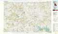 |
Harry S Truman Reservoir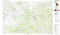 |
Lake Of The Ozarks |
Nevada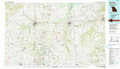 |
Bolivar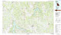 |
Lebanon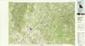 |
Joplin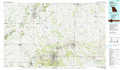 |
Springfield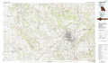 |
Mountain Grove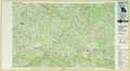 |
> Back to 37092a1 at 1:250,000 scale
> Back to U.S. Topo Maps home
1:24,000 Topo Quads covered by the spatial extent of this 100k map (Bolivar)
|
Tiffin 
|
Roscoe 
|
Vista 
|
Weaubleau 
|
Wheatland 
|
Hermitage 
|
Preston 
|
Branch 
|
|
Filley 
|
Caplinger Mills 
|
Arnica 
|
Humansville 
|
Elkton 
|
Sentinel 
|
Urbana 
|
Tunas 
|
|
Wagoner 
|
Stockton 
|
Bearcreek 
|
Fair Play 
|
Cliquot 
|
Polk 
|
Buffalo Nw 
|
Buffalo 
|
|
Cedarville 
|
Crisp 
|
Bona 
|
Aldrich 
|
Bolivar 
|
Cedar Vista 
|
Half Way 
|
Charity 
|
