Sumner Topo Map Florida
To zoom in, hover over the map of Sumner
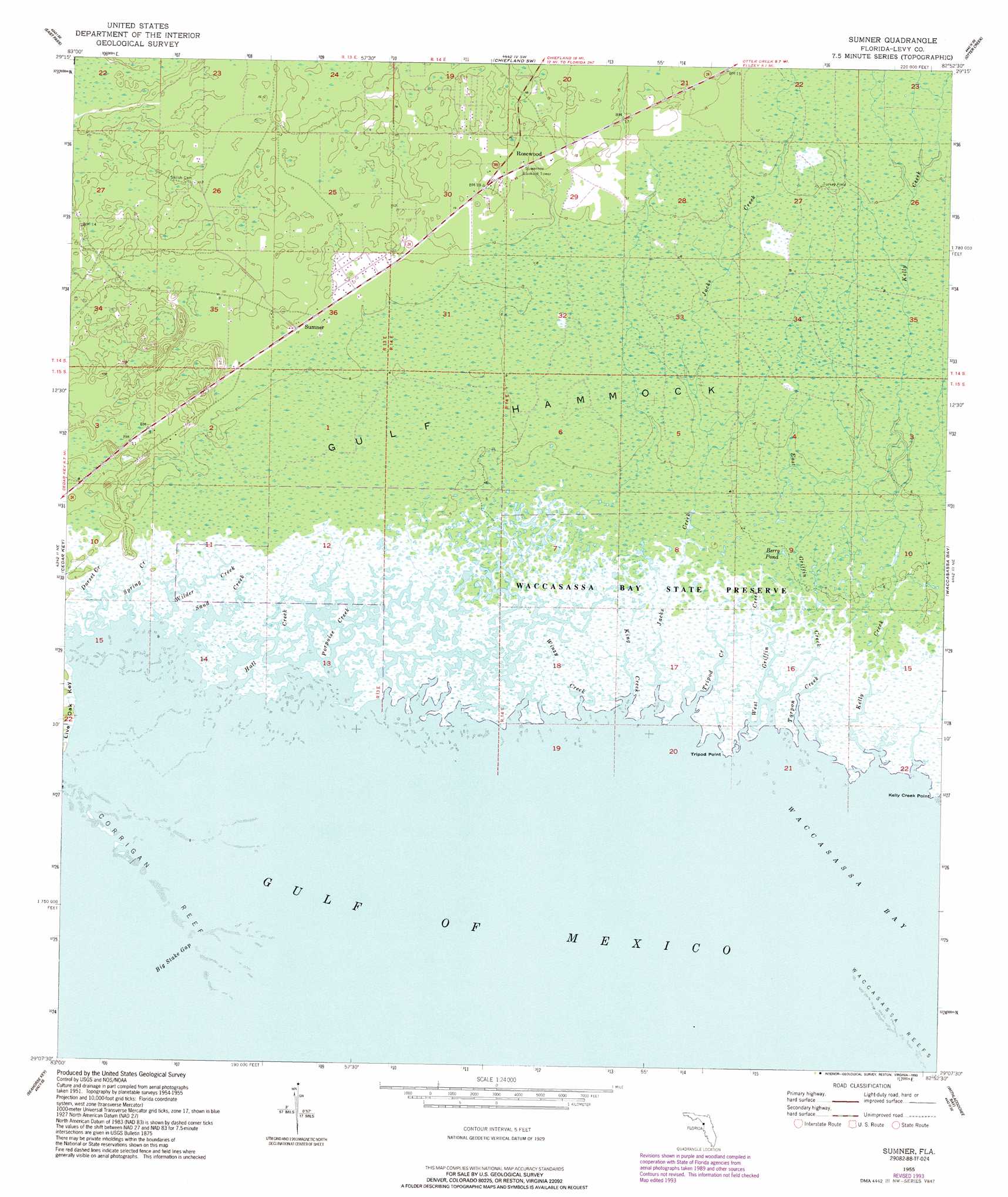
USGS Topo Quad 29082b8 - 1:24,000 scale
| Topo Map Name: | Sumner |
| USGS Topo Quad ID: | 29082b8 |
| Print Size: | ca. 21 1/4" wide x 27" high |
| Southeast Coordinates: | 29.125° N latitude / 82.875° W longitude |
| Map Center Coordinates: | 29.1875° N latitude / 82.9375° W longitude |
| U.S. State: | FL |
| Filename: | O29082B8.jpg |
| Download Map JPG Image: | Sumner topo map 1:24,000 scale |
| Map Type: | Topographic |
| Topo Series: | 7.5´ |
| Map Scale: | 1:24,000 |
| Source of Map Images: | United States Geological Survey (USGS) |
| Alternate Map Versions: |
Sumner FL 1955, updated 1956 Download PDF Buy paper map Sumner FL 1955, updated 1966 Download PDF Buy paper map Sumner FL 1955, updated 1984 Download PDF Buy paper map Sumner FL 1955, updated 1993 Download PDF Buy paper map Sumner FL 2012 Download PDF Buy paper map Sumner FL 2015 Download PDF Buy paper map |
1:24,000 Topo Quads surrounding Sumner
Shired Island |
Vista |
Manatee Springs |
Chiefland |
Bronson |
Suwannee |
East Pass |
Chiefland Sw |
Otter Creek |
Bronson Sw |
Cedar Key |
Sumner |
Waccasassa Bay |
Lebanon Station |
|
Seahorse Key |
Withlacoochee Bay |
Yankeetown |
||
Red Level |
> Back to 29082a1 at 1:100,000 scale
> Back to 29082a1 at 1:250,000 scale
> Back to U.S. Topo Maps home
Sumner topo map: Gazetteer
Sumner: Airports
The Cedars Airfield elevation 3m 9′Sumner: Bars
Corrigan Reef elevation 0m 0′Sumner: Capes
Kelly Creek Point elevation 0m 0′Tripod Point elevation 0m 0′
Sumner: Channels
Big Stake Gap elevation 0m 0′South Bar Channel elevation 0m 0′
Sumner: Lakes
Berry Pond elevation 0m 0′Sumner: Populated Places
Rosewood elevation 5m 16′Sumner elevation 3m 9′
Sumner: Streams
Dorset Creek elevation 0m 0′East Griffin Creek elevation 0m 0′
Hall Creek elevation 0m 0′
Jacks Creek elevation 0m 0′
Kelly Creek elevation 0m 0′
King Creek elevation 0m 0′
Porpoise Creek elevation 0m 0′
Sand Creek elevation 0m 0′
Spring Creek elevation 0m 0′
Tarpon Creek elevation 0m 0′
Tripod Creek elevation 0m 0′
West Griffin Creek elevation 0m 0′
Wilder Creek elevation 0m 0′
Winzy Creek elevation 0m 0′
Sumner digital topo map on disk
Buy this Sumner topo map showing relief, roads, GPS coordinates and other geographical features, as a high-resolution digital map file on DVD: