Geronimo Topo Map Texas
To zoom in, hover over the map of Geronimo
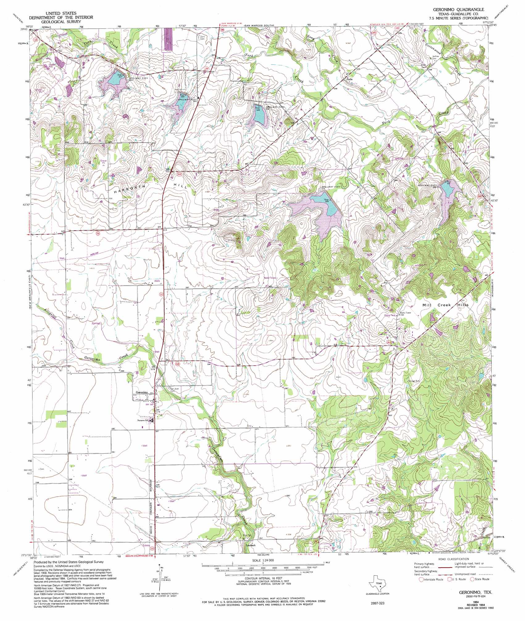
USGS Topo Quad 29097f8 - 1:24,000 scale
| Topo Map Name: | Geronimo |
| USGS Topo Quad ID: | 29097f8 |
| Print Size: | ca. 21 1/4" wide x 27" high |
| Southeast Coordinates: | 29.625° N latitude / 97.875° W longitude |
| Map Center Coordinates: | 29.6875° N latitude / 97.9375° W longitude |
| U.S. State: | TX |
| Filename: | o29097f8.jpg |
| Download Map JPG Image: | Geronimo topo map 1:24,000 scale |
| Map Type: | Topographic |
| Topo Series: | 7.5´ |
| Map Scale: | 1:24,000 |
| Source of Map Images: | United States Geological Survey (USGS) |
| Alternate Map Versions: |
Geronimo TX 1964, updated 1966 Download PDF Buy paper map Geronimo TX 1964, updated 1975 Download PDF Buy paper map Geronimo TX 1964, updated 1994 Download PDF Buy paper map Geronimo TX 2010 Download PDF Buy paper map Geronimo TX 2013 Download PDF Buy paper map Geronimo TX 2016 Download PDF Buy paper map |
1:24,000 Topo Quads surrounding Geronimo
Devils Backbone |
Wimberley |
San Marcos North |
Uhland |
Lockhart North |
Sattler |
Hunter |
San Marcos South |
Martindale |
Lockhart South |
New Braunfels West |
New Braunfels East |
Geronimo |
Kingsbury |
Luling |
Marion |
Mcqueeney |
Seguin |
Darst Creek |
Belmont |
Saint Hedwig |
New Berlin |
Thomas Springs |
Dewville |
Leesville |
> Back to 29097e1 at 1:100,000 scale
> Back to 29096a1 at 1:250,000 scale
> Back to U.S. Topo Maps home
Geronimo topo map: Gazetteer
Geronimo: Airports
Moltz Airport elevation 183m 600′Geronimo: Dams
Soil Conservation Service Site 11 Dam elevation 160m 524′Soil Conservation Service Site 12 Dam elevation 164m 538′
Soil Conservation Service Site 6 Dam elevation 167m 547′
Soil Conservation Service Site 8 Dam elevation 169m 554′
Soil Conservation Service Site 9 Dam elevation 160m 524′
Texas No Name Number 46 Dam elevation 168m 551′
Geronimo: Parks
Silva Park elevation 160m 524′Geronimo: Populated Places
Galle elevation 156m 511′Geronimo elevation 177m 580′
Lauback elevation 162m 531′
Geronimo: Reservoirs
Soil Conservation Service Site 11 Reservoir elevation 160m 524′Soil Conservation Service Site 12 Reservoir elevation 164m 538′
Soil Conservation Service Site 6 Reservoir elevation 167m 547′
Soil Conservation Service Site 8 Reservoir elevation 169m 554′
Soil Conservation Service Site 9 Reservoir elevation 160m 524′
Geronimo: Springs
Geronimo Springs elevation 173m 567′Geronimo: Streams
Alligator Creek elevation 177m 580′Long Creek elevation 140m 459′
Mesquite Creek elevation 158m 518′
Geronimo: Summits
Harborth Hill elevation 214m 702′Geronimo digital topo map on disk
Buy this Geronimo topo map showing relief, roads, GPS coordinates and other geographical features, as a high-resolution digital map file on DVD: