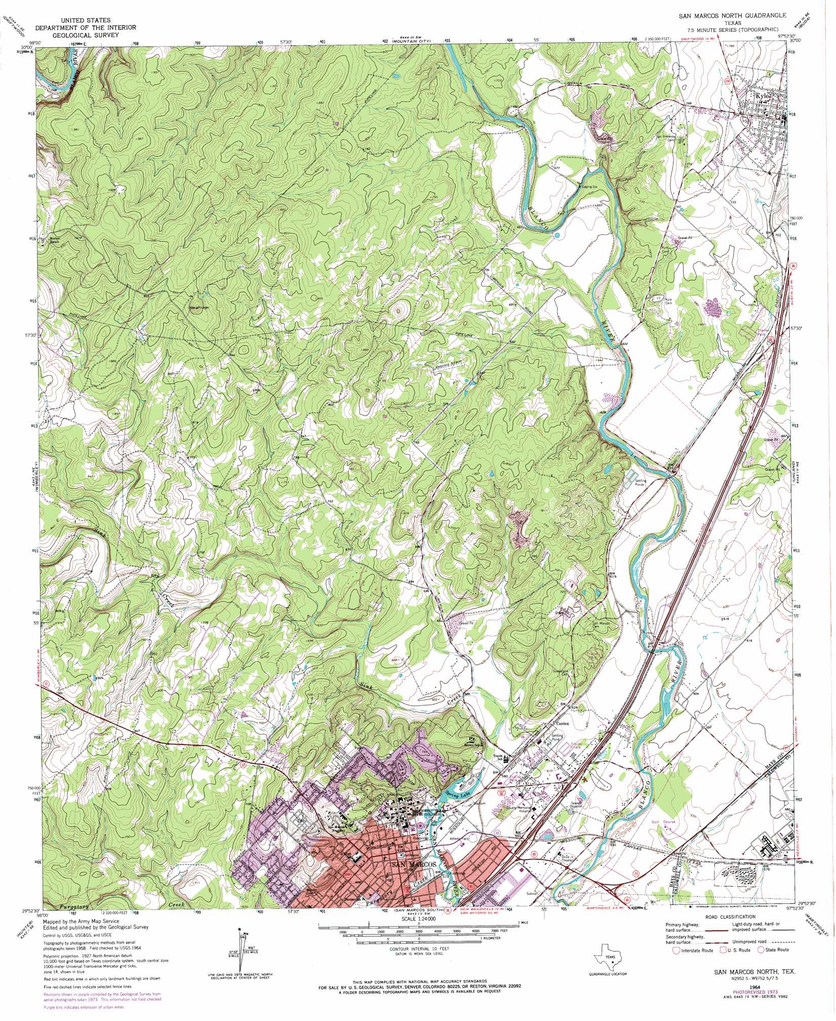
San Marcos North Topo Map Texas
To zoom in, hover over the map of San Marcos North
USGS Topo Quad 29097h8 - 1:24,000 scale
| Topo Map Name: | San Marcos North |
| USGS Topo Quad ID: | 29097h8 |
| Print Size: | ca. 21 1/4" wide x 27" high |
| Southeast Coordinates: | 29.875° N latitude / 97.875° W longitude |
| Map Center Coordinates: | 29.9375° N latitude / 97.9375° W longitude |
| U.S. State: | TX |
| Filename: | o29097h8.jpg |
| Download Map JPG Image: | San Marcos North topo map 1:24,000 scale |
| Map Type: | Topographic |
| Topo Series: | 7.5´ |
| Map Scale: | 1:24,000 |
| Source of Map Images: | United States Geological Survey (USGS) |
| Alternate Map Versions: |
San Marcos North TX 1964, updated 1966 Download PDF Buy paper map San Marcos North TX 1964, updated 1974 Download PDF Buy paper map San Marcos North TX 1964, updated 1974 Download PDF Buy paper map San Marcos North TX 1964, updated 1994 Download PDF Buy paper map San Marcos North TX 1964, updated 1994 Download PDF Buy paper map San Marcos North TX 1995, updated 1998 Download PDF Buy paper map San Marcos North TX 2010 Download PDF Buy paper map San Marcos North TX 2013 Download PDF Buy paper map San Marcos North TX 2016 Download PDF Buy paper map |
1:24,000 Topo Quads surrounding San Marcos North
Henly |
Dripping Springs |
Signal Hill |
Oak Hill |
Montopolis |
Rough Hollow |
Driftwood |
Mountain City |
Buda |
Creedmoor |
Devils Backbone |
Wimberley |
San Marcos North |
Uhland |
Lockhart North |
Sattler |
Hunter |
San Marcos South |
Martindale |
Lockhart South |
New Braunfels West |
New Braunfels East |
Geronimo |
Kingsbury |
Luling |
> Back to 29097e1 at 1:100,000 scale
> Back to 29096a1 at 1:250,000 scale
> Back to U.S. Topo Maps home
San Marcos North topo map: Gazetteer
San Marcos North: Airports
Wyatt Airport elevation 273m 895′San Marcos North: Dams
Aquarena Dam elevation 174m 570′Hays County Park Lake Dam elevation 184m 603′
San Marcos North: Parks
Baptist Academy San Marocs Baseball Field elevation 253m 830′Bobcat Baseball Field elevation 176m 577′
Bobcat Soccer Complex elevation 234m 767′
Bobcat Softball Field elevation 177m 580′
Bobcat Stadium elevation 177m 580′
Ramon Lucio Memorial Park elevation 174m 570′
Rio Vista Park elevation 174m 570′
San Marcos City Park elevation 174m 570′
Strahan Coliseum elevation 175m 574′
San Marcos North: Populated Places
Centex elevation 189m 620′Kyle elevation 222m 728′
San Marcos elevation 188m 616′
San Marcos North: Reservoirs
Hays County Park Lake elevation 184m 603′Spring Lake elevation 175m 574′
San Marcos North: Springs
San Marcos Spring elevation 195m 639′Weismuller Spring elevation 176m 577′
San Marcos North: Streams
Purgatory Creek elevation 174m 570′Sink Creek elevation 177m 580′
San Marcos North: Trails
Prospect Park Trail elevation 195m 639′San Marcos Riverwalk elevation 173m 567′
San Marcos North digital topo map on disk
Buy this San Marcos North topo map showing relief, roads, GPS coordinates and other geographical features, as a high-resolution digital map file on DVD: