Avent Topo Map Mississippi
To zoom in, hover over the map of Avent
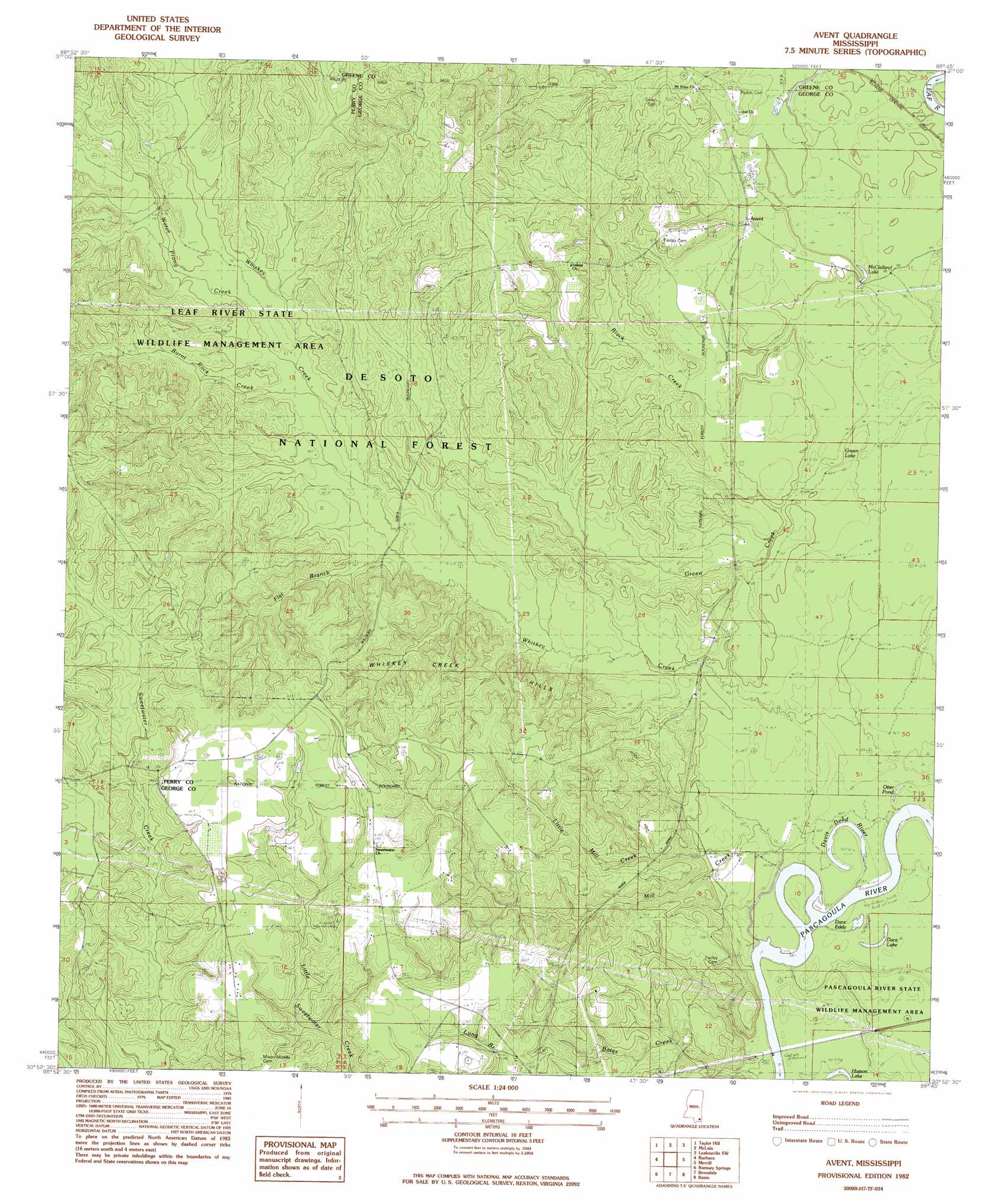
USGS Topo Quad 30088h7 - 1:24,000 scale
| Topo Map Name: | Avent |
| USGS Topo Quad ID: | 30088h7 |
| Print Size: | ca. 21 1/4" wide x 27" high |
| Southeast Coordinates: | 30.875° N latitude / 88.75° W longitude |
| Map Center Coordinates: | 30.9375° N latitude / 88.8125° W longitude |
| U.S. State: | MS |
| Filename: | o30088h7.jpg |
| Download Map JPG Image: | Avent topo map 1:24,000 scale |
| Map Type: | Topographic |
| Topo Series: | 7.5´ |
| Map Scale: | 1:24,000 |
| Source of Map Images: | United States Geological Survey (USGS) |
| Alternate Map Versions: |
Avent MS 1982, updated 1982 Download PDF Buy paper map Avent MS 2000, updated 2003 Download PDF Buy paper map Avent MS 2012 Download PDF Buy paper map Avent MS 2015 Download PDF Buy paper map |
| FStopo: | US Forest Service topo Avent is available: Download FStopo PDF Download FStopo TIF |
1:24,000 Topo Quads surrounding Avent
New Augusta |
Beaumont |
Neely |
Jonathan |
Leakesville |
Janice |
Taylor Hill |
Mclain |
Leakesville Sw |
Vernal |
Bond Pond |
Barbara |
Avent |
Merrill |
Lucedale |
Whites Crossing |
Ramsey Springs |
Benndale |
Basin |
Agricola |
Airey |
Beatrice |
Vestry |
Easen Hill |
Harleston |
> Back to 30088e1 at 1:100,000 scale
> Back to 30088a1 at 1:250,000 scale
> Back to U.S. Topo Maps home
Avent topo map: Gazetteer
Avent: Bays
Dace Eddy elevation 9m 29′Avent: Crossings
Fairley Ferry (historical) elevation 9m 29′Avent: Lakes
Black Lake elevation 13m 42′Dace Lake elevation 9m 29′
Davis Dead River elevation 9m 29′
Green Lake elevation 12m 39′
McClelland Lake elevation 15m 49′
Otter Pond elevation 10m 32′
Avent: Populated Places
Avent elevation 18m 59′Avent: Streams
Black Creek elevation 12m 39′Burnt Rock Creek elevation 27m 88′
Flat Branch elevation 23m 75′
Green Creek elevation 12m 39′
Little Mill Creek elevation 13m 42′
Mill Creek elevation 9m 29′
Water Prong Creek elevation 27m 88′
Whiskey Creek elevation 9m 29′
Avent: Summits
Whiskey Creek Hills elevation 42m 137′Avent digital topo map on disk
Buy this Avent topo map showing relief, roads, GPS coordinates and other geographical features, as a high-resolution digital map file on DVD:
Gulf Coast (LA, MS, AL, FL) & Southwestern Georgia
Buy digital topo maps: Gulf Coast (LA, MS, AL, FL) & Southwestern Georgia
 & Southwestern Georgia map DVD")