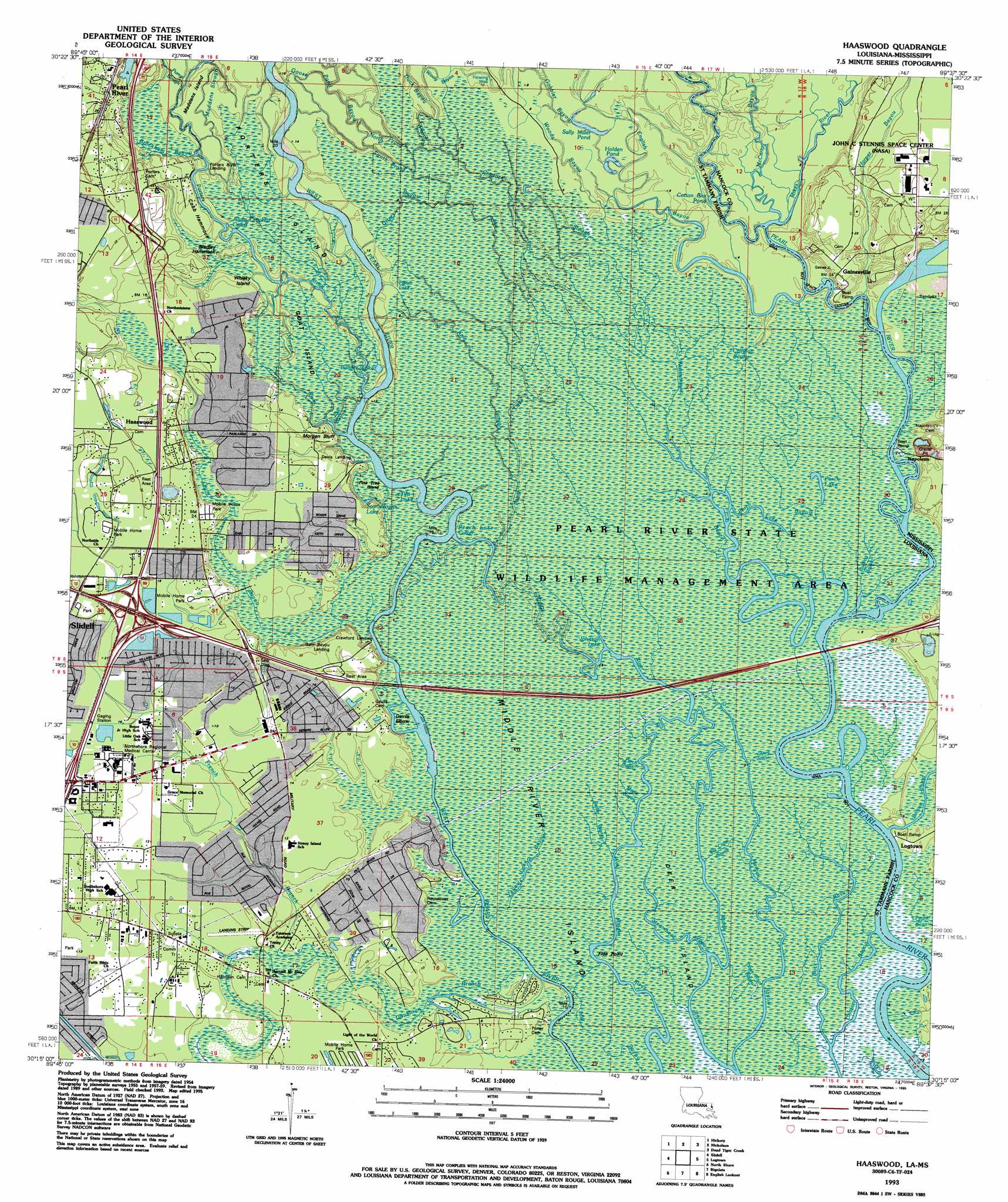
Haaswood Topo Map Louisiana
To zoom in, hover over the map of Haaswood
USGS Topo Quad 30089c6 - 1:24,000 scale
| Topo Map Name: | Haaswood |
| USGS Topo Quad ID: | 30089c6 |
| Print Size: | ca. 21 1/4" wide x 27" high |
| Southeast Coordinates: | 30.25° N latitude / 89.625° W longitude |
| Map Center Coordinates: | 30.3125° N latitude / 89.6875° W longitude |
| U.S. States: | LA, MS |
| Filename: | o30089c6.jpg |
| Download Map JPG Image: | Haaswood topo map 1:24,000 scale |
| Map Type: | Topographic |
| Topo Series: | 7.5´ |
| Map Scale: | 1:24,000 |
| Source of Map Images: | United States Geological Survey (USGS) |
| Alternate Map Versions: |
Haaswood LA 1959, updated 1960 Download PDF Buy paper map Haaswood LA 1959, updated 1963 Download PDF Buy paper map Haaswood LA 1959, updated 1971 Download PDF Buy paper map Haaswood LA 1959, updated 1978 Download PDF Buy paper map Haaswood LA 1993, updated 1995 Download PDF Buy paper map Haaswood LA 1993, updated 1995 Download PDF Buy paper map Haaswood LA 1998, updated 2000 Download PDF Buy paper map Haaswood LA 2012 Download PDF Buy paper map Haaswood LA 2015 Download PDF Buy paper map |
1:24,000 Topo Quads surrounding Haaswood
Bush |
Industrial |
Picayune |
Caesar |
Necaise |
Saint Tammany |
Hickory |
Nicholson |
Dead Tiger Creek |
Kiln |
Lacombe |
Slidell |
Haaswood |
Logtown |
Waveland |
South Point |
North Shore |
Rigolets |
English Lookout |
Grand Island Pass |
Little Woods |
Chef Menteur |
Alligator Point |
False Mouth Bayou |
Malheureux Point |
> Back to 30089a1 at 1:100,000 scale
> Back to 30088a1 at 1:250,000 scale
> Back to U.S. Topo Maps home
Haaswood topo map: Gazetteer
Haaswood: Airports
Northshore Regional Medical Center Heliport elevation 4m 13′Haaswood: Areas
Bradley Hammock elevation 3m 9′Cobb Hammock elevation 6m 19′
Deer Island elevation 0m 0′
Haaswood: Bends
Andy Crockett Cutoff elevation 3m 9′Devils Elbow elevation 2m 6′
Peach Lake Cutoff elevation 2m 6′
Haaswood: Canals
Carys Ditch elevation 0m 0′Yellow Lake Bayou elevation 1m 3′
Haaswood: Capes
Flea Point elevation 0m 0′Haaswood: Crossings
Interchange 1 elevation 8m 26′Interchange 266 elevation 6m 19′
Interchange 267 elevation 7m 22′
Interchange 3 elevation 7m 22′
Interchange 85 elevation 7m 22′
Haaswood: Guts
Calhoun Bayou elevation 1m 3′Parish Lake elevation 3m 9′
Parker Bayou elevation 0m 0′
Haaswood: Islands
Goat Island elevation 3m 9′Maddens Island elevation 4m 13′
Middle River Island elevation 0m 0′
Pine Tree Island elevation 2m 6′
Porters Island elevation 3m 9′
Whisky Island elevation 3m 9′
Haaswood: Lakes
Banks Lake elevation 3m 9′Bullock Lake elevation 3m 9′
Cotton Box Pond elevation 1m 3′
Holden Pond elevation 1m 3′
Johnson Lake elevation 1m 3′
Little Lake elevation 1m 3′
Perch Lake elevation 0m 0′
Sally Miller Pond elevation 1m 3′
Scarborough Lake elevation 3m 9′
Tifts Lake elevation 2m 6′
Haaswood: Populated Places
Abney Country Air elevation 3m 9′Bel Air elevation 2m 6′
Crawford Landing elevation 5m 16′
Cross Gates elevation 4m 13′
Davis Landing elevation 4m 13′
Doubloon Bayou Estates elevation 1m 3′
Foxhollow elevation 2m 6′
French Branch Estates elevation 2m 6′
Frenchmens Estates elevation 3m 9′
Gainesville elevation 7m 22′
Gum Bayou Landing elevation 2m 6′
Haaswood elevation 7m 22′
Hickory Hills elevation 3m 9′
Holiday Acres elevation 4m 13′
Lake Village elevation 4m 13′
Lindberg Glen elevation 3m 9′
Magnolia Forest elevation 4m 13′
Morgan Bluff elevation 3m 9′
Napoleon elevation 5m 16′
Oak Grove Estates elevation 7m 22′
Ozone Pines elevation 6m 19′
Pearl Acres elevation 4m 13′
Pecan Grove elevation 6m 19′
Porters River Landing elevation 4m 13′
Quail Ridge elevation 3m 9′
River Gardens elevation 3m 9′
River Oaks elevation 2m 6′
Rivercrest elevation 4m 13′
Riverview Addition elevation 4m 13′
Robert Park elevation 4m 13′
The Settlement elevation 3m 9′
Timber Lake Estates elevation 3m 9′
Willow Wood elevation 4m 13′
Haaswood: Streams
Big Cross Bayou elevation 0m 0′Bill Ed Bayou elevation 3m 9′
Bogue Homa elevation 1m 3′
Brockham Bayou elevation 4m 13′
Buck Bayou elevation 0m 0′
Bulfrog Bayou elevation 0m 0′
Bull Bayou elevation 3m 9′
Cradock Slough elevation 0m 0′
Doubloon Branch elevation 1m 3′
Duck Bayou elevation 2m 6′
English Bayou elevation 1m 3′
Fish Bayou elevation 3m 9′
French Branch elevation 1m 3′
Gobbler Bayou elevation 1m 3′
Goose Pond Bayou elevation 4m 13′
Gum Bayou elevation 2m 6′
Harper Bayou elevation 1m 3′
Kale Slough elevation 2m 6′
Maddens Slough elevation 4m 13′
Maple Bayou elevation 0m 0′
McCarty Bayou elevation 0m 0′
Morgan Bayou elevation 0m 0′
Morgan River elevation 3m 9′
North Prong Goose Pond Bayou elevation 2m 6′
Otter Bayou elevation 3m 9′
Parker Bayou elevation 0m 0′
Peach Lake elevation 2m 6′
Perch Bayou elevation 0m 0′
Perch Lake Bayou elevation 0m 0′
Porters River elevation 3m 9′
Pump Slough elevation 4m 13′
South Prong Goose Pond Bayou elevation 2m 6′
Steamboat Bayou elevation 0m 0′
Three Knot Bayou elevation 0m 0′
Wastehouse Bayou elevation 0m 0′
Woods Bayou elevation 2m 6′
Wooly Bayou elevation 2m 6′
Haaswood digital topo map on disk
Buy this Haaswood topo map showing relief, roads, GPS coordinates and other geographical features, as a high-resolution digital map file on DVD:
Gulf Coast (LA, MS, AL, FL) & Southwestern Georgia
Buy digital topo maps: Gulf Coast (LA, MS, AL, FL) & Southwestern Georgia
 & Southwestern Georgia map DVD")