Slidell Topo Map Louisiana
To zoom in, hover over the map of Slidell
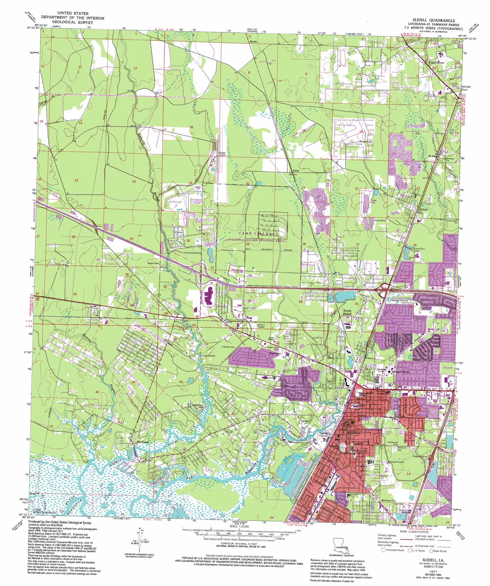
USGS Topo Quad 30089c7 - 1:24,000 scale
| Topo Map Name: | Slidell |
| USGS Topo Quad ID: | 30089c7 |
| Print Size: | ca. 21 1/4" wide x 27" high |
| Southeast Coordinates: | 30.25° N latitude / 89.75° W longitude |
| Map Center Coordinates: | 30.3125° N latitude / 89.8125° W longitude |
| U.S. State: | LA |
| Filename: | o30089c7.jpg |
| Download Map JPG Image: | Slidell topo map 1:24,000 scale |
| Map Type: | Topographic |
| Topo Series: | 7.5´ |
| Map Scale: | 1:24,000 |
| Source of Map Images: | United States Geological Survey (USGS) |
| Alternate Map Versions: |
Slidell LA 1971, updated 1972 Download PDF Buy paper map Slidell LA 1971, updated 1980 Download PDF Buy paper map Slidell LA 1971, updated 1984 Download PDF Buy paper map Slidell LA 1971, updated 1991 Download PDF Buy paper map Slidell LA 1971, updated 1994 Download PDF Buy paper map Slidell LA 1998, updated 2002 Download PDF Buy paper map Slidell LA 2012 Download PDF Buy paper map Slidell LA 2015 Download PDF Buy paper map |
1:24,000 Topo Quads surrounding Slidell
Waldheim |
Bush |
Industrial |
Picayune |
Caesar |
Covington |
Saint Tammany |
Hickory |
Nicholson |
Dead Tiger Creek |
Mandeville |
Lacombe |
Slidell |
Haaswood |
Logtown |
Spanish Fort Ne |
South Point |
North Shore |
Rigolets |
English Lookout |
Spanish Fort |
Little Woods |
Chef Menteur |
Alligator Point |
False Mouth Bayou |
> Back to 30089a1 at 1:100,000 scale
> Back to 30088a1 at 1:250,000 scale
> Back to U.S. Topo Maps home
Slidell topo map: Gazetteer
Slidell: Airports
Slidell Airport elevation 8m 26′Slidell Memorial Hospital Heliport elevation 4m 13′
Slidell: Crossings
Guzmans Ferry (historical) elevation 0m 0′Interchange 80 elevation 5m 16′
Interchange 83 elevation 5m 16′
Slidell: Parks
Possum Hollow Park elevation 2m 6′Slidell: Populated Places
Abney Estates elevation 2m 6′Acadian Estates elevation 3m 9′
Alton elevation 8m 26′
Amos elevation 7m 22′
Audubon Place elevation 5m 16′
Audubon Place Plaza elevation 5m 16′
Bayou Bend elevation 2m 6′
Bayou Bonfouca Estates elevation 0m 0′
Bayou Liberty Estates elevation 2m 6′
Bayou Liberty Gardens elevation 3m 9′
Bayou Oaks elevation 1m 3′
Bayou Paquet Estates elevation 3m 9′
Bayou Terrace elevation 1m 3′
Bayou Vincent elevation 3m 9′
Bayou Vista elevation 2m 6′
Beachview elevation 2m 6′
Bell Terre Acres elevation 2m 6′
Belvedere Estates elevation 3m 9′
Beverly Hills elevation 3m 9′
Bon Village elevation 4m 13′
Bonfouca elevation 1m 3′
Broadmoor elevation 4m 13′
Brookwood Estates elevation 5m 16′
Browns Village elevation 5m 16′
Brugier elevation 3m 9′
Cadillac Park elevation 5m 16′
Carolyn Park elevation 3m 9′
Castle Manor elevation 5m 16′
Central Park elevation 3m 9′
Chamale Cove elevation 1m 3′
Charleston Square elevation 4m 13′
Christi Ann Lea elevation 2m 6′
Coin Du Lestin elevation 1m 3′
Colt elevation 4m 13′
Country Club Estates elevation 6m 19′
Country Manor elevation 5m 16′
Delwood elevation 1m 3′
Eastridge elevation 3m 9′
Elysian Acres elevation 3m 9′
Forest Manor elevation 5m 16′
Forest Pines elevation 2m 6′
Fountain Park elevation 2m 6′
Fountainbleau elevation 1m 3′
Heritage Subdivision elevation 4m 13′
Hermedel elevation 2m 6′
Home Estates elevation 4m 13′
Huntington Estates elevation 3m 9′
Huntwyck Village elevation 4m 13′
Hyde Park elevation 5m 16′
Kimberly Manor elevation 2m 6′
Kings Point elevation 3m 9′
Lake Shore Village elevation 1m 3′
Lakewood elevation 4m 13′
Liberty Acres elevation 1m 3′
Liberty Pines elevation 1m 3′
Lincoln Park elevation 1m 3′
Magnolia Heights elevation 2m 6′
Maude elevation 10m 32′
McClane City elevation 3m 9′
Morgans elevation 6m 19′
New Country Club elevation 6m 19′
North End elevation 3m 9′
North Slidell elevation 4m 13′
Northwood Village elevation 6m 19′
Noth Forest elevation 6m 19′
Oak Manor Estates elevation 4m 13′
Oak Ridge elevation 2m 6′
Oakmont elevation 6m 19′
Oakwood elevation 2m 6′
Ozone Acres elevation 2m 6′
Ozone Woods elevation 4m 13′
Palm Lake elevation 1m 3′
Park Place elevation 2m 6′
Pine Forest elevation 3m 9′
Pine Shadows elevation 4m 13′
Pinecrest elevation 3m 9′
Piney Ridge Park elevation 3m 9′
Regal Park Estates elevation 6m 19′
Royal Estates elevation 6m 19′
Saint Joe elevation 9m 29′
Saint Tammany Garden Meadows elevation 5m 16′
Salmen elevation 1m 3′
Slidell elevation 1m 3′
Slidell Heights elevation 3m 9′
Slidell Manor elevation 4m 13′
Slidell Ozone Heights elevation 5m 16′
Tanglewood Village elevation 6m 19′
The Woods elevation 2m 6′
Timber Ridge elevation 4m 13′
Village North elevation 3m 9′
West Hall Park elevation 3m 9′
Whisperwood Estates elevation 7m 22′
Wimbledon Estates elevation 3m 9′
Woodlawn Acres elevation 4m 13′
Slidell: Post Offices
Slidell Post Office elevation 2m 6′Slidell: Streams
Bayou du Chien elevation 0m 0′Bayou Paquet elevation -1m -4′
Bayou Patassat elevation 0m 0′
Bayou Vincent elevation 2m 6′
Liberty Bayou elevation 0m 0′
Slidell digital topo map on disk
Buy this Slidell topo map showing relief, roads, GPS coordinates and other geographical features, as a high-resolution digital map file on DVD:
Gulf Coast (LA, MS, AL, FL) & Southwestern Georgia
Buy digital topo maps: Gulf Coast (LA, MS, AL, FL) & Southwestern Georgia
 & Southwestern Georgia map DVD")