Clopton Topo Map Alabama
To zoom in, hover over the map of Clopton
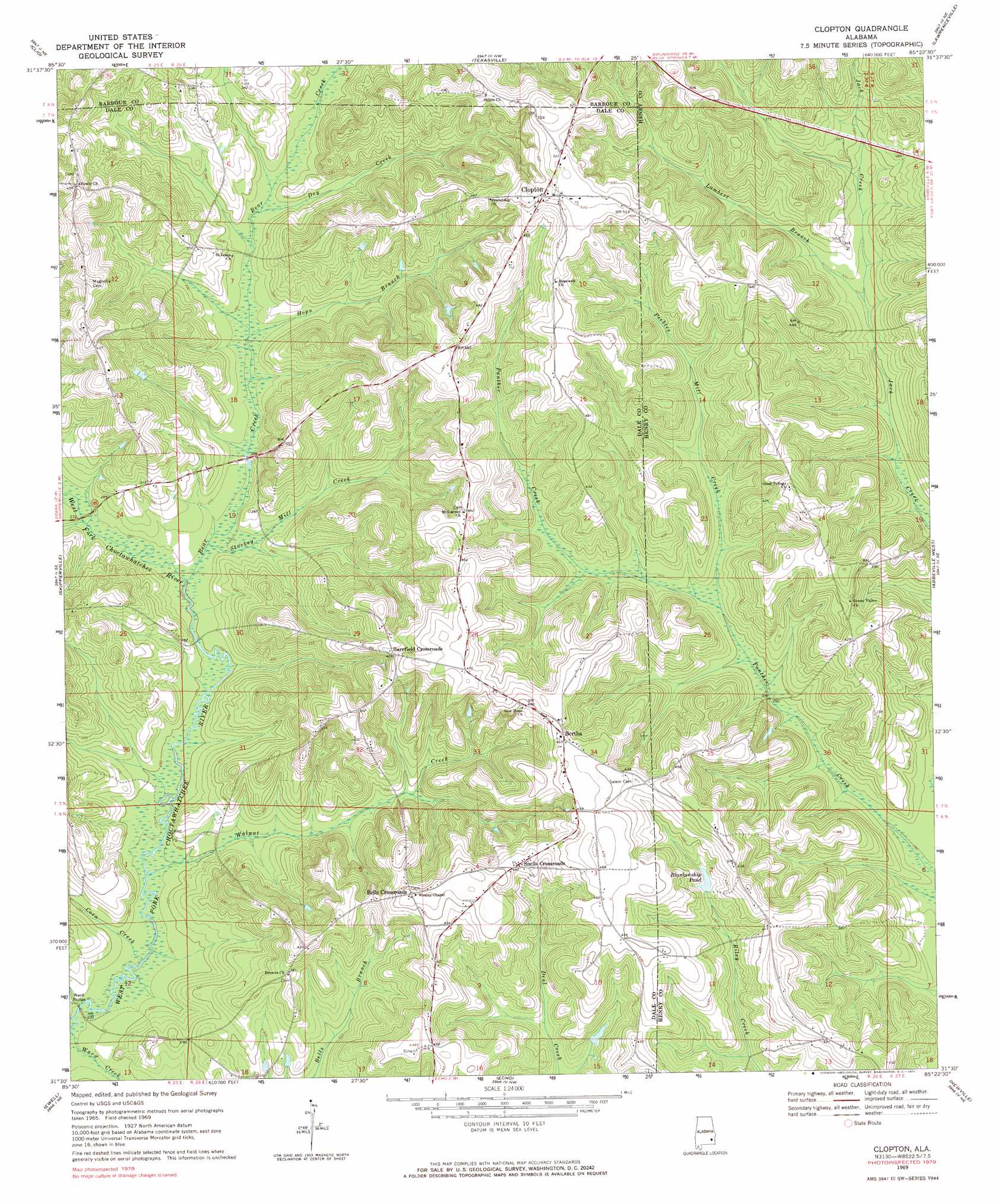
USGS Topo Quad 31085e4 - 1:24,000 scale
| Topo Map Name: | Clopton |
| USGS Topo Quad ID: | 31085e4 |
| Print Size: | ca. 21 1/4" wide x 27" high |
| Southeast Coordinates: | 31.5° N latitude / 85.375° W longitude |
| Map Center Coordinates: | 31.5625° N latitude / 85.4375° W longitude |
| U.S. State: | AL |
| Filename: | o31085e4.jpg |
| Download Map JPG Image: | Clopton topo map 1:24,000 scale |
| Map Type: | Topographic |
| Topo Series: | 7.5´ |
| Map Scale: | 1:24,000 |
| Source of Map Images: | United States Geological Survey (USGS) |
| Alternate Map Versions: |
Clopton AL 1969, updated 1971 Download PDF Buy paper map Clopton AL 1969, updated 1971 Download PDF Buy paper map Clopton AL 2011 Download PDF Buy paper map Clopton AL 2014 Download PDF Buy paper map |
1:24,000 Topo Quads surrounding Clopton
Josie |
Louisville |
Clayton South |
Baker Hill |
Eufaula South |
Elamville |
Clio |
Texasville |
Lawrenceville |
Fort Gaines Nw |
Ariton |
Skipperville |
Clopton |
Abbeville West |
Abbeville East |
Ozark |
Ewell |
Echo |
Newville |
Haleburg |
Daleville |
Pinckard |
Midland City |
Headland |
Sigma |
> Back to 31085e1 at 1:100,000 scale
> Back to 31084a1 at 1:250,000 scale
> Back to U.S. Topo Maps home
Clopton topo map: Gazetteer
Clopton: Bridges
Monks Mill Bridge elevation 76m 249′Ward Bridge elevation 69m 226′
Clopton: Dams
G B Blankenship Dam elevation 110m 360′Clopton: Populated Places
Barefield Crossroads elevation 132m 433′Bells Crossroads elevation 143m 469′
Bertha elevation 142m 465′
Clopton elevation 154m 505′
Snells Crossroads elevation 135m 442′
Clopton: Post Offices
Clopton Post Office elevation 155m 508′Clopton: Reservoirs
Blankenship Pond elevation 110m 360′Clopton: Streams
Bear Creek elevation 76m 249′Corn Creek elevation 70m 229′
Dry Creek elevation 86m 282′
Hopn Branch elevation 82m 269′
Lambert Branch elevation 94m 308′
Peebles Mill Creek elevation 92m 301′
Stuckey Mill Creek elevation 79m 259′
Walnut Creek elevation 74m 242′
Ward Creek elevation 69m 226′
Clopton digital topo map on disk
Buy this Clopton topo map showing relief, roads, GPS coordinates and other geographical features, as a high-resolution digital map file on DVD:
Gulf Coast (LA, MS, AL, FL) & Southwestern Georgia
Buy digital topo maps: Gulf Coast (LA, MS, AL, FL) & Southwestern Georgia
 & Southwestern Georgia map DVD")