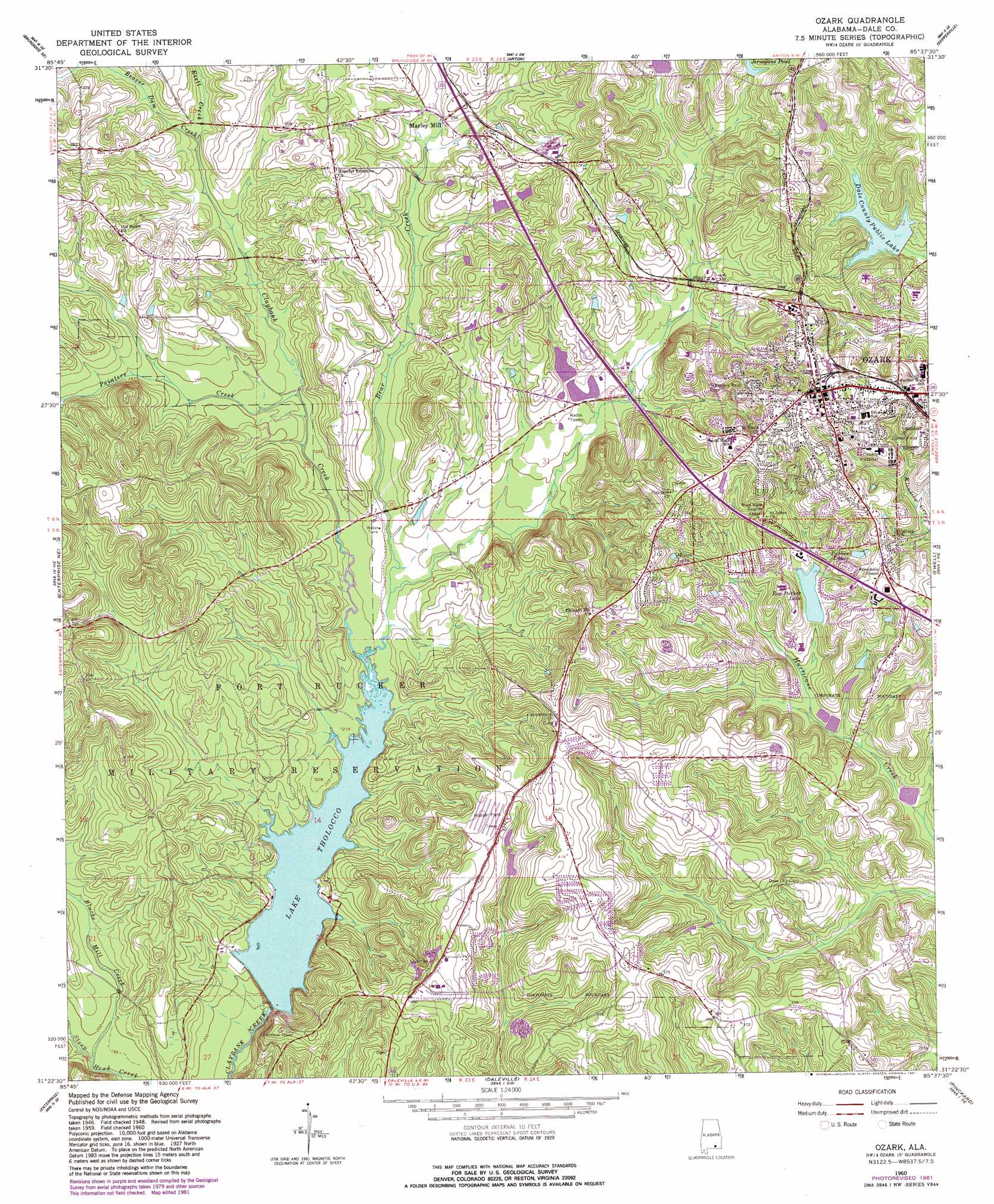
Ozark Topo Map Alabama
To zoom in, hover over the map of Ozark
USGS Topo Quad 31085d6 - 1:24,000 scale
| Topo Map Name: | Ozark |
| USGS Topo Quad ID: | 31085d6 |
| Print Size: | ca. 21 1/4" wide x 27" high |
| Southeast Coordinates: | 31.375° N latitude / 85.625° W longitude |
| Map Center Coordinates: | 31.4375° N latitude / 85.6875° W longitude |
| U.S. State: | AL |
| Filename: | o31085d6.jpg |
| Download Map JPG Image: | Ozark topo map 1:24,000 scale |
| Map Type: | Topographic |
| Topo Series: | 7.5´ |
| Map Scale: | 1:24,000 |
| Source of Map Images: | United States Geological Survey (USGS) |
| Alternate Map Versions: |
Ozark AL 1960, updated 1964 Download PDF Buy paper map Ozark AL 1960, updated 1981 Download PDF Buy paper map Ozark AL 2011 Download PDF Buy paper map Ozark AL 2014 Download PDF Buy paper map |
1:24,000 Topo Quads surrounding Ozark
Brundidge Nw |
Brundidge |
Elamville |
Clio |
Texasville |
Victoria |
Brundidge Se |
Ariton |
Skipperville |
Clopton |
New Brockton |
Enterprise Ne |
Ozark |
Ewell |
Echo |
Goodman |
Enterprise |
Daleville |
Pinckard |
Midland City |
Coffee Springs |
Bellwood |
Clayhatchee |
Malvern |
Dothan West |
> Back to 31085a1 at 1:100,000 scale
> Back to 31084a1 at 1:250,000 scale
> Back to U.S. Topo Maps home
Ozark topo map: Gazetteer
Ozark: Airports
Hooper Field elevation 113m 370′Ozark: Bridges
Byrd Bridge elevation 67m 219′Martin Bridge (historical) elevation 62m 203′
Marvin E Parker Bridge elevation 114m 374′
Ozark: Dams
C A Jernigan Lake Dam elevation 107m 351′D A Deloney Lake Dam Number 2 elevation 81m 265′
D A Delony Dam elevation 81m 265′
Dale County Public Lake Dam elevation 96m 314′
Lake Tholloco Dam elevation 64m 209′
Marvin Parker Lake Dam Number 1 elevation 101m 331′
Roy Parker Lake Dam elevation 90m 295′
Ozark: Parks
Comer Field elevation 113m 370′Sam Dale Park elevation 99m 324′
Ozark: Populated Places
Marley Mill elevation 79m 259′Ozark elevation 127m 416′
Pleasant Hill elevation 123m 403′
Ozark: Reservoirs
D A Deloney Lake Number One elevation 81m 265′D A Deloney Lake Number Two elevation 81m 265′
Dale County Public Lake elevation 95m 311′
Jernegans Pond elevation 107m 351′
Lake Tholocco elevation 64m 209′
Marley Millpond elevation 82m 269′
Marvin Parker Lake Number One elevation 101m 331′
Mixon Lake elevation 96m 314′
Parker Lakes elevation 92m 301′
Roy Parker Lake elevation 84m 275′
Williams Lake elevation 101m 331′
Ozark: Streams
Bear Creek elevation 67m 219′Beaver Branch elevation 66m 216′
Beaverdam Creek elevation 77m 252′
Blacks Mill Creek elevation 58m 190′
Little Claybank Creek elevation 67m 219′
Painters Creek elevation 67m 219′
Ozark digital topo map on disk
Buy this Ozark topo map showing relief, roads, GPS coordinates and other geographical features, as a high-resolution digital map file on DVD:
Gulf Coast (LA, MS, AL, FL) & Southwestern Georgia
Buy digital topo maps: Gulf Coast (LA, MS, AL, FL) & Southwestern Georgia
 & Southwestern Georgia map DVD")