Bradley Topo Map Alabama
To zoom in, hover over the map of Bradley
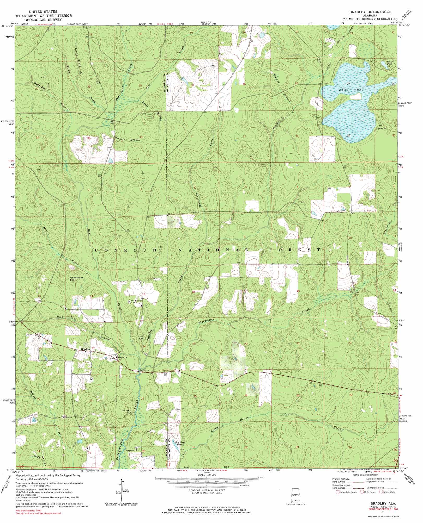
USGS Topo Quad 31086a6 - 1:24,000 scale
| Topo Map Name: | Bradley |
| USGS Topo Quad ID: | 31086a6 |
| Print Size: | ca. 21 1/4" wide x 27" high |
| Southeast Coordinates: | 31° N latitude / 86.625° W longitude |
| Map Center Coordinates: | 31.0625° N latitude / 86.6875° W longitude |
| U.S. State: | AL |
| Filename: | o31086a6.jpg |
| Download Map JPG Image: | Bradley topo map 1:24,000 scale |
| Map Type: | Topographic |
| Topo Series: | 7.5´ |
| Map Scale: | 1:24,000 |
| Source of Map Images: | United States Geological Survey (USGS) |
| Alternate Map Versions: |
Bradley AL 1971, updated 1972 Download PDF Buy paper map Bradley AL 1971, updated 1984 Download PDF Buy paper map Bradley AL 2011 Download PDF Buy paper map Bradley AL 2014 Download PDF Buy paper map |
| FStopo: | US Forest Service topo Bradley is available: Download FStopo PDF Download FStopo TIF |
1:24,000 Topo Quads surrounding Bradley
Nymph |
Brooklyn |
Loango |
River Falls |
Andalusia |
Shipps Creek |
Damascus |
Dixie |
Carolina |
Libertyville |
Roberts |
Parker Springs |
Bradley |
Wing |
Watkins Bridge |
Mclellan |
Hurricane Lake |
Blackman |
Oak Grove |
Laurel Hill |
Spring Hill |
Munson |
Baker |
Crestview North |
Dorcas |
> Back to 31086a1 at 1:100,000 scale
> Back to 31086a1 at 1:250,000 scale
> Back to U.S. Topo Maps home
Bradley topo map: Gazetteer
Bradley: Capes
Sand Point elevation 67m 219′Bradley: Populated Places
Bradley elevation 66m 216′Bradley: Reservoirs
Otter Pond elevation 69m 226′Roy Cook Ponds elevation 52m 170′
Bradley: Streams
Bear Creek elevation 39m 127′Bear Head Creek elevation 52m 170′
Blackwater Creek elevation 39m 127′
Fish Trap Branch elevation 39m 127′
Hickory Branch elevation 52m 170′
Hurricane Creek elevation 50m 164′
Little Reedy Creek elevation 56m 183′
Miller Creek elevation 44m 144′
Panther Creek elevation 39m 127′
Pauls Branch elevation 54m 177′
Reedy Creek elevation 54m 177′
Walnut Branch elevation 62m 203′
Wolf Pit Branch elevation 51m 167′
Bradley: Summits
Sandstone Hill elevation 73m 239′Bradley: Swamps
Bear Bay elevation 66m 216′Bradley digital topo map on disk
Buy this Bradley topo map showing relief, roads, GPS coordinates and other geographical features, as a high-resolution digital map file on DVD:
Gulf Coast (LA, MS, AL, FL) & Southwestern Georgia
Buy digital topo maps: Gulf Coast (LA, MS, AL, FL) & Southwestern Georgia
 & Southwestern Georgia map DVD")