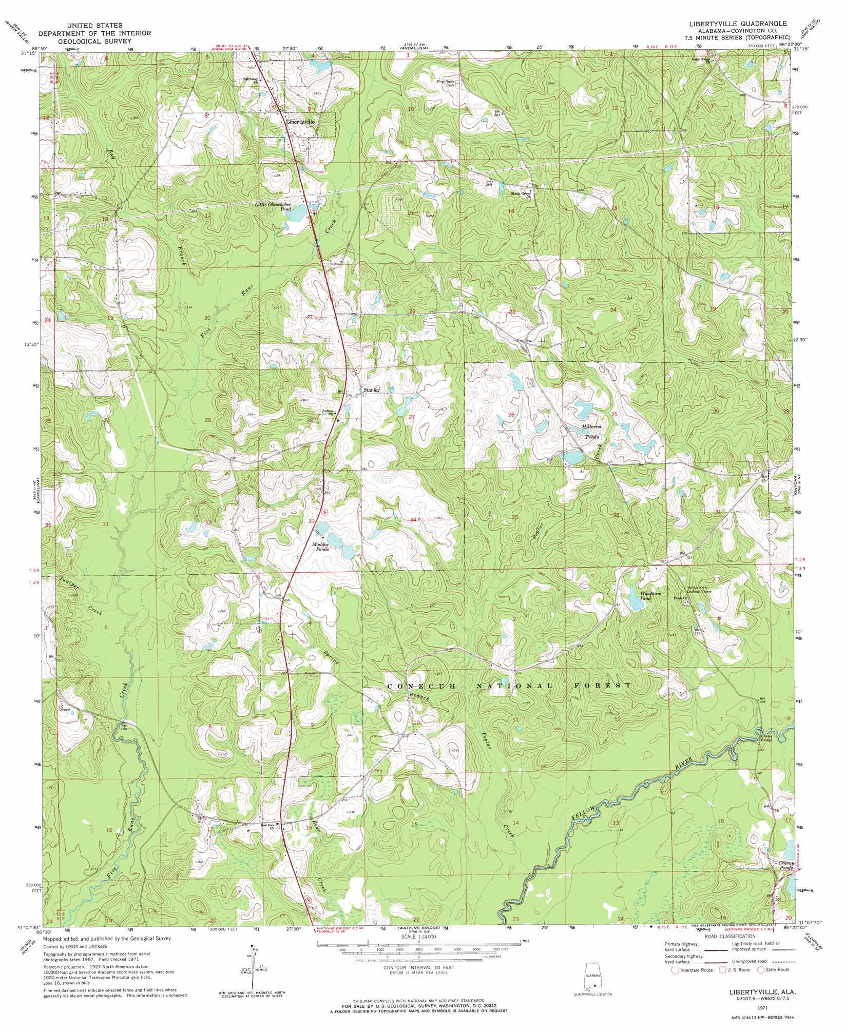
Libertyville Topo Map Alabama
To zoom in, hover over the map of Libertyville
USGS Topo Quad 31086b4 - 1:24,000 scale
| Topo Map Name: | Libertyville |
| USGS Topo Quad ID: | 31086b4 |
| Print Size: | ca. 21 1/4" wide x 27" high |
| Southeast Coordinates: | 31.125° N latitude / 86.375° W longitude |
| Map Center Coordinates: | 31.1875° N latitude / 86.4375° W longitude |
| U.S. State: | AL |
| Filename: | o31086b4.jpg |
| Download Map JPG Image: | Libertyville topo map 1:24,000 scale |
| Map Type: | Topographic |
| Topo Series: | 7.5´ |
| Map Scale: | 1:24,000 |
| Source of Map Images: | United States Geological Survey (USGS) |
| Alternate Map Versions: |
Libertyville AL 1971, updated 1973 Download PDF Buy paper map Libertyville AL 2011 Download PDF Buy paper map Libertyville AL 2014 Download PDF Buy paper map |
| FStopo: | US Forest Service topo Libertyville is available: Download FStopo PDF Download FStopo TIF |
1:24,000 Topo Quads surrounding Libertyville
Brooks |
Red Level |
Gantt |
Dozier |
Danleys Crossroads |
Loango |
River Falls |
Andalusia |
Opp West |
Opp East |
Dixie |
Carolina |
Libertyville |
Onycha |
Kinston |
Bradley |
Wing |
Watkins Bridge |
Florala |
Hacoda |
Blackman |
Oak Grove |
Laurel Hill |
Paxton |
Gaskin |
> Back to 31086a1 at 1:100,000 scale
> Back to 31086a1 at 1:250,000 scale
> Back to U.S. Topo Maps home
Libertyville topo map: Gazetteer
Libertyville: Bridges
Cravey Bridge elevation 49m 160′Libertyville: Dams
Charles Woodham Lake Dam elevation 68m 223′Clifton Maddox Dam elevation 77m 252′
Clifton Maddox Dam elevation 81m 265′
Hillcrest Pond Number 1 Dam elevation 69m 226′
Hillcrest Pond Number 2 Dam elevation 75m 246′
Libertyville: Lakes
Cravey Ponds elevation 54m 177′Libertyville: Populated Places
Libertyville elevation 82m 269′Red Oak elevation 66m 216′
Stanley elevation 87m 285′
Libertyville: Reservoirs
Hillcrest Pond elevation 69m 226′Hillcrest Pond elevation 75m 246′
Hillcrest Ponds elevation 75m 246′
Kersey Pond elevation 83m 272′
Little Okeechobee Pond elevation 62m 203′
Maddox Ponds elevation 77m 252′
Woodham Pond elevation 71m 232′
Libertyville: Streams
Bay Branch elevation 55m 180′Juniper Creek elevation 50m 164′
Poplar Creek elevation 42m 137′
Spring Branch elevation 52m 170′
Libertyville digital topo map on disk
Buy this Libertyville topo map showing relief, roads, GPS coordinates and other geographical features, as a high-resolution digital map file on DVD:
Gulf Coast (LA, MS, AL, FL) & Southwestern Georgia
Buy digital topo maps: Gulf Coast (LA, MS, AL, FL) & Southwestern Georgia
 & Southwestern Georgia map DVD")