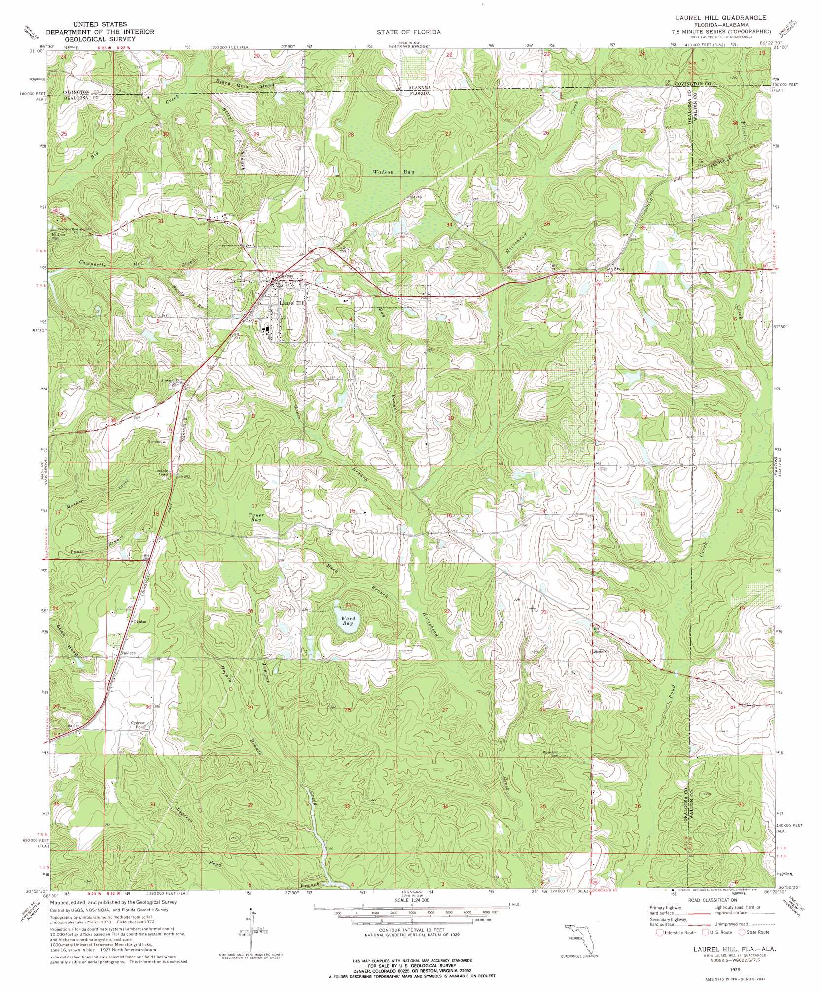
Laurel Hill Topo Map Florida
To zoom in, hover over the map of Laurel Hill
USGS Topo Quad 30086h4 - 1:24,000 scale
| Topo Map Name: | Laurel Hill |
| USGS Topo Quad ID: | 30086h4 |
| Print Size: | ca. 21 1/4" wide x 27" high |
| Southeast Coordinates: | 30.875° N latitude / 86.375° W longitude |
| Map Center Coordinates: | 30.9375° N latitude / 86.4375° W longitude |
| U.S. States: | FL, AL |
| Filename: | O30086H4.jpg |
| Download Map JPG Image: | Laurel Hill topo map 1:24,000 scale |
| Map Type: | Topographic |
| Topo Series: | 7.5´ |
| Map Scale: | 1:24,000 |
| Source of Map Images: | United States Geological Survey (USGS) |
| Alternate Map Versions: |
Laurel Hill FL 1973, updated 1975 Download PDF Buy paper map Laurel Hill FL 1973, updated 1993 Download PDF Buy paper map Laurel Hill FL 2012 Download PDF Buy paper map Laurel Hill FL 2015 Download PDF Buy paper map |
1:24,000 Topo Quads surrounding Laurel Hill
Dixie |
Carolina |
Libertyville |
Onycha |
Kinston |
Bradley |
Wing |
Watkins Bridge |
Florala |
Hacoda |
Blackman |
Oak Grove |
Laurel Hill |
Paxton |
Gaskin |
Baker |
Crestview North |
Dorcas |
New Harmony |
Liberty |
Holt |
Crestview South |
Spencer Flats |
Mossy Head |
De Funiak Springs West |
> Back to 30086e1 at 1:100,000 scale
> Back to 30086a1 at 1:250,000 scale
> Back to U.S. Topo Maps home
Laurel Hill topo map: Gazetteer
Laurel Hill: Lakes
Perry Reeves Pond elevation 74m 242′Ward Bay elevation 62m 203′
Laurel Hill: Populated Places
Laurel Hill elevation 86m 282′Okaloo elevation 83m 272′
Svea elevation 89m 291′
Laurel Hill: Reservoirs
Cypress Pond elevation 74m 242′Laurel Hill: Streams
Bandy Branch elevation 54m 177′Bay Branch elevation 55m 180′
Billys Branch elevation 48m 157′
Coon Head elevation 56m 183′
Cypress Pond Branch elevation 43m 141′
Green Branch elevation 54m 177′
Hogpen Branch elevation 46m 150′
Mack Branch elevation 50m 164′
Tyner Branch elevation 57m 187′
Laurel Hill: Swamps
Tyner Bay elevation 66m 216′Watson Bay elevation 72m 236′
Laurel Hill: Valleys
Black Gum Head elevation 47m 154′Laurel Hill digital topo map on disk
Buy this Laurel Hill topo map showing relief, roads, GPS coordinates and other geographical features, as a high-resolution digital map file on DVD:
Gulf Coast (LA, MS, AL, FL) & Southwestern Georgia
Buy digital topo maps: Gulf Coast (LA, MS, AL, FL) & Southwestern Georgia
 & Southwestern Georgia map DVD")