Elm Mott Topo Map Texas
To zoom in, hover over the map of Elm Mott
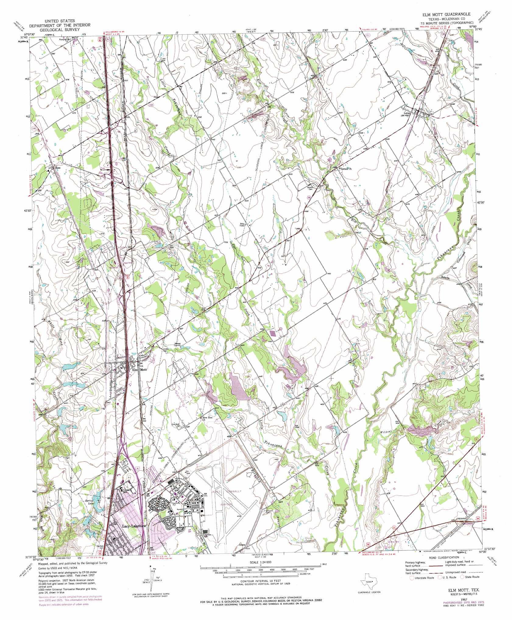
USGS Topo Quad 31097f1 - 1:24,000 scale
| Topo Map Name: | Elm Mott |
| USGS Topo Quad ID: | 31097f1 |
| Print Size: | ca. 21 1/4" wide x 27" high |
| Southeast Coordinates: | 31.625° N latitude / 97° W longitude |
| Map Center Coordinates: | 31.6875° N latitude / 97.0625° W longitude |
| U.S. State: | TX |
| Filename: | o31097f1.jpg |
| Download Map JPG Image: | Elm Mott topo map 1:24,000 scale |
| Map Type: | Topographic |
| Topo Series: | 7.5´ |
| Map Scale: | 1:24,000 |
| Source of Map Images: | United States Geological Survey (USGS) |
| Alternate Map Versions: |
Elm Mott TX 1957, updated 1958 Download PDF Buy paper map Elm Mott TX 1957, updated 1971 Download PDF Buy paper map Elm Mott TX 1957, updated 1977 Download PDF Buy paper map Elm Mott TX 2010 Download PDF Buy paper map Elm Mott TX 2013 Download PDF Buy paper map Elm Mott TX 2016 Download PDF Buy paper map |
1:24,000 Topo Quads surrounding Elm Mott
Whitney |
Peoria |
Abbott |
Malone |
Irene |
Smiths Bend |
Aquilla |
West |
Penelope |
Hubbard |
China Springs |
Gholson |
Elm Mott |
Axtell |
Prairie Hill |
Speegleville |
Waco West |
Waco East |
Elk |
Mart |
South Bosque |
Lorena |
Robinson |
Riesel |
Otto |
> Back to 31097e1 at 1:100,000 scale
> Back to 31096a1 at 1:250,000 scale
> Back to U.S. Topo Maps home
Elm Mott topo map: Gazetteer
Elm Mott: Airports
DPS Heliport elevation 151m 495′TSTC Waco Airport elevation 142m 465′
Elm Mott: Dams
Soil Conservation Service Site 14 Dam elevation 132m 433′Soil Conservation Service Site 15 Dam elevation 133m 436′
Soil Conservation Service Site 16 Dam elevation 154m 505′
Soil Conservation Service Site 17 Dam elevation 134m 439′
Soil Conservation Service Site 18 Dam elevation 139m 456′
Elm Mott: Populated Places
Elm Mott elevation 160m 524′Lacy-Lakeview elevation 148m 485′
Leroy elevation 151m 495′
Northcrest elevation 150m 492′
Ross elevation 174m 570′
Elm Mott: Reservoirs
Soil Conservation Service Site 14 Reservoir elevation 132m 433′Soil Conservation Service Site 15 Reservoir elevation 133m 436′
Soil Conservation Service Site 16 Reservoir elevation 154m 505′
Soil Conservation Service Site 17 Reservoir elevation 134m 439′
Soil Conservation Service Site 18 Reservoir elevation 139m 456′
Spring Lake elevation 140m 459′
Elm Mott: Streams
Cottonwood Creek elevation 129m 423′Elm Creek elevation 130m 426′
Little Tehuacana Creek elevation 123m 403′
Post Oak Creek elevation 131m 429′
Rice Creek elevation 134m 439′
Roberts Creek elevation 131m 429′
Wildcat Creek elevation 125m 410′
Elm Mott digital topo map on disk
Buy this Elm Mott topo map showing relief, roads, GPS coordinates and other geographical features, as a high-resolution digital map file on DVD: