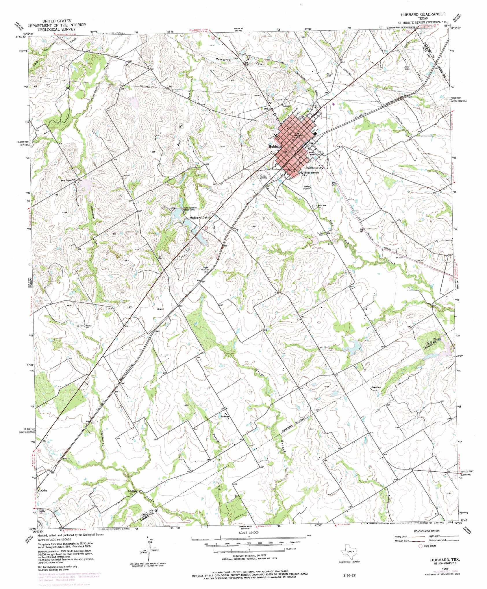
Hubbard Topo Map Texas
To zoom in, hover over the map of Hubbard
USGS Topo Quad 31096g7 - 1:24,000 scale
| Topo Map Name: | Hubbard |
| USGS Topo Quad ID: | 31096g7 |
| Print Size: | ca. 21 1/4" wide x 27" high |
| Southeast Coordinates: | 31.75° N latitude / 96.75° W longitude |
| Map Center Coordinates: | 31.8125° N latitude / 96.8125° W longitude |
| U.S. State: | TX |
| Filename: | o31096g7.jpg |
| Download Map JPG Image: | Hubbard topo map 1:24,000 scale |
| Map Type: | Topographic |
| Topo Series: | 7.5´ |
| Map Scale: | 1:24,000 |
| Source of Map Images: | United States Geological Survey (USGS) |
| Alternate Map Versions: |
Hubbard TX 1956, updated 1956 Download PDF Buy paper map Hubbard TX 1956, updated 1957 Download PDF Buy paper map Hubbard TX 1956, updated 1978 Download PDF Buy paper map Hubbard TX 2010 Download PDF Buy paper map Hubbard TX 2013 Download PDF Buy paper map Hubbard TX 2016 Download PDF Buy paper map |
1:24,000 Topo Quads surrounding Hubbard
Hillsboro East |
Mertens |
Frost |
Blooming Grove |
Corbet |
Abbott |
Malone |
Irene |
Dawson |
Purdon |
West |
Penelope |
Hubbard |
Coolidge |
Union High |
Elm Mott |
Axtell |
Prairie Hill |
Echols |
Tehuacana |
Waco East |
Elk |
Mart |
Ben Hur |
Groesbeck |
> Back to 31096e1 at 1:100,000 scale
> Back to 31096a1 at 1:250,000 scale
> Back to U.S. Topo Maps home
Hubbard topo map: Gazetteer
Hubbard: Bridges
Ruyle Bridge elevation 168m 551′Hubbard: Dams
Hubbard Lake Number 1 Dam elevation 183m 600′Hubbard Lake Number 3 Dam elevation 178m 583′
Hubbard Lake Number 4 Dam elevation 172m 564′
Hubbard Lake Number 5 Dam elevation 168m 551′
Soil Conservation Service Site 1 Dam elevation 168m 551′
Soil Conservation Service Site 2 Dam elevation 168m 551′
Soil Conservation Service Site 3 Dam elevation 165m 541′
Soil Conservation Service Site 4 Dam elevation 155m 508′
Soil Conservation Service Site 91-A Dam elevation 150m 492′
Soil Conservation Service Site 93 Dam elevation 161m 528′
Soil Conservation Service Site 94 Dam elevation 154m 505′
Hubbard: Parks
Niece Athletic Field elevation 185m 606′Hubbard: Populated Places
Hubbard elevation 198m 649′Hubbard: Reservoirs
Hubbard Lake Number 1 elevation 183m 600′Hubbard Lake Number 3 elevation 178m 583′
Hubbard Lake Number 4 elevation 172m 564′
Hubbard Lake Number 5 elevation 168m 551′
Hubbard Lakes elevation 177m 580′
Soil Conservation Service Site 1 Reservoir elevation 168m 551′
Soil Conservation Service Site 2 Reservoir elevation 168m 551′
Soil Conservation Service Site 3 Reservoir elevation 165m 541′
Soil Conservation Service Site 4 Reservoir elevation 155m 508′
Soil Conservation Service Site 91-A Reservoir elevation 150m 492′
Soil Conservation Service Site 93 Reservoir elevation 161m 528′
Soil Conservation Service Site 94 Reservoir elevation 154m 505′
Hubbard: Streams
Hackberry Creek elevation 149m 488′Hubbard digital topo map on disk
Buy this Hubbard topo map showing relief, roads, GPS coordinates and other geographical features, as a high-resolution digital map file on DVD: