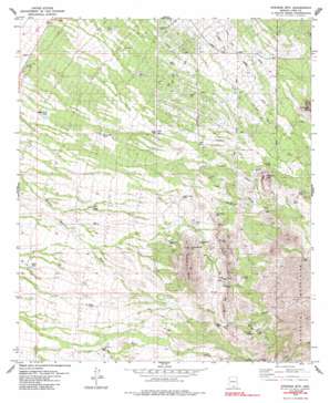
Stevens Mountain Topo Map Arizona
To zoom in, hover over the map of Stevens Mountain
USGS Topo Quad 31111h3 - 1:24,000 scale
| Topo Map Name: | Stevens Mountain |
| USGS Topo Quad ID: | 31111h3 |
| Print Size: | ca. 21 1/4" wide x 27" high |
| Southeast Coordinates: | 31.875° N latitude / 111.25° W longitude |
| Map Center Coordinates: | 31.9375° N latitude / 111.3125° W longitude |
| U.S. State: | AZ |
| Filename: | o31111h3.jpg |
| Download Map JPG Image: | Stevens Mountain topo map 1:24,000 scale |
| Map Type: | Topographic |
| Topo Series: | 7.5´ |
| Map Scale: | 1:24,000 |
| Source of Map Images: | United States Geological Survey (USGS) |
| Alternate Map Versions: |
Stevens Mtn. AZ 1979, updated 1979 Download PDF Buy paper map Stevens Mtn. AZ 1979, updated 1985 Download PDF Buy paper map Stevens Mountain AZ 2011 Download PDF Buy paper map Stevens Mountain AZ 2014 Download PDF Buy paper map |
1:24,000 Topo Quads surrounding Stevens Mountain
> Back to 31111e1 at 1:100,000 scale
> Back to 31110a1 at 1:250,000 scale
> Back to U.S. Topo Maps home
Stevens Mountain topo map: Gazetteer
Stevens Mountain: Mines
Aguinaldo Mine elevation 1139m 3736′Banner Mine elevation 1162m 3812′
Black Dike Mine elevation 1113m 3651′
Clark Mine elevation 1152m 3779′
Copper Glance Mine elevation 1056m 3464′
Gold Hill Mine elevation 1222m 4009′
Little Johnny Mine elevation 1103m 3618′
Montezuma Mine elevation 1133m 3717′
Philimena Mine elevation 1044m 3425′
Sunshine Mine elevation 1273m 4176′
Yellow Bird Mine elevation 1094m 3589′
Stevens Mountain: Populated Places
Diamond Bell Ranch elevation 1058m 3471′Stevens Mountain: Reservoirs
Calera Tank elevation 960m 3149′Garambolo Tank elevation 947m 3106′
Hall Tank elevation 1054m 3458′
La Cholla Tank elevation 990m 3248′
Rodeo Tank elevation 918m 3011′
Soldier Well Tank elevation 891m 2923′
Tank Number Four elevation 948m 3110′
Tank Number Thirtytwo elevation 895m 2936′
Tank Number Thirty-two elevation 899m 2949′
Valencia Tank elevation 1135m 3723′
Stevens Mountain: Streams
Ash Creek elevation 1173m 3848′Stevens Mountain: Summits
Iron Mountain elevation 1470m 4822′Providencia Hill elevation 1217m 3992′
Stevens Mountain elevation 1343m 4406′
Valencia Mountain elevation 1260m 4133′
Stevens Mountain: Wells
Aguajita Well elevation 1198m 3930′Mollen Well elevation 1004m 3293′
Stevens Mountain digital topo map on disk
Buy this Stevens Mountain topo map showing relief, roads, GPS coordinates and other geographical features, as a high-resolution digital map file on DVD:


