Twin Buttes Topo Map Arizona
To zoom in, hover over the map of Twin Buttes
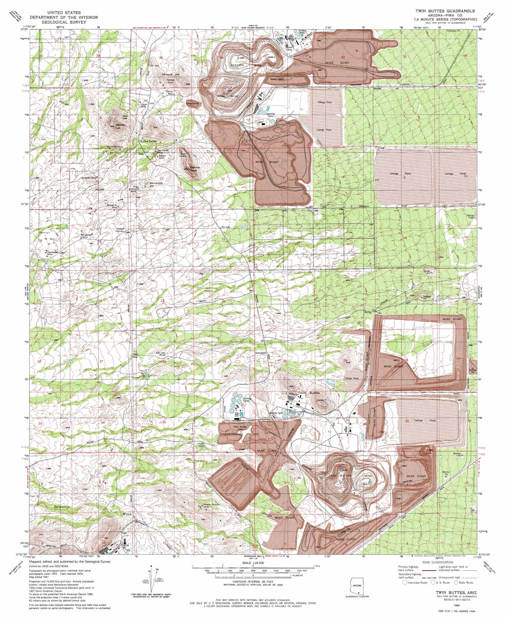
USGS Topo Quad 31111h1 - 1:24,000 scale
| Topo Map Name: | Twin Buttes |
| USGS Topo Quad ID: | 31111h1 |
| Print Size: | ca. 21 1/4" wide x 27" high |
| Southeast Coordinates: | 31.875° N latitude / 111° W longitude |
| Map Center Coordinates: | 31.9375° N latitude / 111.0625° W longitude |
| U.S. State: | AZ |
| Filename: | o31111h1.jpg |
| Download Map JPG Image: | Twin Buttes topo map 1:24,000 scale |
| Map Type: | Topographic |
| Topo Series: | 7.5´ |
| Map Scale: | 1:24,000 |
| Source of Map Images: | United States Geological Survey (USGS) |
| Alternate Map Versions: |
Twin Buttes AZ 1981, updated 1981 Download PDF Buy paper map Twin Buttes AZ 1981, updated 1981 Download PDF Buy paper map Twin Buttes AZ 2011 Download PDF Buy paper map Twin Buttes AZ 2014 Download PDF Buy paper map |
1:24,000 Topo Quads surrounding Twin Buttes
Cocoraque Butte |
Brown Mountain |
Cat Mountain |
Tucson |
Tucson East |
Three Points |
San Xavier Mission Sw |
San Xavier Mission |
Tucson Sw |
Tucson Se |
Stevens Mountain |
Samaniego Peak |
Twin Buttes |
Sahuarita |
Corona De Tucson |
Penitas Hills |
Batamote Hills |
Esperanza Mill |
Green Valley |
Helvetia |
Cerro Colorado |
Saucito Mountain |
Amado |
Mount Hopkins |
Mount Wrightson |
> Back to 31111e1 at 1:100,000 scale
> Back to 31110a1 at 1:250,000 scale
> Back to U.S. Topo Maps home
Twin Buttes topo map: Gazetteer
Twin Buttes: Arroyos
Angelica Wash elevation 1031m 3382′Marjorie Wash elevation 1049m 3441′
Rodolfo Wash elevation 1037m 3402′
Twin Buttes: Dams
Esperanza Tailings Dam elevation 884m 2900′Mission Tailings Dam Number One elevation 884m 2900′
Missions Tailings Dam Number Two elevation 884m 2900′
Twin Buttes Tailings Dam elevation 989m 3244′
Twin Buttes: Mines
Banner Mine elevation 1031m 3382′Bobbie Mine elevation 1071m 3513′
Dogtown Mine elevation 1136m 3727′
Mineral Hill Mine elevation 1063m 3487′
Mission Mine elevation 829m 2719′
Olivette Mine elevation 1103m 3618′
Paymaster Mine elevation 1167m 3828′
Pima Mine elevation 999m 3277′
Prosperity Mine elevation 1111m 3645′
San Xavier Mine elevation 1073m 3520′
Senator Morgan Mine elevation 1101m 3612′
Swastika Mine elevation 1120m 3674′
Twin Buttes Mine elevation 843m 2765′
University Mine elevation 1091m 3579′
Vulcan Mine elevation 1064m 3490′
Twin Buttes: Populated Places
San Xavier elevation 1079m 3540′Twin Buttes elevation 1067m 3500′
Twin Buttes: Summits
Helmet Peak elevation 1168m 3832′Indian Kitchen elevation 1116m 3661′
Mineral Hill elevation 1072m 3517′
Twin Buttes elevation 1130m 3707′
Whitcomb Hill elevation 1104m 3622′
White Hill elevation 1212m 3976′
Twin Buttes digital topo map on disk
Buy this Twin Buttes topo map showing relief, roads, GPS coordinates and other geographical features, as a high-resolution digital map file on DVD: