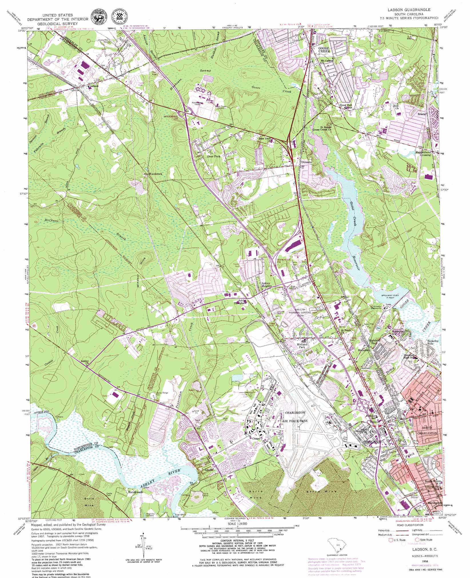
Ladson Topo Map South Carolina
To zoom in, hover over the map of Ladson
USGS Topo Quad 32080h1 - 1:24,000 scale
| Topo Map Name: | Ladson |
| USGS Topo Quad ID: | 32080h1 |
| Print Size: | ca. 21 1/4" wide x 27" high |
| Southeast Coordinates: | 32.875° N latitude / 80° W longitude |
| Map Center Coordinates: | 32.9375° N latitude / 80.0625° W longitude |
| U.S. State: | SC |
| Filename: | o32080h1.jpg |
| Download Map JPG Image: | Ladson topo map 1:24,000 scale |
| Map Type: | Topographic |
| Topo Series: | 7.5´ |
| Map Scale: | 1:24,000 |
| Source of Map Images: | United States Geological Survey (USGS) |
| Alternate Map Versions: |
Ladson SC 1943 Download PDF Buy paper map Ladson SC 1943 Download PDF Buy paper map Ladson SC 1958, updated 1959 Download PDF Buy paper map Ladson SC 1958, updated 1973 Download PDF Buy paper map Ladson SC 1958, updated 1980 Download PDF Buy paper map Ladson SC 1958, updated 1980 Download PDF Buy paper map Ladson SC 2011 Download PDF Buy paper map Ladson SC 2014 Download PDF Buy paper map |
1:24,000 Topo Quads surrounding Ladson
Pringletown |
Summerville Nw |
Moncks Corner |
Cordesville |
Bethera |
Ridgeville |
Summerville |
Mount Holly |
Kittredge |
Huger |
Clubhouse Crossroads |
Stallsville |
Ladson |
North Charleston |
Cainhoy |
Osborn |
Ravenel |
Johns Island |
Charleston |
Fort Moultrie |
Adams Run |
Wadmalaw Island |
Legareville |
James Island |
> Back to 32080e1 at 1:100,000 scale
> Back to 32080a1 at 1:250,000 scale
> Back to U.S. Topo Maps home
Ladson topo map: Gazetteer
Ladson: Airports
Charleston International Airport elevation 16m 52′Ladson: Crossings
Interchange 205 elevation 15m 49′Interchange 208 elevation 10m 32′
Interchange 209 elevation 15m 49′
Interchange 211 elevation 16m 52′
Ladson: Parks
Hillsdale Park elevation 13m 42′Midland Park elevation 17m 55′
Ladson: Populated Places
Ararat elevation 11m 36′Archdale elevation 11m 36′
Ashley Heights elevation 13m 42′
Belvedere elevation 11m 36′
Berkeley Hills elevation 10m 32′
Camelot Village elevation 16m 52′
Colony North elevation 11m 36′
Deer Park elevation 18m 59′
Deerwood Heights elevation 14m 45′
Dorchester Manor elevation 12m 39′
Ferndale elevation 11m 36′
Forest Hills elevation 14m 45′
Forestdale elevation 13m 42′
Goose Creek elevation 14m 45′
Goose Creek Heights elevation 12m 39′
Hanahan elevation 16m 52′
Harbour Lake elevation 13m 42′
Highland Park elevation 16m 52′
Highland Terrace elevation 12m 39′
Highlands elevation 16m 52′
Hunley Park elevation 15m 49′
Ladson elevation 15m 49′
Ladson Village elevation 15m 49′
Lambs elevation 12m 39′
Liberty Hills elevation 10m 32′
Liberty Park elevation 14m 45′
Maple Ridge elevation 12m 39′
Midland Park elevation 18m 59′
Northwood Estates elevation 12m 39′
Oak Grove elevation 19m 62′
Otranto elevation 11m 36′
Pepperhill elevation 12m 39′
Pepperidge elevation 11m 36′
Pineview Hills elevation 16m 52′
Pinewood Vista elevation 18m 59′
Pleasant Hills elevation 17m 55′
Poppenheim Crossing elevation 10m 32′
Riverbend elevation 13m 42′
Runnymede elevation 6m 19′
Russelldale elevation 9m 29′
Saint James Estates elevation 12m 39′
Sedgefield elevation 15m 49′
Shady Grove elevation 9m 29′
Singing Pines elevation 17m 55′
Stratton Capers elevation 12m 39′
Tenmile elevation 18m 59′
The Farms elevation 16m 52′
The Oaks elevation 14m 45′
University Park elevation 12m 39′
West Greenview Acres elevation 13m 42′
Wildwood elevation 15m 49′
Willowbrook elevation 10m 32′
Wilsonville elevation 17m 55′
Woodstock elevation 11m 36′
Ladson: Post Offices
Charleston Air Force Base Post Office elevation 17m 55′Cross County Branch Post Office elevation 11m 36′
Goose Creek Post Office elevation 14m 45′
Ladson Post Office elevation 16m 52′
North Charleston Post Office elevation 15m 49′
Ladson: Reservoirs
Goose Creek Reservoir elevation 2m 6′Ladson: Streams
Federwitz Branch elevation 9m 29′McChune Branch elevation 9m 29′
Olive Branch elevation 0m 0′
Popperdam Creek elevation 0m 0′
Sawpit Creek elevation 0m 0′
Spencer Branch elevation 9m 29′
Turkey Creek elevation 1m 3′
Ladson: Summits
Windsor Hills elevation 11m 36′Ladson: Swamps
Bluehouse Swamp elevation 5m 16′Ladson digital topo map on disk
Buy this Ladson topo map showing relief, roads, GPS coordinates and other geographical features, as a high-resolution digital map file on DVD:
South Carolina, Western North Carolina & Northeastern Georgia
Buy digital topo maps: South Carolina, Western North Carolina & Northeastern Georgia