Huger Topo Map South Carolina
To zoom in, hover over the map of Huger
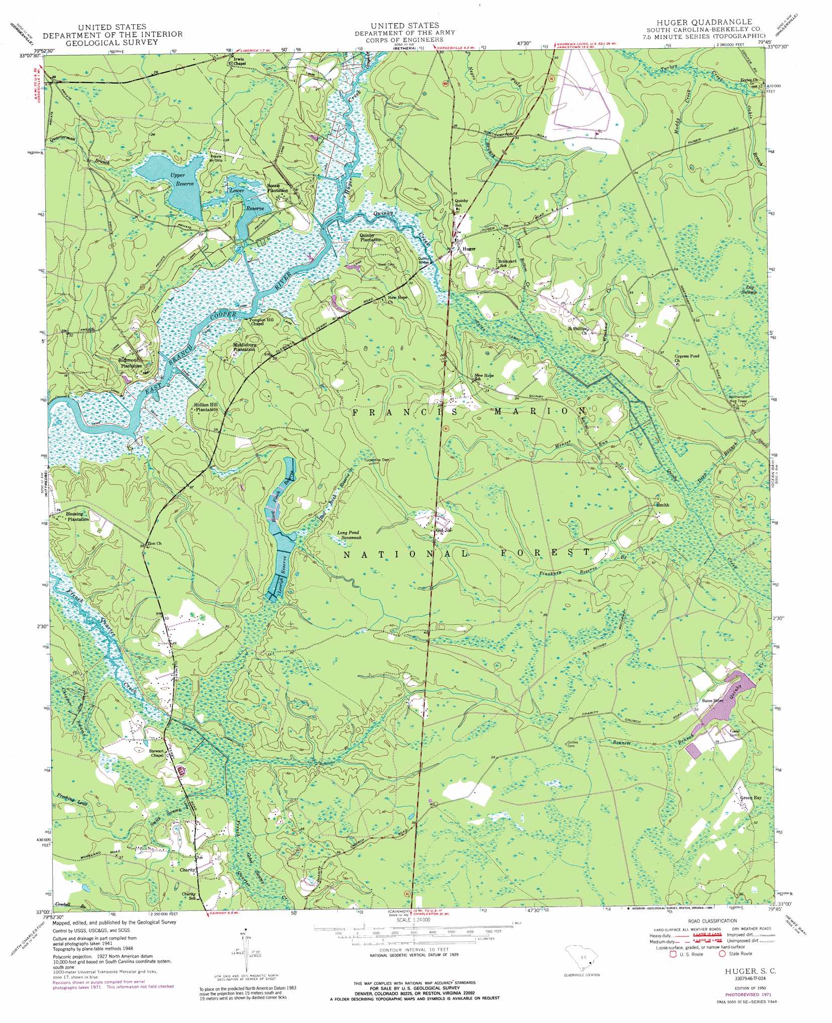
USGS Topo Quad 33079a7 - 1:24,000 scale
| Topo Map Name: | Huger |
| USGS Topo Quad ID: | 33079a7 |
| Print Size: | ca. 21 1/4" wide x 27" high |
| Southeast Coordinates: | 33° N latitude / 79.75° W longitude |
| Map Center Coordinates: | 33.0625° N latitude / 79.8125° W longitude |
| U.S. State: | SC |
| Filename: | o33079a7.jpg |
| Download Map JPG Image: | Huger topo map 1:24,000 scale |
| Map Type: | Topographic |
| Topo Series: | 7.5´ |
| Map Scale: | 1:24,000 |
| Source of Map Images: | United States Geological Survey (USGS) |
| Alternate Map Versions: |
Huger SC 1950 Download PDF Buy paper map Huger SC 1950 Download PDF Buy paper map Huger SC 1950, updated 1973 Download PDF Buy paper map Huger SC 1950, updated 1989 Download PDF Buy paper map Huger SC 2011 Download PDF Buy paper map Huger SC 2014 Download PDF Buy paper map |
| FStopo: | US Forest Service topo Huger is available: Download FStopo PDF Download FStopo TIF |
1:24,000 Topo Quads surrounding Huger
Chicora |
Bonneau |
Wedboo Creek |
Jamestown |
Cedar Creek |
Moncks Corner |
Cordesville |
Bethera |
Shulerville |
Honey Hill |
Mount Holly |
Kittredge |
Huger |
Ocean Bay |
Awendaw |
Ladson |
North Charleston |
Cainhoy |
Sewee Bay |
Bull Island |
Johns Island |
Charleston |
Fort Moultrie |
Capers Inlet |
> Back to 33079a1 at 1:100,000 scale
> Back to 33078a1 at 1:250,000 scale
> Back to U.S. Topo Maps home
Huger topo map: Gazetteer
Huger: Bridges
Quinby Bridge elevation 1m 3′Huger: Canals
Hester Canal elevation 2m 6′Huger: Dams
South Carolina Noname 08001 D-3473 Dam elevation 7m 22′South Carolina Noname 08025 D-3472 Dam elevation 4m 13′
Turpentine Dam elevation 9m 29′
Huger: Populated Places
Charity elevation 7m 22′Green Bay elevation 9m 29′
Huger elevation 9m 29′
New Hope elevation 6m 19′
Old Joe elevation 9m 29′
Red Hill elevation 7m 22′
Smith elevation 8m 26′
Spring Hill (historical) elevation 9m 29′
Huger: Reservoirs
Bates Pond elevation 7m 22′Hard Pinch Reserve elevation 4m 13′
Leneigh Reserve elevation 4m 13′
Lower Reserve elevation 1m 3′
Red Bank Reserve elevation 6m 19′
Upper Reserve elevation 2m 6′
Upper Reserve Pond elevation 4m 13′
Huger: Streams
Deep Branch elevation 3m 9′Gough Creek elevation 1m 3′
Huger Creek elevation 1m 3′
Menzer Run elevation 3m 9′
Muddy Creek elevation 5m 16′
Pinckney Reserve Branch elevation 5m 16′
Quarterman Branch elevation 1m 3′
Quimby Creek elevation 1m 3′
Washaw Creek elevation 3m 9′
York Bottom Creek elevation 2m 6′
Huger: Swamps
Chipper Swamp elevation 4m 13′Gobel Swamp elevation 2m 6′
Long Pond Savannah elevation 11m 36′
Smith Swamp elevation 5m 16′
Huger digital topo map on disk
Buy this Huger topo map showing relief, roads, GPS coordinates and other geographical features, as a high-resolution digital map file on DVD:
South Carolina, Western North Carolina & Northeastern Georgia
Buy digital topo maps: South Carolina, Western North Carolina & Northeastern Georgia