Berryville Topo Map Mississippi
To zoom in, hover over the map of Berryville
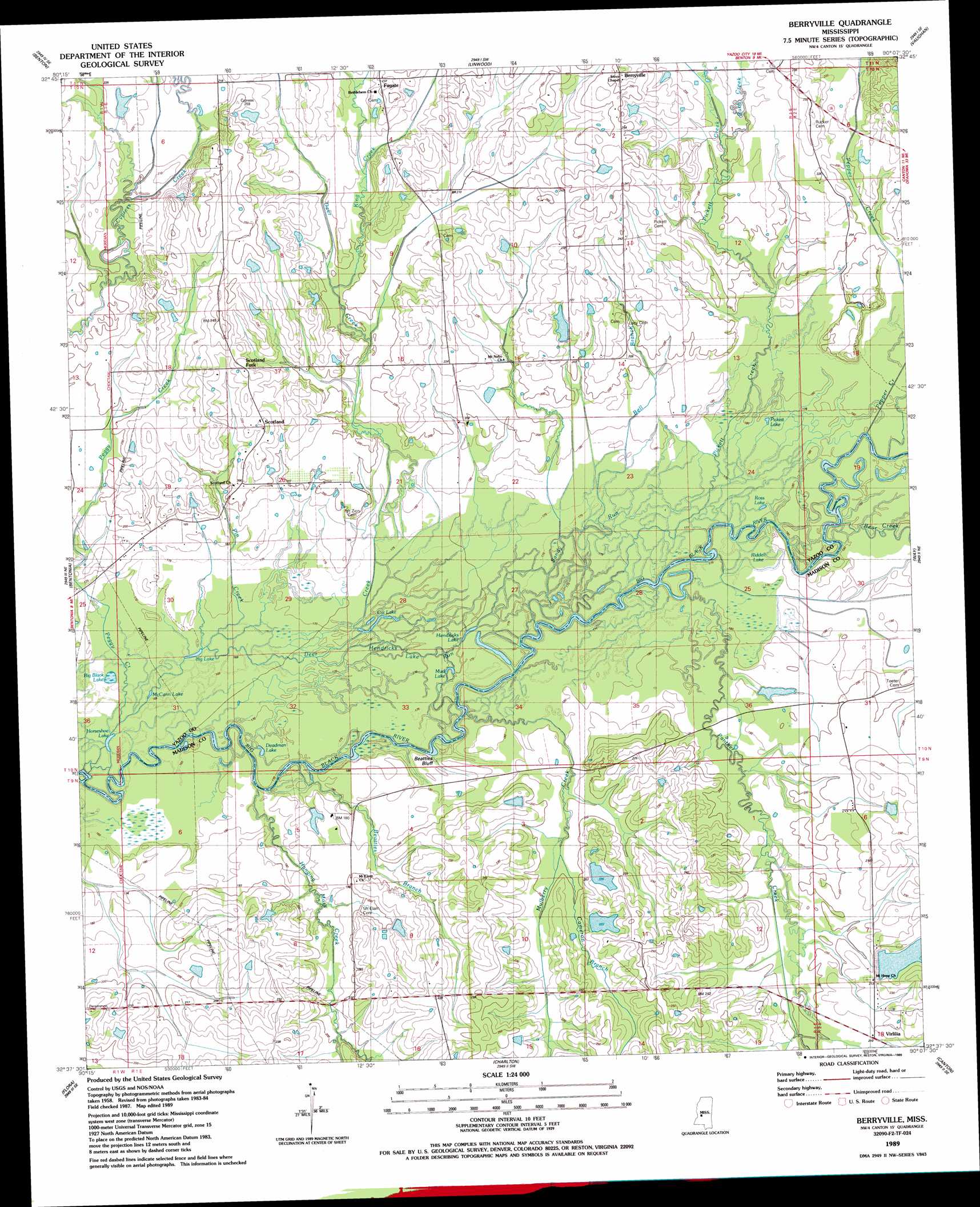
USGS Topo Quad 32090f2 - 1:24,000 scale
| Topo Map Name: | Berryville |
| USGS Topo Quad ID: | 32090f2 |
| Print Size: | ca. 21 1/4" wide x 27" high |
| Southeast Coordinates: | 32.625° N latitude / 90.125° W longitude |
| Map Center Coordinates: | 32.6875° N latitude / 90.1875° W longitude |
| U.S. State: | MS |
| Filename: | o32090f2.jpg |
| Download Map JPG Image: | Berryville topo map 1:24,000 scale |
| Map Type: | Topographic |
| Topo Series: | 7.5´ |
| Map Scale: | 1:24,000 |
| Source of Map Images: | United States Geological Survey (USGS) |
| Alternate Map Versions: |
Berryville MS 1989, updated 1989 Download PDF Buy paper map Berryville MS 2012 Download PDF Buy paper map Berryville MS 2015 Download PDF Buy paper map |
1:24,000 Topo Quads surrounding Berryville
Carter |
Eden |
Zeiglerville |
Ebenezer |
Goodman |
Yazoo City |
Benton |
Linwood |
Vaughan |
Cameron |
Tinsley |
Bentonia |
Berryville |
Way |
Sharon |
Coxs Ferry |
Flora |
Charlton |
Canton |
Shoccoe |
Brownsville |
Pocahontas |
Ridgeland |
Madison |
Goshen Springs |
> Back to 32090e1 at 1:100,000 scale
> Back to 32090a1 at 1:250,000 scale
> Back to U.S. Topo Maps home
Berryville topo map: Gazetteer
Berryville: Cliffs
Beatties Bluff elevation 50m 164′Berryville: Dams
C G Thomas Lake Dam elevation 67m 219′Jay B Pepper Pond Dam elevation 64m 209′
Pepper Lake Dam elevation 65m 213′
T Bar P Lake Dam elevation 54m 177′
T Bar P Lake Dam elevation 70m 229′
Berryville: Lakes
Big Black Lake elevation 50m 164′Big Lake elevation 50m 164′
Cat Lake elevation 52m 170′
Deadman Lake elevation 51m 167′
Hendricks Lake elevation 51m 167′
Horseshoe Lake elevation 49m 160′
McCann Lake elevation 50m 164′
Mud Lake elevation 51m 167′
Pickett Lake elevation 54m 177′
Riddell Lake elevation 54m 177′
Ross Lake elevation 52m 170′
Berryville: Populated Places
Berryville elevation 72m 236′Fugate elevation 72m 236′
Scotland elevation 70m 229′
Scotland Fork elevation 73m 239′
Virlilia elevation 64m 209′
Berryville: Post Offices
Beaties Bluff Post Office (historical) elevation 56m 183′Berryville: Streams
Bear Creek elevation 55m 180′Beatties Branch elevation 51m 167′
Bell Branch elevation 53m 173′
Burg Creek elevation 60m 196′
Cameron Branch elevation 58m 190′
Deer Creek elevation 50m 164′
Hanging Moss Creek elevation 51m 167′
Hendricks Lake Run elevation 51m 167′
King Creek elevation 62m 203′
Mulberry Creek elevation 51m 167′
Panther Creek elevation 52m 170′
Peggy Creek elevation 50m 164′
Pepper Creek elevation 55m 180′
Pickett Creek elevation 53m 173′
Pin Creek elevation 50m 164′
Rucker Creek elevation 61m 200′
Sandy Run elevation 52m 170′
Berryville digital topo map on disk
Buy this Berryville topo map showing relief, roads, GPS coordinates and other geographical features, as a high-resolution digital map file on DVD: