Circle Mesa Topo Map New Mexico
To zoom in, hover over the map of Circle Mesa
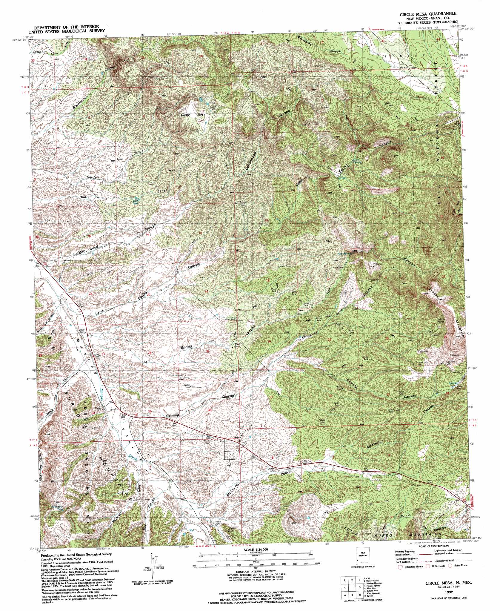
USGS Topo Quad 32108g4 - 1:24,000 scale
| Topo Map Name: | Circle Mesa |
| USGS Topo Quad ID: | 32108g4 |
| Print Size: | ca. 21 1/4" wide x 27" high |
| Southeast Coordinates: | 32.75° N latitude / 108.375° W longitude |
| Map Center Coordinates: | 32.8125° N latitude / 108.4375° W longitude |
| U.S. State: | NM |
| Filename: | o32108g4.jpg |
| Download Map JPG Image: | Circle Mesa topo map 1:24,000 scale |
| Map Type: | Topographic |
| Topo Series: | 7.5´ |
| Map Scale: | 1:24,000 |
| Source of Map Images: | United States Geological Survey (USGS) |
| Alternate Map Versions: |
Circle Mesa NM 1949, updated 1966 Download PDF Buy paper map Circle Mesa NM 1949, updated 1971 Download PDF Buy paper map Circle Mesa NM 1951 Download PDF Buy paper map Circle Mesa NM 1992, updated 1992 Download PDF Buy paper map Circle Mesa NM 2011 Download PDF Buy paper map Circle Mesa NM 2013 Download PDF Buy paper map Circle Mesa NM 2017 Download PDF Buy paper map |
| FStopo: | US Forest Service topo Circle Mesa is available: Download FStopo PDF Download FStopo TIF |
1:24,000 Topo Quads surrounding Circle Mesa
Buckhorn |
Canteen Canyon |
Canyon Hill |
Granny Mountain |
Copperas Peak |
Antelope Ridge |
Cliff |
Dorsey Ranch |
Reading Mountain |
Twin Sisters |
Brushy Mountain |
Mangas Springs |
Circle Mesa |
Silver City |
Fort Bayard |
Redrock |
Bullard Peak |
Wind Mountain |
Tyrone |
Hurley West |
Willow Draw |
Eagle Eye Peak |
Burro Peak |
White Signal |
Whitewater |
> Back to 32108e1 at 1:100,000 scale
> Back to 32108a1 at 1:250,000 scale
> Back to U.S. Topo Maps home
Circle Mesa topo map: Gazetteer
Circle Mesa: Mines
Alice Mine elevation 1840m 6036′Dorsey Mine elevation 1852m 6076′
New England elevation 1818m 5964′
Old Man Mine elevation 1879m 6164′
Old Woman Mine elevation 1846m 6056′
Pauline Mine elevation 2107m 6912′
Wake-Up-Charlie Mine elevation 1589m 5213′
Circle Mesa: Reservoirs
Agua Alto Tank elevation 1663m 5456′Dud Tank elevation 1556m 5104′
Circle Mesa: Springs
Ash Spring elevation 1746m 5728′Cane Spring elevation 1731m 5679′
Circle Mesa: Summits
Circle Mesa elevation 1780m 5839′Treasure Mountain elevation 2129m 6984′
Circle Mesa: Valleys
Alies Seep Canyon elevation 1644m 5393′Ash Spring Canyon elevation 1501m 4924′
Barney Kerr Canyon elevation 1486m 4875′
Box Canyon elevation 1532m 5026′
Cane Spring Canyon elevation 1496m 4908′
Cottonwood Canyon elevation 1480m 4855′
Fleming Canyon elevation 1517m 4977′
Haystack Canyon elevation 1522m 4993′
McKeefer Canyon elevation 1540m 5052′
Saddle Rock Canyon elevation 1503m 4931′
Circle Mesa: Wells
Franks 5 Water Well elevation 1781m 5843′Circle Mesa digital topo map on disk
Buy this Circle Mesa topo map showing relief, roads, GPS coordinates and other geographical features, as a high-resolution digital map file on DVD: