Mcbean Topo Map Georgia
To zoom in, hover over the map of Mcbean
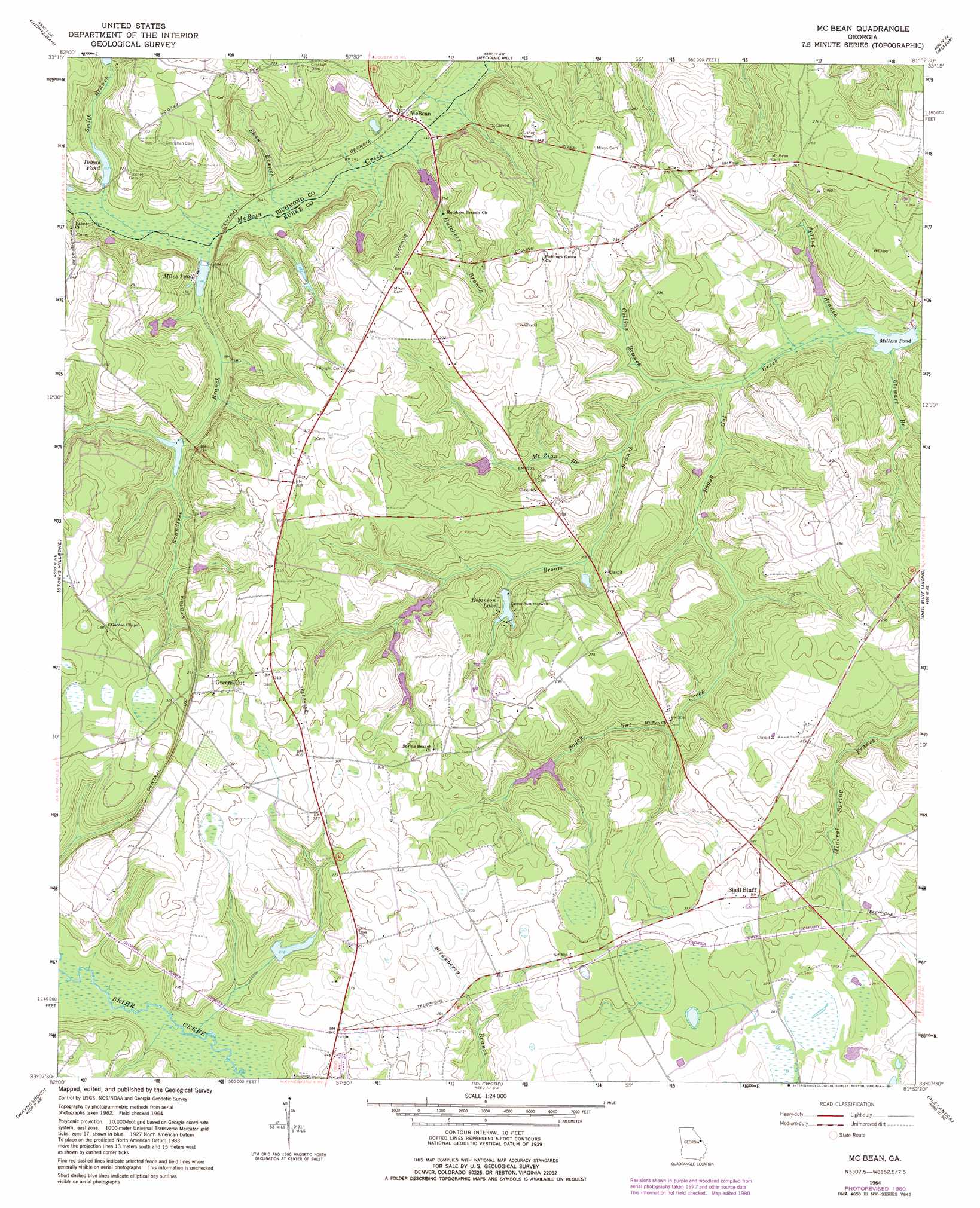
USGS Topo Quad 33081b8 - 1:24,000 scale
| Topo Map Name: | Mcbean |
| USGS Topo Quad ID: | 33081b8 |
| Print Size: | ca. 21 1/4" wide x 27" high |
| Southeast Coordinates: | 33.125° N latitude / 81.875° W longitude |
| Map Center Coordinates: | 33.1875° N latitude / 81.9375° W longitude |
| U.S. State: | GA |
| Filename: | o33081b8.jpg |
| Download Map JPG Image: | Mcbean topo map 1:24,000 scale |
| Map Type: | Topographic |
| Topo Series: | 7.5´ |
| Map Scale: | 1:24,000 |
| Source of Map Images: | United States Geological Survey (USGS) |
| Alternate Map Versions: |
Mc Bean GA 1964, updated 1965 Download PDF Buy paper map Mc Bean GA 1964, updated 1981 Download PDF Buy paper map McBean GA 2011 Download PDF Buy paper map McBean GA 2014 Download PDF Buy paper map |
1:24,000 Topo Quads surrounding Mcbean
Grovetown |
Augusta West |
Augusta East |
Hollow Creek |
New Ellenton |
Blythe |
Hephzibah |
Mechanic Hill |
Jackson |
New Ellenton Sw |
Keysville |
Storys Millpond |
Mcbean |
Shell Bluff Landing |
Girard Nw |
Gough |
Waynesboro |
Idlewood |
Alexander |
Girard |
Scotts Corner |
Bellevue |
Perkins |
Sardis |
Hilltonia |
> Back to 33081a1 at 1:100,000 scale
> Back to 33080a1 at 1:250,000 scale
> Back to U.S. Topo Maps home
Mcbean topo map: Gazetteer
Mcbean: Dams
Boyd Lake Dam elevation 57m 187′Crockett Lake Dam elevation 66m 216′
Fryhofer Lake Dam elevation 68m 223′
Hagler Lake Dam elevation 62m 203′
Millers Pond Dam elevation 35m 114′
Robinson Lake Dam elevation 56m 183′
Smith Branch Pond Dam elevation 54m 177′
Southland Timber Lake Dam elevation 44m 144′
Mcbean: Populated Places
McBean elevation 41m 134′Shell Bluff elevation 98m 321′
Mcbean: Reservoirs
Boyd Lake elevation 57m 187′Crockett Lake elevation 66m 216′
Dorns Pond elevation 48m 157′
Fryhofer Lake elevation 68m 223′
Hagler Lake elevation 62m 203′
Miles Pond elevation 42m 137′
Millers Pond elevation 35m 114′
Robinson Lake elevation 56m 183′
Smith Branch Pond elevation 54m 177′
Southland Timber Lake elevation 44m 144′
Watkins Pond elevation 52m 170′
Mcbean: Streams
Broom Branch elevation 38m 124′Collins Branch elevation 39m 127′
Hatchers Branch elevation 37m 121′
Mount Zion Branch elevation 42m 137′
Roundtree Branch elevation 42m 137′
Shaw Branch elevation 39m 127′
Smith Branch elevation 42m 137′
Spring Branch elevation 35m 114′
Stewart Branch elevation 35m 114′
Mcbean digital topo map on disk
Buy this Mcbean topo map showing relief, roads, GPS coordinates and other geographical features, as a high-resolution digital map file on DVD:
South Carolina, Western North Carolina & Northeastern Georgia
Buy digital topo maps: South Carolina, Western North Carolina & Northeastern Georgia