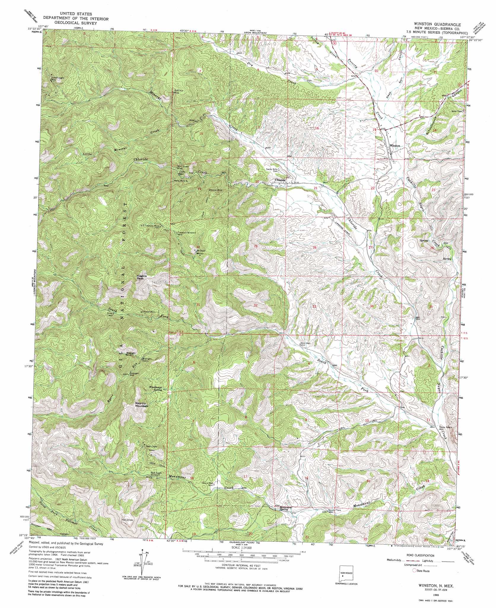
Winston Topo Map New Mexico
To zoom in, hover over the map of Winston
USGS Topo Quad 33107c6 - 1:24,000 scale
| Topo Map Name: | Winston |
| USGS Topo Quad ID: | 33107c6 |
| Print Size: | ca. 21 1/4" wide x 27" high |
| Southeast Coordinates: | 33.25° N latitude / 107.625° W longitude |
| Map Center Coordinates: | 33.3125° N latitude / 107.6875° W longitude |
| U.S. State: | NM |
| Filename: | o33107c6.jpg |
| Download Map JPG Image: | Winston topo map 1:24,000 scale |
| Map Type: | Topographic |
| Topo Series: | 7.5´ |
| Map Scale: | 1:24,000 |
| Source of Map Images: | United States Geological Survey (USGS) |
| Alternate Map Versions: |
Winston NM 1965, updated 1967 Download PDF Buy paper map Winston NM 1965, updated 1986 Download PDF Buy paper map Winston NM 1999, updated 2002 Download PDF Buy paper map Winston NM 2011 Download PDF Buy paper map Winston NM 2013 Download PDF Buy paper map Winston NM 2017 Download PDF Buy paper map |
| FStopo: | US Forest Service topo Winston is available: Download FStopo PDF Download FStopo TIF |
1:24,000 Topo Quads surrounding Winston
Indian Peaks East |
Wahoo Peak |
Wahoo Ranch |
Montoya Butte |
Vicks Peak |
Taylor Peak |
Sawmill Peak |
Iron Mountain |
Jaralosa Mountain |
Monticello |
Baily Points |
Lookout Mountain |
Winston |
Chise |
Priest Tank |
Bonner Canyon |
Reeds Peak |
Sugarloaf Peak |
Thumb Tank Peak |
Williamsburg Nw |
Hay Mesa |
Victoria Park |
Apache Peak |
Bell Mountain |
Saladone Tank |
> Back to 33107a1 at 1:100,000 scale
> Back to 33106a1 at 1:250,000 scale
> Back to U.S. Topo Maps home
Winston topo map: Gazetteer
Winston: Mines
Bald Eagle Mines elevation 2106m 6909′Colossal and Midnight Mines elevation 1995m 6545′
Colossal Mine elevation 1986m 6515′
Dreadnaught elevation 2152m 7060′
Dreadnaught Mine elevation 2176m 7139′
Gold Hill elevation 2076m 6811′
Gold Hill Mine elevation 2089m 6853′
Green Fly Mine elevation 2099m 6886′
Hoosier Mine elevation 2094m 6870′
Little Joe Mine elevation 2099m 6886′
Midnight Mine elevation 2021m 6630′
Nana elevation 1975m 6479′
Nana Mine elevation 1962m 6437′
Northern Light Mine elevation 2099m 6886′
Pye Lode elevation 2244m 7362′
Saint Cloud Mines elevation 2065m 6774′
U.S. Treasury elevation 2153m 7063′
United States Treasury Mine elevation 2160m 7086′
Wall Street Mine elevation 1961m 6433′
White Mountain Group elevation 2014m 6607′
Winston: Populated Places
Chloride elevation 1884m 6181′Winston elevation 1877m 6158′
Winston: Post Offices
Chloride Post Office (historical) elevation 1884m 6181′Winston Post Office elevation 1877m 6158′
Winston: Springs
Monument Spring elevation 1884m 6181′Woodhouse Spring elevation 1975m 6479′
Winston: Streams
Byers Run elevation 1889m 6197′Chloride Creek elevation 1795m 5889′
Dry Creek elevation 1900m 6233′
Little Mineral Creek elevation 1967m 6453′
Mineral Creek elevation 1855m 6085′
Poverty Creek elevation 1878m 6161′
South Fork Cuchillo Negro Creek elevation 1782m 5846′
Turkey Creek elevation 1904m 6246′
Winston: Summits
Hagins Peak elevation 2356m 7729′Way-Up Mountain elevation 2236m 7335′
Winston: Valleys
Deep Well Canyon elevation 1889m 6197′Pinatosa Canyon elevation 1824m 5984′
Schoolhouse Canyon elevation 1878m 6161′
Winston: Wells
Garcia Well elevation 1936m 6351′Lucky Well elevation 1954m 6410′
Midnight Well elevation 1968m 6456′
Silver Well elevation 1963m 6440′
Square Tank Well elevation 1854m 6082′
Stone Ranch Well elevation 1784m 5853′
West Well elevation 1846m 6056′
Winston digital topo map on disk
Buy this Winston topo map showing relief, roads, GPS coordinates and other geographical features, as a high-resolution digital map file on DVD: