Sawmill Peak Topo Map New Mexico
To zoom in, hover over the map of Sawmill Peak
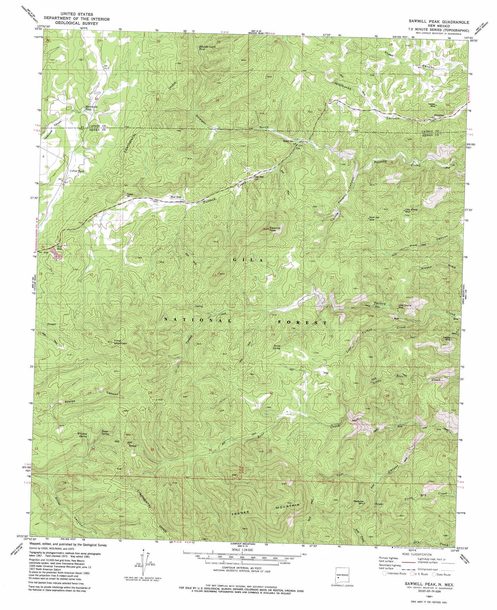
USGS Topo Quad 33107d7 - 1:24,000 scale
| Topo Map Name: | Sawmill Peak |
| USGS Topo Quad ID: | 33107d7 |
| Print Size: | ca. 21 1/4" wide x 27" high |
| Southeast Coordinates: | 33.375° N latitude / 107.75° W longitude |
| Map Center Coordinates: | 33.4375° N latitude / 107.8125° W longitude |
| U.S. State: | NM |
| Filename: | o33107d7.jpg |
| Download Map JPG Image: | Sawmill Peak topo map 1:24,000 scale |
| Map Type: | Topographic |
| Topo Series: | 7.5´ |
| Map Scale: | 1:24,000 |
| Source of Map Images: | United States Geological Survey (USGS) |
| Alternate Map Versions: |
Sawmill Peak NM 1981, updated 1981 Download PDF Buy paper map Sawmill Peak NM 1981, updated 1986 Download PDF Buy paper map Sawmill Peak NM 1999, updated 2002 Download PDF Buy paper map Sawmill Peak NM 2011 Download PDF Buy paper map Sawmill Peak NM 2013 Download PDF Buy paper map Sawmill Peak NM 2017 Download PDF Buy paper map |
| FStopo: | US Forest Service topo Sawmill Peak is available: Download FStopo PDF Download FStopo TIF |
1:24,000 Topo Quads surrounding Sawmill Peak
Pelona Mountain |
Mojonera Canyon |
Paddys Hole |
Dusty |
Welty Hill |
Indian Peaks West |
Indian Peaks East |
Wahoo Peak |
Wahoo Ranch |
Montoya Butte |
Spring Canyon |
Taylor Peak |
Sawmill Peak |
Iron Mountain |
Jaralosa Mountain |
Wall Lake |
Baily Points |
Lookout Mountain |
Winston |
Chise |
Middle Mesa |
Bonner Canyon |
Reeds Peak |
Sugarloaf Peak |
Thumb Tank Peak |
> Back to 33107a1 at 1:100,000 scale
> Back to 33106a1 at 1:250,000 scale
> Back to U.S. Topo Maps home
Sawmill Peak topo map: Gazetteer
Sawmill Peak: Mines
Ivanhoe Mine elevation 2194m 7198′Little Granite Mine elevation 2147m 7043′
Little Granite Mine elevation 2146m 7040′
Little Wonder Mine elevation 2283m 7490′
North Star Mine elevation 2309m 7575′
North Star Mine elevation 2308m 7572′
Readjustor elevation 2161m 7089′
Webber Shaft elevation 2228m 7309′
Sawmill Peak: Populated Places
Franks Place elevation 2287m 7503′Kline Place elevation 2330m 7644′
Santana Place elevation 2263m 7424′
Sawmill Peak: Reservoirs
Flat Tank elevation 2317m 7601′Hardcastle Tank elevation 2314m 7591′
Straight Gulch Tank elevation 2321m 7614′
Sawmill Peak: Springs
Faulkner Spring elevation 2204m 7230′Jenny Spring elevation 2349m 7706′
Stiver Spring elevation 2433m 7982′
Whiskey Spring elevation 2402m 7880′
Sawmill Peak: Streams
Little Turkey Creek elevation 2147m 7043′Sawmill Peak: Summits
Franks Mountain elevation 2672m 8766′Kline Mountain elevation 2571m 8435′
Sawmill Peak elevation 2545m 8349′
Sawmill Peak: Valleys
Cliff Canyon elevation 2095m 6873′Little Poverty Canyon elevation 2186m 7171′
Straight Gulch elevation 2206m 7237′
Sawmill Peak: Wells
Koko Well elevation 2237m 7339′Sawmill Peak digital topo map on disk
Buy this Sawmill Peak topo map showing relief, roads, GPS coordinates and other geographical features, as a high-resolution digital map file on DVD: