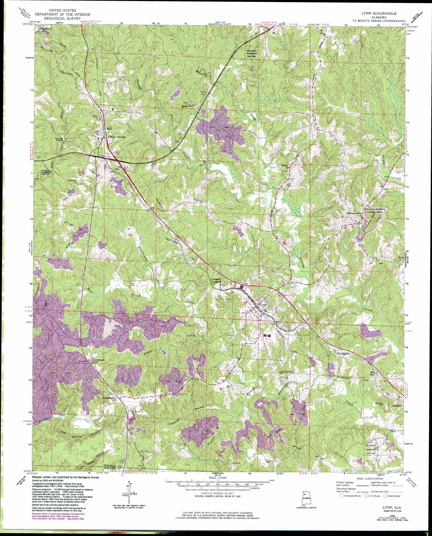
Lynn Topo Map Alabama
To zoom in, hover over the map of Lynn
USGS Topo Quad 34087a5 - 1:24,000 scale
| Topo Map Name: | Lynn |
| USGS Topo Quad ID: | 34087a5 |
| Print Size: | ca. 21 1/4" wide x 27" high |
| Southeast Coordinates: | 34° N latitude / 87.5° W longitude |
| Map Center Coordinates: | 34.0625° N latitude / 87.5625° W longitude |
| U.S. State: | AL |
| Filename: | o34087a5.jpg |
| Download Map JPG Image: | Lynn topo map 1:24,000 scale |
| Map Type: | Topographic |
| Topo Series: | 7.5´ |
| Map Scale: | 1:24,000 |
| Source of Map Images: | United States Geological Survey (USGS) |
| Alternate Map Versions: |
Lynn AL 1958, updated 1960 Download PDF Buy paper map Lynn AL 1958, updated 1969 Download PDF Buy paper map Lynn AL 1958, updated 1983 Download PDF Buy paper map Lynn AL 2011 Download PDF Buy paper map Lynn AL 2014 Download PDF Buy paper map |
| FStopo: | US Forest Service topo Lynn is available: Download FStopo PDF Download FStopo TIF |
1:24,000 Topo Quads surrounding Lynn
Hackleburg |
Phil Campbell |
Kinlock Spring |
Bee Branch |
Grayson |
Hamilton Ne |
Haleyville West |
Haleyville East |
Double Springs |
Houston |
Brilliant |
Gold Mine |
Lynn |
Poplar Springs |
Black Pond |
Winfield |
Glen Allen |
Carbon Hill |
Nauvoo |
Manchester |
Winfield Se |
Hubbertville |
Howard |
Townley |
Jasper |
> Back to 34087a1 at 1:100,000 scale
> Back to 34086a1 at 1:250,000 scale
> Back to U.S. Topo Maps home
Lynn topo map: Gazetteer
Lynn: Arches
Natural Bridge of Alabama elevation 198m 649′Lynn: Dams
Barton Fishing Lake Dam Two elevation 171m 561′Bartons Fishing Lake Dam elevation 164m 538′
O L and Ema Hicks Lake Dam elevation 195m 639′
Lynn: Mines
Dodd Drift Mine elevation 195m 639′Ice Berg Mine elevation 225m 738′
Natural Bridge Mine elevation 214m 702′
West Mine elevation 225m 738′
Lynn: Parks
David Posey Memorial Stadium elevation 214m 702′Lynn: Populated Places
Farriss (historical) elevation 245m 803′German Crossing elevation 228m 748′
Glen Mary elevation 220m 721′
Lynn elevation 221m 725′
Natural Bridge elevation 232m 761′
Lynn: Post Offices
Glenmary Post Office (historical) elevation 219m 718′Lynn Post Office elevation 219m 718′
Natural Bridge Post Office elevation 219m 718′
Lynn: Reservoirs
O L and Ema Hicks Lake elevation 195m 639′Verlie Barton Lake One elevation 164m 538′
Verlie Barton Lake Two elevation 171m 561′
Lynn: Streams
Lincoln Branch elevation 174m 570′Little Creek elevation 175m 574′
Meadow Creek elevation 170m 557′
Old Spring Branch elevation 160m 524′
Plunket Branch elevation 170m 557′
West Prong Blackwater Creek elevation 182m 597′
Lynn: Summits
Millstone Mountain elevation 281m 921′Lynn digital topo map on disk
Buy this Lynn topo map showing relief, roads, GPS coordinates and other geographical features, as a high-resolution digital map file on DVD: