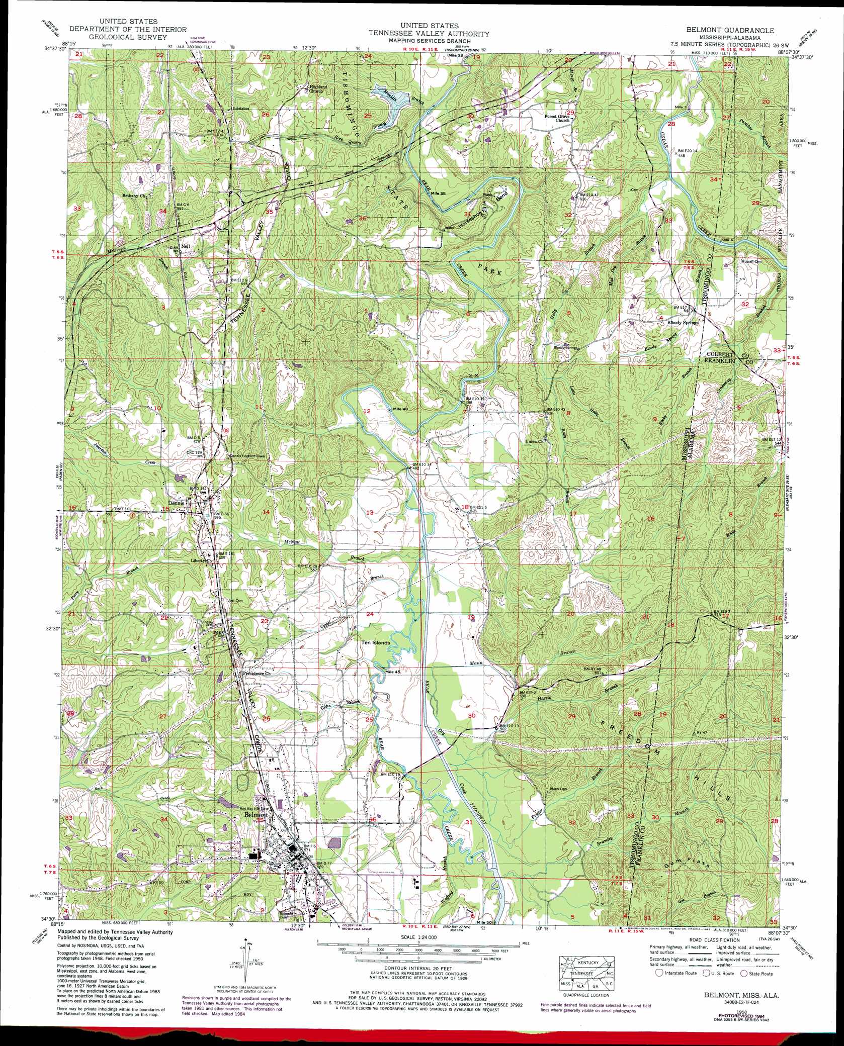
Belmont Topo Map Mississippi
To zoom in, hover over the map of Belmont
USGS Topo Quad 34088e2 - 1:24,000 scale
| Topo Map Name: | Belmont |
| USGS Topo Quad ID: | 34088e2 |
| Print Size: | ca. 21 1/4" wide x 27" high |
| Southeast Coordinates: | 34.5° N latitude / 88.125° W longitude |
| Map Center Coordinates: | 34.5625° N latitude / 88.1875° W longitude |
| U.S. States: | MS, AL |
| Filename: | o34088e2.jpg |
| Download Map JPG Image: | Belmont topo map 1:24,000 scale |
| Map Type: | Topographic |
| Topo Series: | 7.5´ |
| Map Scale: | 1:24,000 |
| Source of Map Images: | United States Geological Survey (USGS) |
| Alternate Map Versions: |
Belmont MS 1936, updated 1936 Download PDF Buy paper map Belmont MS 1950, updated 1971 Download PDF Buy paper map Belmont MS 1950, updated 1985 Download PDF Buy paper map Belmont MS 1951, updated 1951 Download PDF Buy paper map Belmont MS 2012 Download PDF Buy paper map Belmont MS 2015 Download PDF Buy paper map |
1:24,000 Topo Quads surrounding Belmont
Glens |
Burnsville |
Iuka |
Margerum |
Cherokee |
Altitude |
Paden |
Tishomingo |
Bishop |
Barton |
Marietta |
Paden Se |
Belmont |
Pleasant Site |
Pleasant Grove |
Kirkville |
Fulton Ne |
Red Bay |
Halltown |
Guinn Cross Roads |
Fulton |
Fulton Se |
Shottsville |
Vina |
Hodges |
> Back to 34088e1 at 1:100,000 scale
> Back to 34088a1 at 1:250,000 scale
> Back to U.S. Topo Maps home
Belmont topo map: Gazetteer
Belmont: Bends
Horseshoe Bend elevation 166m 544′Belmont: Bridges
Belmont Bridge elevation 149m 488′Dennis Bridge elevation 142m 465′
Southward Bridge elevation 135m 442′
Belmont: Channels
Bear Creek Floodway elevation 146m 479′Belmont: Dams
Tishomingo State Park Lake Dam elevation 152m 498′Belmont: Flats
Gum Flats elevation 196m 643′Ten Island elevation 144m 472′
Belmont: Parks
Belmont Blue Springs Park elevation 167m 547′Tishomingo State Park elevation 158m 518′
Belmont: Populated Places
Belmont elevation 177m 580′Bloody Springs elevation 164m 538′
Dennis elevation 177m 580′
Neil elevation 166m 544′
Belmont: Post Offices
Mann Post Office (historical) elevation 157m 515′Belmont: Ridges
Chinquapin Ridge elevation 208m 682′Belmont: Springs
Blue Springs elevation 169m 554′Belmont: Streams
Bill Wood Branch elevation 147m 482′Bloody Spring Branch elevation 133m 436′
Bridges Branch elevation 142m 465′
Brumley Branch elevation 147m 482′
Brumley Branch elevation 147m 482′
Camel Branch elevation 143m 469′
Carr Branch elevation 145m 475′
Crossway Branch elevation 135m 442′
Dry Creek elevation 143m 469′
Epps Branch elevation 145m 475′
Fowler Branch elevation 147m 482′
Fowler Branch elevation 146m 479′
Harris Branch elevation 146m 479′
Harris Branch elevation 146m 479′
Holly Branch elevation 134m 439′
Little Holly Branch elevation 167m 547′
Mad Dog Branch elevation 137m 449′
Mann Branch elevation 146m 479′
Mann Branch elevation 145m 475′
Mauldin Branch elevation 134m 439′
Mauldin Branch elevation 141m 462′
McNutt Branch elevation 142m 465′
McRae Branch elevation 139m 456′
McRoe Branch elevation 137m 449′
Panther Branch elevation 133m 436′
Panther Branch elevation 134m 439′
Rock Quarry Branch elevation 140m 459′
Rocky Branch elevation 147m 482′
Rocky Branch elevation 147m 482′
Wofford Branch elevation 147m 482′
Belmont: Summits
Freedom Hills elevation 196m 643′Belmont digital topo map on disk
Buy this Belmont topo map showing relief, roads, GPS coordinates and other geographical features, as a high-resolution digital map file on DVD: