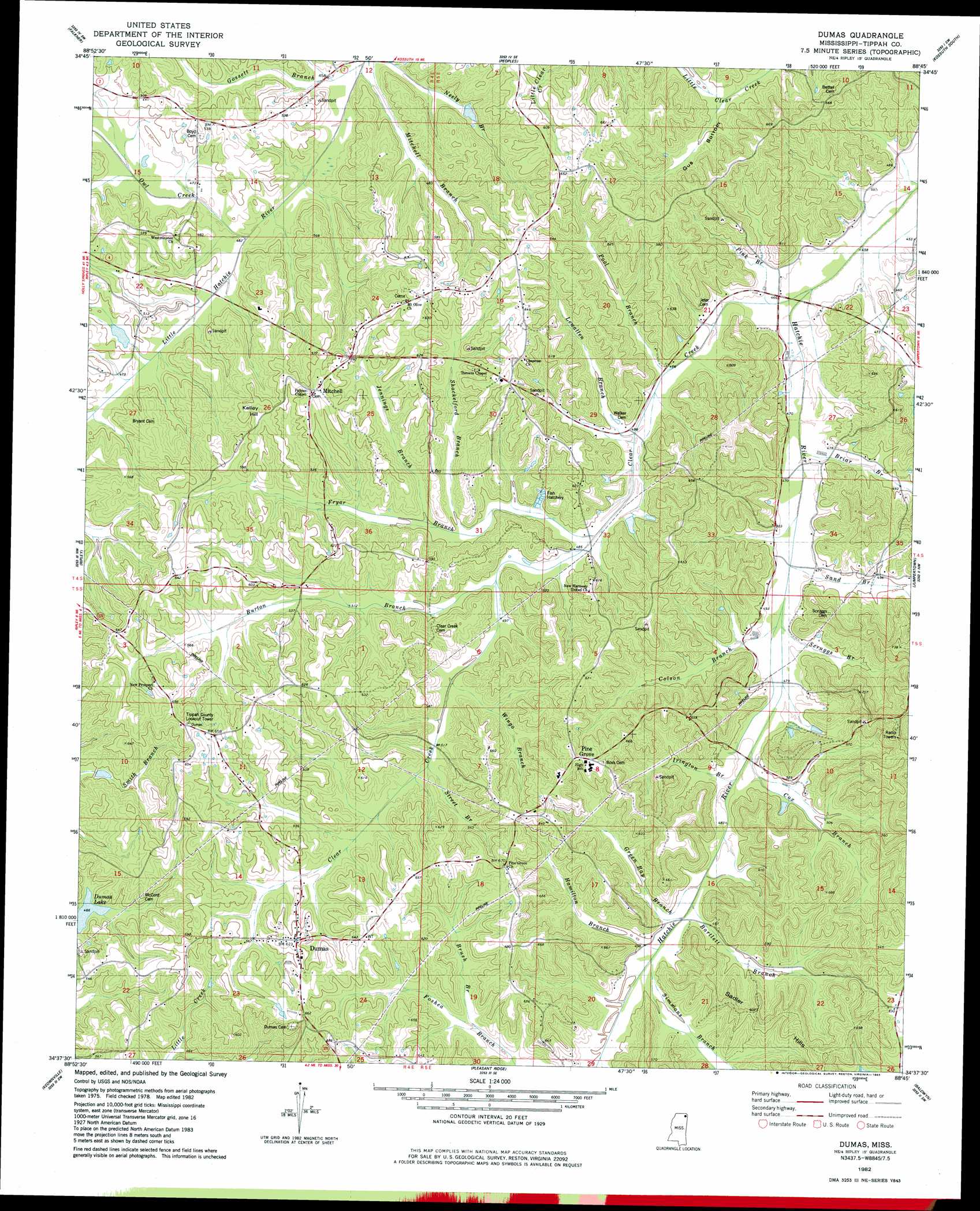
Dumas Topo Map Mississippi
To zoom in, hover over the map of Dumas
USGS Topo Quad 34088f7 - 1:24,000 scale
| Topo Map Name: | Dumas |
| USGS Topo Quad ID: | 34088f7 |
| Print Size: | ca. 21 1/4" wide x 27" high |
| Southeast Coordinates: | 34.625° N latitude / 88.75° W longitude |
| Map Center Coordinates: | 34.6875° N latitude / 88.8125° W longitude |
| U.S. State: | MS |
| Filename: | o34088f7.jpg |
| Download Map JPG Image: | Dumas topo map 1:24,000 scale |
| Map Type: | Topographic |
| Topo Series: | 7.5´ |
| Map Scale: | 1:24,000 |
| Source of Map Images: | United States Geological Survey (USGS) |
| Alternate Map Versions: |
Dumas MS 1982, updated 1983 Download PDF Buy paper map Dumas MS 2012 Download PDF Buy paper map Dumas MS 2015 Download PDF Buy paper map |
1:24,000 Topo Quads surrounding Dumas
Camp Hill |
Walnut |
Chalybeate |
Kossuth North |
Corinth |
Whitten Town |
Falkner |
Peoples |
Kossuth South |
Rienzi |
Blue Mountain |
Ripley |
Dumas |
Jumpertown |
Booneville |
Myrtle |
Keownville |
Pleasant Ridge |
Baldwyn |
Wheeler |
New Albany West |
New Albany East |
Ellistown |
Guntown |
Ratliff |
> Back to 34088e1 at 1:100,000 scale
> Back to 34088a1 at 1:250,000 scale
> Back to U.S. Topo Maps home
Dumas topo map: Gazetteer
Dumas: Dams
D Carmichael Pond Dam elevation 154m 505′West Hatchie Structure 29 Dam elevation 153m 501′
West Hatchie Watershed 25 Dam elevation 145m 475′
Dumas: Lakes
Dumas Lake elevation 144m 472′Dumas: Populated Places
Dumas elevation 190m 623′Mitchell elevation 191m 626′
Pine Grove elevation 199m 652′
Dumas: Streams
Bartlett Branch elevation 147m 482′Briar Branch elevation 139m 456′
Brush Branch elevation 159m 521′
Burton Branch elevation 168m 551′
Clear Creek elevation 137m 449′
Colson Branch elevation 141m 462′
Cox Branch elevation 147m 482′
Fryar Branch elevation 149m 488′
Gossett Branch elevation 147m 482′
Green Bay Branch elevation 147m 482′
Hamilton Branch elevation 147m 482′
Irington Branch elevation 145m 475′
Jennings Branch elevation 154m 505′
Lewallen Branch elevation 146m 479′
Mitchell Branch elevation 141m 462′
Owl Creek elevation 139m 456′
Pink Branch elevation 140m 459′
Pool Branch elevation 141m 462′
Sand Branch elevation 141m 462′
Scruggs Branch elevation 141m 462′
Shackelford Branch elevation 150m 492′
Simmons Branch elevation 148m 485′
Street Branch elevation 167m 547′
Wingo Branch elevation 153m 501′
Dumas: Summits
Kelley Hill elevation 177m 580′Sadler Hills elevation 195m 639′
Dumas: Valleys
Gus Bottom elevation 154m 505′Dumas digital topo map on disk
Buy this Dumas topo map showing relief, roads, GPS coordinates and other geographical features, as a high-resolution digital map file on DVD: