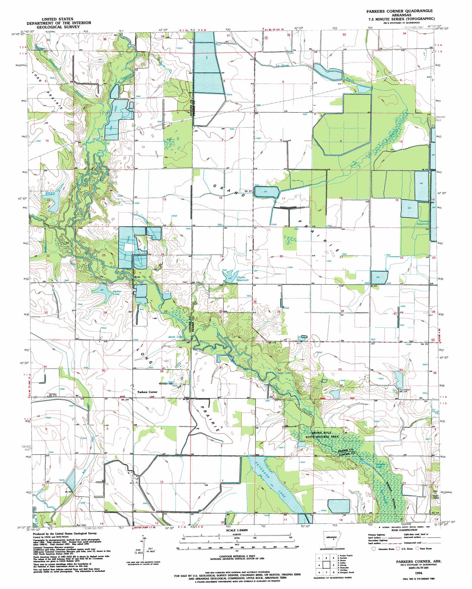
Parkers Corner Topo Map Arkansas
To zoom in, hover over the map of Parkers Corner
USGS Topo Quad 34091f6 - 1:24,000 scale
| Topo Map Name: | Parkers Corner |
| USGS Topo Quad ID: | 34091f6 |
| Print Size: | ca. 21 1/4" wide x 27" high |
| Southeast Coordinates: | 34.625° N latitude / 91.625° W longitude |
| Map Center Coordinates: | 34.6875° N latitude / 91.6875° W longitude |
| U.S. State: | AR |
| Filename: | o34091f6.jpg |
| Download Map JPG Image: | Parkers Corner topo map 1:24,000 scale |
| Map Type: | Topographic |
| Topo Series: | 7.5´ |
| Map Scale: | 1:24,000 |
| Source of Map Images: | United States Geological Survey (USGS) |
| Alternate Map Versions: |
Parkers Corner AR 1969, updated 1971 Download PDF Buy paper map Parkers Corner AR 1969, updated 1988 Download PDF Buy paper map Parkers Corner AR 1994, updated 1994 Download PDF Buy paper map Parkers Corner AR 2011 Download PDF Buy paper map Parkers Corner AR 2014 Download PDF Buy paper map |
1:24,000 Topo Quads surrounding Parkers Corner
Oak Grove |
Wattensaw |
Hickory Plains |
Des Arc West |
Des Arc East |
Lonoke |
Pocket Prarie |
Carlisle |
Hazen |
De Valls Bluff |
Pettus |
Culler |
Parkers Corner |
Slovak |
Roe |
England |
Humnoke |
Geridge |
Stuttgart North |
Ulm |
Sherrill |
Gethsemane |
Humphrey |
Stuttgart South |
Almyra |
> Back to 34091e1 at 1:100,000 scale
> Back to 34090a1 at 1:250,000 scale
> Back to U.S. Topo Maps home
Parkers Corner topo map: Gazetteer
Parkers Corner: Bridges
Gately Bridge (historical) elevation 61m 200′Parkers Corner: Canals
Blue Point Ditch elevation 61m 200′Parkers Corner: Dams
Joe Uhiren Reservoir Dam elevation 67m 219′Parker Lake Dam elevation 61m 200′
Peterson Lake Dam elevation 62m 203′
Parkers Corner: Flats
Grand Prairie elevation 67m 219′Parkers Corner: Lakes
Cooper Lake elevation 60m 196′Jarvis Lake elevation 60m 196′
Tyler Lake elevation 59m 193′
Parkers Corner: Populated Places
Parkers Corner elevation 64m 209′Parkers Corner: Reservoirs
Joe Uhiren Reservoir elevation 67m 219′Parker Lake elevation 61m 200′
Peterson Lake elevation 62m 203′
Parkers Corner: Streams
Shumaker Branch elevation 63m 206′Skinners Branch elevation 63m 206′
South Branch LaGrue Bayou elevation 65m 213′
Parkers Corner: Swamps
Gum Swamp elevation 60m 196′Parkers Corner digital topo map on disk
Buy this Parkers Corner topo map showing relief, roads, GPS coordinates and other geographical features, as a high-resolution digital map file on DVD: