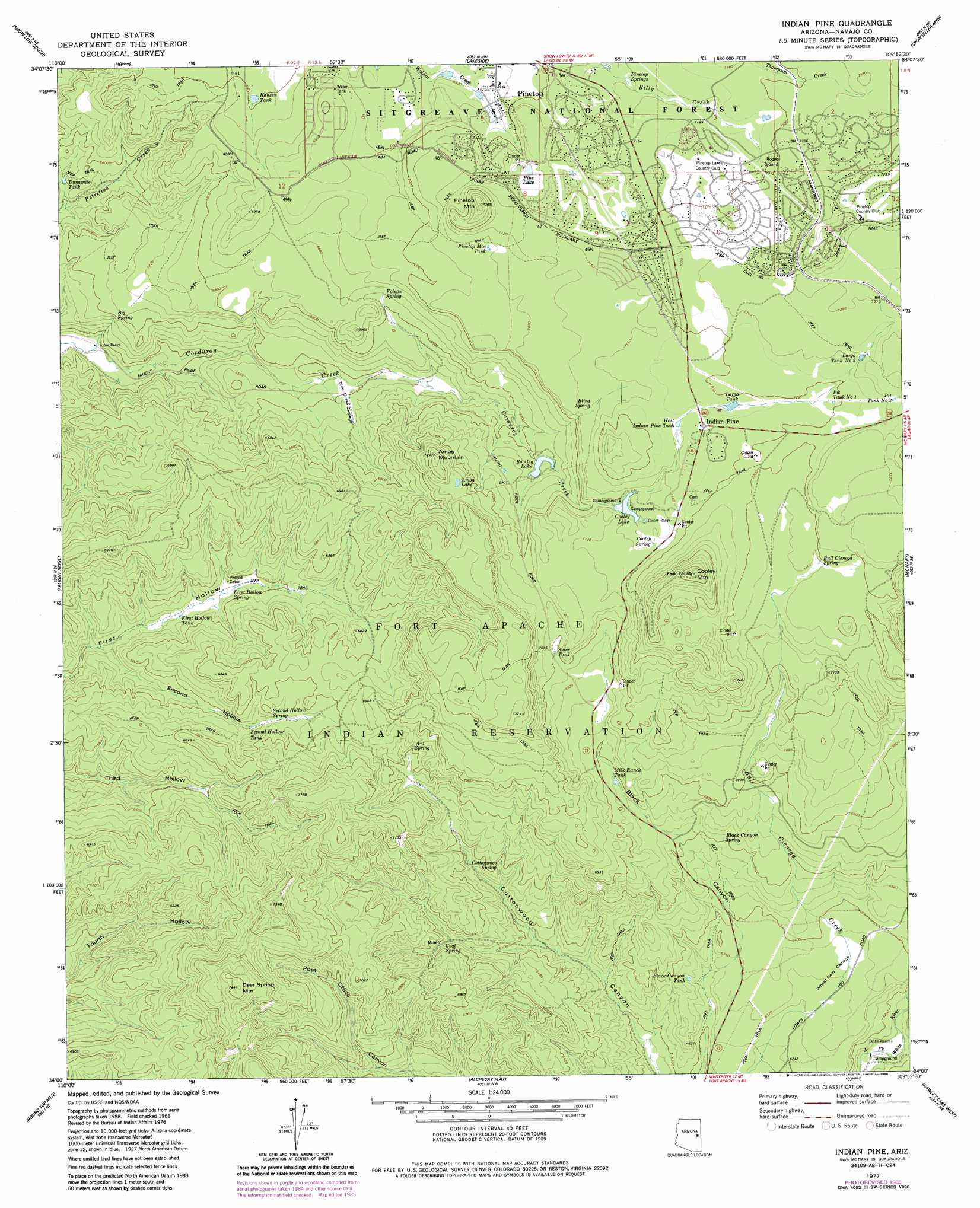
Indian Pine Topo Map Arizona
To zoom in, hover over the map of Indian Pine
USGS Topo Quad 34109a8 - 1:24,000 scale
| Topo Map Name: | Indian Pine |
| USGS Topo Quad ID: | 34109a8 |
| Print Size: | ca. 21 1/4" wide x 27" high |
| Southeast Coordinates: | 34° N latitude / 109.875° W longitude |
| Map Center Coordinates: | 34.0625° N latitude / 109.9375° W longitude |
| U.S. State: | AZ |
| Filename: | o34109a8.jpg |
| Download Map JPG Image: | Indian Pine topo map 1:24,000 scale |
| Map Type: | Topographic |
| Topo Series: | 7.5´ |
| Map Scale: | 1:24,000 |
| Source of Map Images: | United States Geological Survey (USGS) |
| Alternate Map Versions: |
Indian Pine AZ 1976, updated 1977 Download PDF Buy paper map Indian Pine AZ 1977, updated 1978 Download PDF Buy paper map Indian Pine AZ 1977, updated 1986 Download PDF Buy paper map Indian Pine AZ 1977, updated 1988 Download PDF Buy paper map Indian Pine AZ 1998, updated 2000 Download PDF Buy paper map Indian Pine AZ 2011 Download PDF Buy paper map Indian Pine AZ 2014 Download PDF Buy paper map |
| FStopo: | US Forest Service topo Indian Pine is available: Download FStopo PDF Download FStopo TIF |
1:24,000 Topo Quads surrounding Indian Pine
Pinedale |
Show Low North |
Silver Springs |
Ortega Mountain |
Vernon |
Red Top Mountain |
Show Low South |
Lakeside |
Sponseller Mountain |
Boundary Butte |
Long Tom Canyon |
Faught Ridge |
Indian Pine |
Mcnary |
Horseshoe Cienega |
Cedar Creek |
Round Top Mountain |
Alchesay Flat |
Hawley Lake West |
Hawley Lake East |
Cone Butte |
Canyon Day |
Whiteriver |
Corn Creek Plateau |
Marshall Butte |
> Back to 34109a1 at 1:100,000 scale
> Back to 34108a1 at 1:250,000 scale
> Back to U.S. Topo Maps home
Indian Pine topo map: Gazetteer
Indian Pine: Dams
Bootleg Dam elevation 2089m 6853′Cooley Dam elevation 2166m 7106′
Indian Pine: Flats
Blue Grass Cienega elevation 2010m 6594′Wheat Field Cienega elevation 1936m 6351′
Indian Pine: Lakes
Amos Lake elevation 2166m 7106′Indian Pine: Populated Places
Indian Pine elevation 2187m 7175′Indian Pine: Post Offices
Pinetop Post Office elevation 2119m 6952′Indian Pine: Reservoirs
Black Canyon Tank elevation 1926m 6318′Bootleg Lake elevation 2082m 6830′
Cooley Lake elevation 2159m 7083′
Creek Tank elevation 2202m 7224′
Dynamite Tank elevation 1987m 6519′
First Hollow Tank elevation 1983m 6505′
Fletcher Tank elevation 2183m 7162′
Hansen Tank elevation 2073m 6801′
Largo Tank elevation 2189m 7181′
Largo Tank Number Two elevation 2207m 7240′
Milk Ranch Tank elevation 2058m 6751′
Pine Lake elevation 2158m 7080′
Pinetop Mountain Tank elevation 2157m 7076′
Pit Tank Number One elevation 2195m 7201′
Pit Tank Number Two elevation 2211m 7253′
Second Hollow Tank elevation 2028m 6653′
Snow Tank elevation 2135m 7004′
Thompson Tank elevation 2228m 7309′
West Indian Pine Tank elevation 2185m 7168′
Indian Pine: Springs
A- One Spring elevation 2104m 6902′Big Spring elevation 2000m 6561′
Black Canyon Spring elevation 2021m 6630′
Blind Spring elevation 2170m 7119′
Bull Cienega Spring elevation 2187m 7175′
Coal Spring elevation 1996m 6548′
Cooley Spring elevation 2170m 7119′
Cottonwood Spring elevation 1987m 6519′
First Hollow Spring elevation 1995m 6545′
Folette Spring elevation 2085m 6840′
Pinetop Springs elevation 2170m 7119′
Second Hollow Spring elevation 2043m 6702′
Indian Pine: Streams
Bull Cienega Creek elevation 1964m 6443′Indian Pine: Summits
Amos Mountain elevation 2218m 7276′Cooley Mountain elevation 2346m 7696′
Deer Spring Mountain elevation 2259m 7411′
Pinetop Mountain elevation 2243m 7358′
Indian Pine: Valleys
Second Hollow elevation 1962m 6437′Indian Pine digital topo map on disk
Buy this Indian Pine topo map showing relief, roads, GPS coordinates and other geographical features, as a high-resolution digital map file on DVD: