Cornville Topo Map Arizona
To zoom in, hover over the map of Cornville
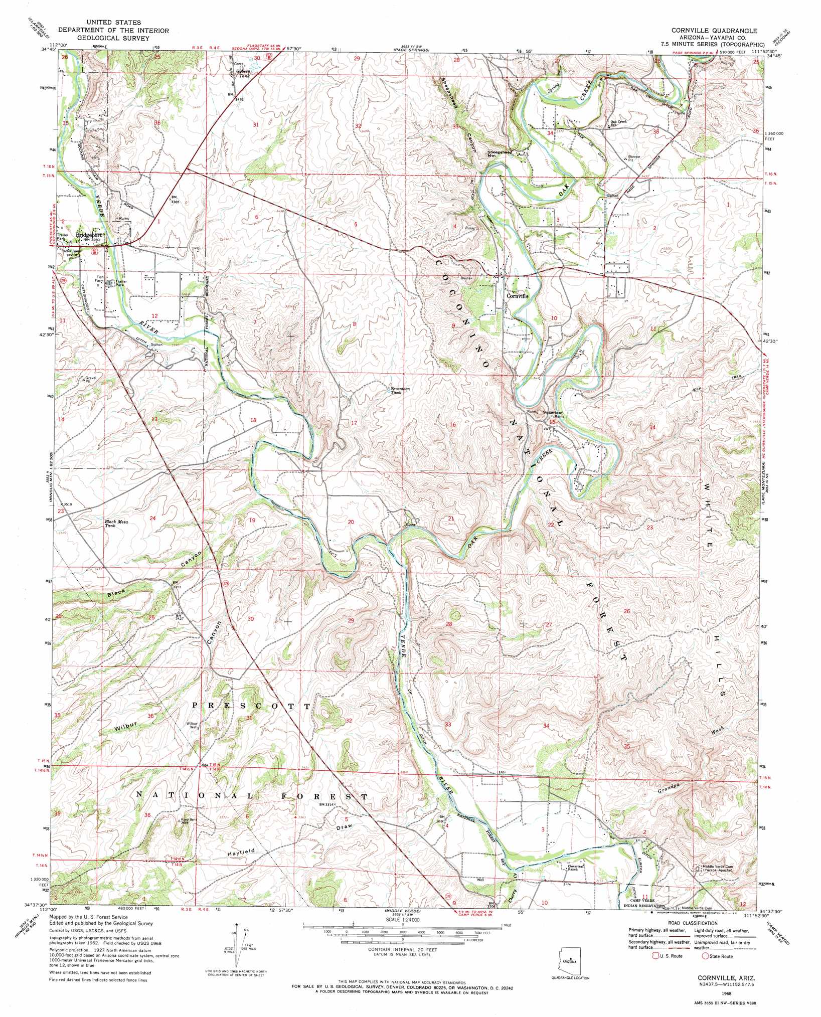
USGS Topo Quad 34111f8 - 1:24,000 scale
| Topo Map Name: | Cornville |
| USGS Topo Quad ID: | 34111f8 |
| Print Size: | ca. 21 1/4" wide x 27" high |
| Southeast Coordinates: | 34.625° N latitude / 111.875° W longitude |
| Map Center Coordinates: | 34.6875° N latitude / 111.9375° W longitude |
| U.S. State: | AZ |
| Filename: | o34111f8.jpg |
| Download Map JPG Image: | Cornville topo map 1:24,000 scale |
| Map Type: | Topographic |
| Topo Series: | 7.5´ |
| Map Scale: | 1:24,000 |
| Source of Map Images: | United States Geological Survey (USGS) |
| Alternate Map Versions: |
Cornville AZ 1968, updated 1971 Download PDF Buy paper map Cornville AZ 1968, updated 1971 Download PDF Buy paper map Cornville AZ 2012 Download PDF Buy paper map Cornville AZ 2014 Download PDF Buy paper map |
| FStopo: | US Forest Service topo Cornville is available: Download FStopo PDF Download FStopo TIF |
1:24,000 Topo Quads surrounding Cornville
Perkinsville |
Sycamore Basin |
Loy Butte |
Wilson Mountain |
Munds Park |
Munds Draw |
Clarkdale |
Page Springs |
Sedona |
Munds Mountain |
Hickey Mountain |
Cottonwood |
Cornville |
Lake Montezuma |
Casner Butte |
Humboldt |
Cherry |
Middle Verde |
Camp Verde |
Walker Mountain |
Mayer |
Estler Peak |
Arnold Mesa |
Horner Mountain |
Hackberry Mountain |
> Back to 34111e1 at 1:100,000 scale
> Back to 34110a1 at 1:250,000 scale
> Back to U.S. Topo Maps home
Cornville topo map: Gazetteer
Cornville: Airports
Solair Estates Airport elevation 1054m 3458′Cornville: Canals
Cornville Ditch elevation 1011m 3316′Oak Creek Ditch elevation 1038m 3405′
Ok Ditch elevation 967m 3172′
Cornville: Crossings
Sheeps Crossing elevation 969m 3179′Cornville: Dams
Tat Momolikot Dam elevation 964m 3162′Cornville: Populated Places
Bignotti elevation 983m 3225′Bridgeport elevation 1000m 3280′
Cornville elevation 1010m 3313′
Jordan elevation 994m 3261′
Smelter City elevation 1002m 3287′
Verde elevation 1000m 3280′
Cornville: Post Offices
Cornville Post Office elevation 1012m 3320′Cornville: Reservoirs
Black Mesa Tank elevation 1055m 3461′Gyberg Tank elevation 1068m 3503′
Seventeen Tank elevation 1036m 3398′
Trick Tank elevation 1061m 3480′
Cornville: Streams
Cherry Creek elevation 964m 3162′Oak Creek elevation 970m 3182′
Spring Creek elevation 1025m 3362′
Cornville: Summits
Sheepshead Mountain elevation 1058m 3471′Sugarloaf elevation 1073m 3520′
Cornville: Valleys
Black Canyon elevation 976m 3202′Grandpa Wash elevation 969m 3179′
Hayfield Draw elevation 969m 3179′
Sheepshead Canyon elevation 1005m 3297′
Wilbur Canyon elevation 977m 3205′
Cornville: Wells
Wilbur Well elevation 1055m 3461′Cornville digital topo map on disk
Buy this Cornville topo map showing relief, roads, GPS coordinates and other geographical features, as a high-resolution digital map file on DVD: