Humboldt Topo Map Arizona
To zoom in, hover over the map of Humboldt
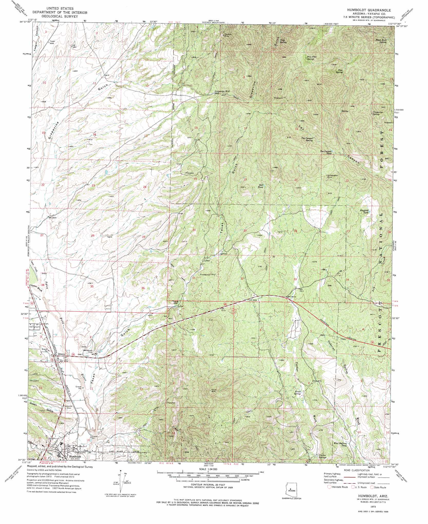
USGS Topo Quad 34112e2 - 1:24,000 scale
| Topo Map Name: | Humboldt |
| USGS Topo Quad ID: | 34112e2 |
| Print Size: | ca. 21 1/4" wide x 27" high |
| Southeast Coordinates: | 34.5° N latitude / 112.125° W longitude |
| Map Center Coordinates: | 34.5625° N latitude / 112.1875° W longitude |
| U.S. State: | AZ |
| Filename: | o34112e2.jpg |
| Download Map JPG Image: | Humboldt topo map 1:24,000 scale |
| Map Type: | Topographic |
| Topo Series: | 7.5´ |
| Map Scale: | 1:24,000 |
| Source of Map Images: | United States Geological Survey (USGS) |
| Alternate Map Versions: |
Humboldt AZ 1973, updated 1977 Download PDF Buy paper map Humboldt AZ 2012 Download PDF Buy paper map Humboldt AZ 2014 Download PDF Buy paper map |
| FStopo: | US Forest Service topo Humboldt is available: Download FStopo PDF Download FStopo TIF |
1:24,000 Topo Quads surrounding Humboldt
Chino Valley North |
King Canyon |
Munds Draw |
Clarkdale |
Page Springs |
Chino Valley South |
Prescott Valley North |
Hickey Mountain |
Cottonwood |
Cornville |
Prescott |
Prescott Valley South |
Humboldt |
Cherry |
Middle Verde |
Groom Creek |
Poland Junction |
Mayer |
Estler Peak |
Arnold Mesa |
Battleship Butte |
Battle Flat |
Cleator |
Cordes Junction |
Dugas |
> Back to 34112e1 at 1:100,000 scale
> Back to 34112a1 at 1:250,000 scale
> Back to U.S. Topo Maps home
Humboldt topo map: Gazetteer
Humboldt: Mines
Ambassador Mine elevation 1657m 5436′Shylock Mine elevation 1790m 5872′
Humboldt: Populated Places
Dewey elevation 1395m 4576′Dewey-Humboldt elevation 1397m 4583′
Humboldt elevation 1391m 4563′
Humboldt: Post Offices
Dewey Post Office elevation 1397m 4583′Humboldt Post Office elevation 1397m 4583′
Humboldt: Reservoirs
Hayfield Tank elevation 1559m 5114′Hell Tank elevation 1630m 5347′
Tex Canyon Tank elevation 1659m 5442′
Trick Tank elevation 1689m 5541′
West Pasture Tank elevation 1365m 4478′
Humboldt: Springs
Black Rock Spring elevation 1817m 5961′Bruce Spring elevation 1425m 4675′
Cement Spring elevation 1712m 5616′
Grapevine Spring elevation 1699m 5574′
Lower Grapevine Spring elevation 1610m 5282′
Pine Flat Spring elevation 1951m 6400′
Pine Spring elevation 1840m 6036′
Tex Canyon Spring elevation 1708m 5603′
Trap Spring elevation 1817m 5961′
Yarber Springs elevation 1384m 4540′
Humboldt: Streams
Clipper Wash elevation 1408m 4619′Lynx Creek elevation 1407m 4616′
Humboldt: Valleys
Green Gulch elevation 1368m 4488′Texas Gulch elevation 1372m 4501′
Humboldt: Wells
Grapevine Well elevation 1629m 5344′Yarber Well elevation 1391m 4563′
Humboldt digital topo map on disk
Buy this Humboldt topo map showing relief, roads, GPS coordinates and other geographical features, as a high-resolution digital map file on DVD: